FAA INFORMATION EFFECTIVE 09 JULY 2026
Location
| FAA Identifier: | SGT |
| Lat/Long: | 34-35-58.1227N 091-34-30.0010W
34-35.968712N 091-34.500017W
34.5994785,-91.5750003
(estimated) |
| Elevation: | 224.4 ft. / 68.4 m (surveyed) |
| Variation: | 02E (2000) |
| From city: | 7 miles N of STUTTGART, AR |
| Time zone: | UTC -5 (UTC -6 during Standard Time) |
| Zip code: | 72160 |
Airport Operations
| Airport use: | Open to the public |
| Activation date: | 10/1943 |
| Control tower: | no |
| ARTCC: | MEMPHIS CENTER |
| FSS: | JONESBORO FLIGHT SERVICE STATION |
| NOTAMs facility: | SGT (NOTAM-D service available) |
| Attendance: | NOV-JAN 0800-2000, FEB-OCT MON-FRI 0800-1600 |
| Wind indicator: | yes |
| Segmented circle: | yes |
| Lights: | ACTVT MALSF RWY 36; REIL RWY 18 & 27; PAPI RWY 09 & 27; MIRL RWYS 09/27 & 18/36 - CTAF. |
| Beacon: | white-green (lighted land airport)
Operates sunset to sunrise. |
Airport Communications
| CTAF/UNICOM: | 122.8 |
| WX AWOS-3PT: | 119.025 (870-673-1884) |
| LITTLE ROCK APPROACH: | 135.4 |
| LITTLE ROCK DEPARTURE: | 135.4 |
| CLEARANCE DELIVERY: | 123.7 |
| WX AWOS-2 at 4M3 (14 nm NW): | 119.275 (870-639-4710) |
Nearby radio navigation aids
| VOR radial/distance | | VOR name | | Freq | | Var |
|---|
| PBFr035/27.4 | | PINE BLUFF VOR/DME | | 116.00 | | 04E |
| LITr114/31.1 | | LITTLE ROCK VORTAC | | 115.10 | | 00W |
Airport Services
| Fuel available: | 100LL JET-A
100LL:100LL AVBL 24 HRS SELF-SERVE WITH CREDIT CARD. FOR FUEL NGTS CALL 870-672-2005. |
| Parking: | tiedowns |
| Airframe service: | NONE |
| Powerplant service: | NONE |
| Bulk oxygen: | NONE |
Runway Information
Runway 18/36
| Dimensions: | 6015 x 100 ft. / 1833 x 30 m |
| Surface: | asphalt/grooved, in good condition |
| Weight bearing capacity: | | Single wheel: | 75.0 | | Double wheel: | 150.0 | | Double tandem: | 200.0 | | Dual double tandem: | 300.0 |
|
| Runway edge lights: | medium intensity |
| RUNWAY 18 | | RUNWAY 36 |
| Latitude: | 34-36.250840N | | 34-35.259745N |
| Longitude: | 091-34.708683W | | 091-34.747477W |
| Elevation: | 220.1 ft. | | 222.8 ft. |
| Traffic pattern: | left | | left |
| Runway heading: | 180 magnetic, 182 true | | 000 magnetic, 002 true |
| Markings: | precision, in good condition | | precision, in good condition |
| Approach lights: | | | MALSF: 1,400 foot medium intensity approach lighting system with sequenced flashers |
| Runway end identifier lights: | yes | | no |
| Touchdown point: | yes, no lights | | yes, no lights |
| Instrument approach: | | | ILS/DME |
Runway 9/27
| Dimensions: | 5002 x 150 ft. / 1525 x 46 m |
| Surface: | concrete, in good condition |
| Weight bearing capacity: | | Single wheel: | 25.0 | | Double wheel: | 65.0 | | Double tandem: | 120.0 |
|
| Runway edge lights: | medium intensity |
| Runway edge markings: | RWY NR FADED. |
| RUNWAY 9 | | RUNWAY 27 |
| Latitude: | 34-36.239130N | | 34-36.212077N |
| Longitude: | 091-34.724117W | | 091-33.727422W |
| Elevation: | 219.6 ft. | | 218.6 ft. |
| Traffic pattern: | left | | left |
| Runway heading: | 090 magnetic, 092 true | | 270 magnetic, 272 true |
| Markings: | basic, in fair condition | | basic, in fair condition |
| Visual slope indicator: | 2-light PAPI on left (3.00 degrees glide path) | | 2-light PAPI on left (3.00 degrees glide path) |
| Runway end identifier lights: | no | | yes |
| Touchdown point: | yes, no lights | | yes, no lights |
Airport Ownership and Management from official FAA records
| Ownership: | Publicly-owned |
| Owner: | CITY OF STUTTGART
304 S. MAPLE
STUTTGART, AR 72160
Phone 870-673-3535 |
| Manager: | ANTHONY TIBBETT
2000 AIRPORT RD TERMINAL BLD
STUTTGART, AR 72160
Phone 870-673-2960
AIRPORTMANAGER@STUTTGARTAR.COM |
Additional Remarks
| - | MIGRATORY BIRDS ON & INVOF ARPT NOV-FEB. |
| - | NMRS AGRICULTURAL ACFT OPNS FM FEB-SEP 500 FT AGL AND BLW. |
| - | FOR CD WHEN UNA VIA FREQ CTC LITTLE ROCK APCH 501-379-2908 OR LITTLE ROCK ATCT 501-379-2911 |
| - | FOR SVC AFT HRS CALL 870-672-2005. |
Instrument Procedures
NOTE: All procedures below are presented as PDF files. If you need a reader for these files, you should download the free Adobe Reader.NOT FOR NAVIGATION. Please procure official charts for flight.
FAA instrument procedures published for use from 09 July 2026 at 0901Z to 06 August 2026 at 0900Z.
IAPs - Instrument Approach Procedures |
|---|
| ILS OR LOC RWY 36 | |
download (246KB) |
| RNAV (GPS) RWY 09 | |
download (204KB) |
| RNAV (GPS) RWY 18 | |
download (252KB) |
| RNAV (GPS) RWY 27 | |
download (215KB) |
| RNAV (GPS) RWY 36 | |
download (231KB) |
| NOTE: Special Alternate Minimums apply | |
download (73KB) |
| NOTE: Special Take-Off Minimums/Departure Procedures apply | |
download (248KB) |
Other nearby airports with instrument procedures:
M73 - Almyra Municipal Airport (12 nm SE)
4M3 - Carlisle Municipal Airport (14 nm NW)
5M1 - Dewitt Municipal Airport/Whitcomb Field (24 nm SE)
M36 - Frank Federer Memorial Airport (26 nm NE)
KPBF - Pinebluff Regional Airport/Grider Field (31 nm SW)
|
|

Road maps at:
MapQuest
Bing
Google
| Aerial photo |
|---|
WARNING: Photo may not be current or correct
 Photo courtesy of the Arkansas Department of Aeronautics
Taken in the Spring of 2007
Photo courtesy of the Arkansas Department of Aeronautics
Taken in the Spring of 2007
Do you have a better or more recent aerial photo of Stuttgart Municipal Airport / Carl Humphrey Field that you would like to share? If so, please send us your photo.
|
| Sectional chart |
|---|
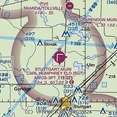
|
| Airport distance calculator |
|---|
|
|
| Sunrise and sunset |
|---|
|
Times for 24-Jul-2026
| | Local
(UTC-5) | | Zulu
(UTC) |
|---|
| Morning civil twilight | | 05:43 | | 10:43 |
| Sunrise | | 06:12 | | 11:12 |
| Sunset | | 20:14 | | 01:14 |
| Evening civil twilight | | 20:42 | | 01:42 |
|
| Current date and time |
|---|
| Zulu (UTC) | 24-Jul-2026 16:40:50 |
|---|
| Local (UTC-5) | 24-Jul-2026 11:40:50 |
|---|
|
| METAR |
|---|
| KSGT | 241620Z AUTO 01004KT 10SM OVC013 25/23 A3012 RMK AO2 $
|
|
| TAF |
|---|
KPBF
31nm SW | 241120Z 2412/2512 08005KT P6SM SCT015 OVC030 FM241500 21004KT P6SM OVC050 FM250000 15005KT P6SM OVC150 FM250600 VRB03KT P6SM OVC100
|
KLIT
33nm W | 241120Z 2412/2512 10007KT P6SM OVC025 FM241500 19005KT P6SM OVC050 FM250000 15005KT P6SM OVC100 FM250600 VRB03KT P6SM OVC100
|
KLRF
34nm NW | 241600Z 2416/2521 08008KT 9999 BKN009 OVC030 QNH3012INS BECMG 2419/2420 16007KT 9999 NSW FEW020 SCT035 QNH3003INS BECMG 2501/2502 17009KT 8000 -SHRA BKN070 QNH3000INS TEMPO 2506/2512 6000 -TSRA BKN080CB BECMG 2513/2514 24008KT 9999 NSW BKN080 OVC100 QNH3002INS TX32/2420Z TN26/2506Z
|
|
| NOTAMs |
|---|
NOTAMs are issued by the DoD/FAA and will open in a separate window not controlled by AirNav.
|
|

