FAA INFORMATION EFFECTIVE 16 APRIL 2026
Location
| FAA Identifier: | 4M3 |
| Lat/Long: | 34-48-29.6000N 091-42-43.6000W
34-48.493333N 091-42.726667W
34.8082222,-91.7121111
(estimated) |
| Elevation: | 240.8 ft. / 73.4 m (surveyed) |
| Variation: | 03E (1985) |
| From city: | 2 miles NE of CARLISLE, AR |
| Time zone: | UTC -5 (UTC -6 during Standard Time) |
| Zip code: | 72024 |
Airport Operations
| Airport use: | Open to the public |
| Activation date: | 04/1944 |
| Control tower: | no |
| ARTCC: | MEMPHIS CENTER |
| FSS: | JONESBORO FLIGHT SERVICE STATION |
| NOTAMs facility: | JBR (NOTAM-D service available) |
| Attendance: | UNATNDD |
| Wind indicator: | lighted |
| Segmented circle: | no |
| Lights: | ACTVT PAPI RWYS 09/27 & 18/36; MIRL RWY 09/27 & RWY 18/36 - CTAF. |
| Beacon: | white-green (lighted land airport)
Operates sunset to sunrise. |
Airport Communications
| CTAF/UNICOM: | 122.8 |
| WX AWOS-2: | 119.275 (870-639-4710) |
| LITTLE ROCK APPROACH: | 135.4 |
| LITTLE ROCK DEPARTURE: | 135.4 |
| CLEARANCE DELIVERY: | 135.4 |
| WX AWOS-3PT at SGT (14 nm SE): | 119.025 (870-673-1884) |
Nearby radio navigation aids
| VOR radial/distance | | VOR name | | Freq | | Var |
|---|
| LITr090/21.7 | | LITTLE ROCK VORTAC | | 115.10 | | 00W |
| PBFr013/35.3 | | PINE BLUFF VOR/DME | | 116.00 | | 04E |
Airport Services
| Fuel available: | 100LL
100LL:SELF SERVE FUEL AVBL 24 HRS WITH CREDIT CARD. |
| Parking: | tiedowns |
| Airframe service: | MAJOR |
| Powerplant service: | MAJOR |
| Bottled oxygen: | NONE |
| Bulk oxygen: | NONE |
Runway Information
Runway 9/27
| Dimensions: | 4501 x 75 ft. / 1372 x 23 m |
| Surface: | asphalt, in fair condition |
| Weight bearing capacity: | |
| Runway edge lights: | medium intensity |
| RUNWAY 9 | | RUNWAY 27 |
| Latitude: | 34-48.362955N | | 34-48.348703N |
| Longitude: | 091-43.350037W | | 091-42.450658W |
| Elevation: | 238.7 ft. | | 240.5 ft. |
| Traffic pattern: | left | | left |
| Runway heading: | 088 magnetic, 091 true | | 268 magnetic, 271 true |
| Markings: | nonprecision, in fair condition | | nonprecision, in fair condition |
| Visual slope indicator: | 2-light PAPI on left (3.00 degrees glide path) | | 2-light PAPI on left (3.00 degrees glide path) |
| Touchdown point: | yes, no lights | | yes, no lights |
| Obstructions: | none | | 3 ft. berm, 440 ft. from runway |
Runway 18/36
| Dimensions: | 4494 x 75 ft. / 1370 x 23 m |
| Surface: | asphalt, in good condition |
| Weight bearing capacity: | |
| Runway edge lights: | medium intensity |
| Runway edge markings: | RWY 18 MARKINGS FADED. |
| RUNWAY 18 | | RUNWAY 36 |
| Latitude: | 34-49.001485N | | 34-48.260788N |
| Longitude: | 091-42.545913W | | 091-42.562678W |
| Elevation: | 237.5 ft. | | 239.9 ft. |
| Traffic pattern: | left | | left |
| Runway heading: | 178 magnetic, 181 true | | 358 magnetic, 001 true |
| Markings: | nonprecision, in poor condition | | nonprecision, in fair condition |
| Visual slope indicator: | 2-light PAPI on left (3.25 degrees glide path) | | 2-light PAPI on left (3.25 degrees glide path) |
| Touchdown point: | yes, no lights | | yes, no lights |
| Obstructions: | none | | 10 ft. brush, 450 ft. from runway, 25:1 slope to clear |
Airport Ownership and Management from official FAA records
| Ownership: | Publicly-owned |
| Owner: | CITY OF CARLISLE
P.O. BOX 49
CARLISLE, AR 72024
Phone 870-552-9420 |
| Manager: | LARRY PASLEY
PO BOX 49
CARLISLE, AR 72024
Phone 870-552-5225 |
Additional Remarks
| - | NMRS AGRICULTURE OPNS YEAR ROUND. |
| - | MIGRATORY BIRDS INVOF ARPT NOV TO MARCH |
| - | FOR CD WHEN UNA VIA FREQ CTC LITTLE ROCK APCH 501-379-2908 OR LITTLE ROCK ATCT 501-379-2911 |
Instrument Procedures
NOTE: All procedures below are presented as PDF files. If you need a reader for these files, you should download the free Adobe Reader.NOT FOR NAVIGATION. Please procure official charts for flight.
FAA instrument procedures published for use from 16 April 2026 at 0901Z to 14 May 2026 at 0900Z.
IAPs - Instrument Approach Procedures |
|---|
| RNAV (GPS) RWY 09 | |
download (174KB) |
| RNAV (GPS) RWY 27 | |
download (166KB) |
| NOTE: Special Alternate Minimums apply | |
download (144KB) |
| NOTE: Special Take-Off Minimums/Departure Procedures apply | |
download (131KB) |
Other nearby airports with instrument procedures:
KSGT - Stuttgart Municipal Airport / Carl Humphrey Field (14 nm SE)
KLRF - Little Rock Air Force Base (22 nm W)
KSRC - Searcy Regional Airport (24 nm N)
KLIT - Bill and Hillary Clinton National Airport/Adams Field (26 nm W)
M73 - Almyra Municipal Airport (27 nm SE)
|
|

Road maps at:
MapQuest
Bing
Google
| Aerial photo |
|---|
WARNING: Photo may not be current or correct
 Photo courtesy of the Arkansas Department of Aeronautics
Taken in the Spring of 2007
Photo courtesy of the Arkansas Department of Aeronautics
Taken in the Spring of 2007
Do you have a better or more recent aerial photo of Carlisle Municipal Airport that you would like to share? If so, please send us your photo.
|
| Sectional chart |
|---|
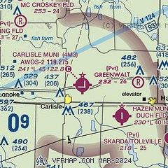
|
| Airport distance calculator |
|---|
|
|
| Sunrise and sunset |
|---|
|
Times for 28-Apr-2026
| | Local
(UTC-5) | | Zulu
(UTC) |
|---|
| Morning civil twilight | | 05:54 | | 10:54 |
| Sunrise | | 06:21 | | 11:21 |
| Sunset | | 19:48 | | 00:48 |
| Evening civil twilight | | 20:15 | | 01:15 |
|
| Current date and time |
|---|
| Zulu (UTC) | 28-Apr-2026 19:54:11 |
|---|
| Local (UTC-5) | 28-Apr-2026 14:54:11 |
|---|
|
| METAR |
|---|
KSGT
14nm SE | 281933Z AUTO 21014KT 9SM -TSRA FEW023 OVC033 25/24 A2992 RMK AO2 LTG DSNT ALQDS TSB27RAB25 P0000 $
|
KLRF
23nm W | 281939Z AUTO 16006KT 8SM -TSRA FEW015 BKN020 21/19 A2982 RMK AO2 CIG 014V020 PRESFR SLP098
|
KLIT
26nm W | 281936Z 22014G25KT 3SM -RA FEW018 BKN045 BKN070 22/19 A2983 RMK AO2 PK WND 22038/1909 RAB01 TSB06E30 PRESFR TS MOV NE P0022 T02220189 $
|
KSRC
27nm N | 281923Z AUTO 17011G18KT 4SM TSRA BR OVC007 22/21 A2987 RMK AO2 LTG DSNT ALQDS CIG 005V010 P0034 $
|
KORK
27nm W | 281935Z AUTO 19011G19KT 6SM TS BR FEW003 SCT014 SCT032 21/19 A2983 RMK AO2 LTG DSNT ALQDS
|
|
| TAF |
|---|
KLRF
23nm W | 281543Z 2815/2921 10006KT 9999 OVC012 QNH2994INS TEMPO 2815/2818 9000 -DZ OVC009 BECMG 2817/2818 15010G15KT 6000 -SHRA VCTS BKN020CB QNH2982INS TEMPO 2819/2822 19012G30KT 4800 TSRA OVC018CB BECMG 2823/2824 32010G15KT 9999 NSW SCT025 BKN040 QNH2982INS BECMG 2908/2909 35012KT 9999 BKN020 QNH2988INS BECMG 2915/2916 01010G15KT 9999 SCT080 QNH2998INS TX26/2819Z TN15/2912Z
|
KLIT
26nm W | 281720Z 2818/2918 22009KT 5SM HZ VCSH BKN019 OVC024 FM281900 20008KT 4SM -TSRA BR OVC015CB TEMPO 2819/2822 VRB15G25KT 2SM -TSRA BR OVC010CB FM282200 20007KT 2SM -RA VCTS OVC025CB FM290100 26007KT P6SM OVC010 FM291700 35008KT P6SM BKN025
|
|
| NOTAMs |
|---|
NOTAMs are issued by the DoD/FAA and will open in a separate window not controlled by AirNav.
|
|

