FAA INFORMATION EFFECTIVE 25 DECEMBER 2025
Location
| FAA Identifier: | M36 |
| Lat/Long: | 34-52-49.0000N 091-10-35.2000W
34-52.816667N 091-10.586667W
34.8802778,-91.1764444
(estimated) |
| Elevation: | 195.3 ft. / 59.5 m (surveyed) |
| Variation: | 02E (1995) |
| Time zone: | UTC -6 (UTC -5 during Daylight Saving Time) |
| Zip code: | 72021 |
Airport Operations
| Airport use: | Open to the public |
| Activation date: | 04/1941 |
| Control tower: | no |
| ARTCC: | MEMPHIS CENTER |
| FSS: | JONESBORO FLIGHT SERVICE STATION |
| NOTAMs facility: | JBR (NOTAM-D service available) |
| Attendance: | MAR-SEP MON-SAT 0800-1200, OCT-FEB MON-FRI DAYLIGHT HOURS |
| Wind indicator: | lighted |
| Segmented circle: | yes |
| Lights: | ACTVT MIRL RWY 02/20 - CTAF. |
| Beacon: | white-green (lighted land airport)
Operates sunset to sunrise. |
Airport Communications
- APCH/DEP SVC PRVDD BY MEMPHIS ARTCC ON FREQS 135.3/335.8(BRINKLEY RCAG).
Nearby radio navigation aids
| VOR radial/distance | | VOR name | | Freq | | Var |
|---|
| UJMr305/30.8 | | MARVELL VOR/DME | | 113.65 | | 01E |
Airport Services
| Fuel available: | 100LL
100LL:FUEL AVBL 24 HRS SELF SVC WITH CREDIT CARD. |
| Parking: | hangars and tiedowns |
| Airframe service: | MAJOR |
| Powerplant service: | MAJOR |
Runway Information
Runway 2/20
| Dimensions: | 4002 x 75 ft. / 1220 x 23 m |
| Surface: | asphalt, in fair condition |
| Weight bearing capacity: | |
| Runway edge lights: | medium intensity |
| RUNWAY 2 | | RUNWAY 20 |
| Latitude: | 34-52.519867N | | 34-53.113748N |
| Longitude: | 091-10.760575W | | 091-10.411818W |
| Elevation: | 195.1 ft. | | 190.6 ft. |
| Traffic pattern: | right | | left |
| Runway heading: | 024 magnetic, 026 true | | 204 magnetic, 206 true |
| Displaced threshold: | 248 ft. | | 150 ft. |
| Markings: | nonprecision, in fair condition | | nonprecision, in fair condition |
| Visual slope indicator: | 2-light PAPI on left (3.00 degrees glide path)
PAPI UNUSBL BYD 5 DEGS LEFT OF CNTRLN. | | 2-light PAPI on left (3.00 degrees glide path)
PAPI UNUSBL BYD 4 DEGS LEFT OF CNTRLN AND BYD 7 DEGS RIGHT OF CNTRLN. |
| Touchdown point: | yes, no lights | | yes, no lights |
| Obstructions: | 25 ft. pole, 525 ft. from runway, 200 ft. left of centerline, 13:1 slope to clear
ROAD & BRIDGE SIGNS AT 180 FT FM THR XNG CNTRLN. | | 50 ft. tree, 1250 ft. from runway, 130 ft. right of centerline, 21:1 slope to clear
APCH SLOPE 32:1 TO DSPLCD THR. |
Airport Ownership and Management from official FAA records
| Ownership: | Publicly-owned |
| Owner: | CITY OF BRINKLEY
233 WEST CEDAR
BRINKLEY, AR 72021
Phone 870-734-1382 |
| Manager: | KAREN GIFFORD
233 WEST CEDAR
BRINKLEY, AR 72021
Phone 870-734-6066 |
Additional Remarks
| - | WATER-TANK NW. |
| - | NMRS AGRICULTURAL ACFT OPNS FM FEB-NOV 500 FT AGL AND BLW. |
| - | FOR CD CTC MEMPHIS ARTCC AT 901-368-8453/8449. |
| - | MIGRATORY BIRDS ON & INVOF ARPT. |
| - | DEER ON & INVOF ARPT. |
Instrument Procedures
NOTE: All procedures below are presented as PDF files. If you need a reader for these files, you should download the free Adobe Reader.NOT FOR NAVIGATION. Please procure official charts for flight.
FAA instrument procedures published for use from 25 December 2025 at 0901z to 22 January 2026 at 0900z.
IAPs - Instrument Approach Procedures |
|---|
| RNAV (GPS) RWY 20 | |
download (202KB) |
| NOTE: Special Take-Off Minimums/Departure Procedures apply | |
download (410KB) |
Other nearby airports with instrument procedures:
6M7 - Marianna/Lee County Airport-Steve Edwards Field (19 nm E)
KDRP - Delta Regional Airport (22 nm NE)
M60 - Woodruff County Airport (24 nm N)
KSGT - Stuttgart Municipal Airport / Carl Humphrey Field (26 nm SW)
4M3 - Carlisle Municipal Airport (27 nm W)
|
|

Road maps at:
MapQuest
Bing
Google
| Aerial photo |
|---|
WARNING: Photo may not be current or correct
 Photo courtesy of the Arkansas Department of Aeronautics
Taken in the Spring of 2007
Photo courtesy of the Arkansas Department of Aeronautics
Taken in the Spring of 2007
Do you have a better or more recent aerial photo of Frank Federer Memorial Airport that you would like to share? If so, please send us your photo.
|
| Sectional chart |
|---|
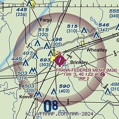
|
| Airport distance calculator |
|---|
|
|
| Sunrise and sunset |
|---|
|
Times for 20-Jan-2026
| | Local
(UTC-6) | | Zulu
(UTC) |
|---|
| Morning civil twilight | | 06:44 | | 12:44 |
| Sunrise | | 07:11 | | 13:11 |
| Sunset | | 17:20 | | 23:20 |
| Evening civil twilight | | 17:47 | | 23:47 |
|
| Current date and time |
|---|
| Zulu (UTC) | 20-Jan-2026 13:59:51 |
|---|
| Local (UTC-6) | 20-Jan-2026 07:59:51 |
|---|
|
| METAR |
|---|
KSGT
26nm SW | 201256Z AUTO 05006KT 10SM CLR M05/M11 A3053 RMK AO2 SLP342 T10501106 FZRANO $
|
KSRC
35nm NW | 201256Z AUTO 00000KT 10SM CLR M09/M12 A3055 RMK AO2 SLP347 T10941117 FZRANO
|
KUTA
43nm E | 201335Z AUTO 00000KT 10SM CLR M05/M09 A3053 RMK AO2 T10481087 $
|
|
| TAF |
|---|
KLRF
48nm W | 200700Z 2007/2113 17006KT 9999 SKC QNH3053INS BECMG 2016/2017 18009KT 9999 SKC QNH3055INS BECMG 2103/2104 17006KT 9999 SCT080 QNH3031INS TX07/2021Z TNM08/2012Z
|
|
| NOTAMs |
|---|
NOTAMs are issued by the DoD/FAA and will open in a separate window not controlled by AirNav.
|
|

