FAA INFORMATION EFFECTIVE 18 APRIL 2024
Location
| FAA Identifier: | MHK |
| Lat/Long: | 39-08-29.1000N 096-40-17.6000W
39-08.485000N 096-40.293333W
39.1414167,-96.6715556
(estimated) |
| Elevation: | 1066 ft. / 324.9 m (surveyed) |
| Variation: | 04E (2010) |
| From city: | 4 miles SW of MANHATTAN, KS |
| Time zone: | UTC -5 (UTC -6 during Standard Time) |
| Zip code: | 66503 |
Airport Operations
| Airport use: | Open to the public, AFT HRS ACR OPS ARE NOT AUTH IN EXCESS OF 15 MINS BFR OR AFT SKED ARR OR DEP TIME WO PRIOR COORDN TO CFM ARFF SERS ARE AVBL PRIOR TO LDG OR TKOF. CTC MHK ARFF 785-587-4521. |
| Activation date: | 04/1940 |
| Control tower: | yes |
| ARTCC: | KANSAS CITY CENTER |
| FSS: | WICHITA FLIGHT SERVICE STATION |
| NOTAMs facility: | MHK (NOTAM-D service available) |
| Attendance: | 0600-2200 |
| Pattern altitude: | 1909 ft. MSL
TPA: LIGHT ACFT 843 AGL; TURBINE ACFT 1443 FT AGL. |
| Wind indicator: | lighted |
| Segmented circle: | yes |
| Lights: | WHEN ATCT CLSD ACTVT MALSR RWY 03; REIL RWY 21 & 31; HIRL RWY 03/21; MIRL RWY 13/31 - CTAF. PAPI RWY 03, 21 & 31; VASI RWY 13; OPR CONSLY. |
| Beacon: | white-green (lighted land airport)
Operates sunset to sunrise. |
| Fire and rescue: | ARFF index B |
| Airline operations: | RWY 13/31 NOT AVBL FOR SCHEDULED ACR OPNS WITH MORE THAN 9 PSGR SEATS OR UNSCHEDULED ACR AT LEAST 31 PSGR SEATS
INDEX C EQUIPMENT AVLB UPON REQUEST. |
Airport Communications
| CTAF: | 118.55 |
| WX ASOS: | 119.075 (785-537-1035) |
| MANHATTAN GROUND: | 121.85 [0600-2200] |
| MANHATTAN TOWER: | 118.55 [0600-2200] |
| MARSHALL AAF GCA APPROACH: | 121.25 |
| MARSHALL AAF GCA DEPARTURE: | 121.25 |
- MULTICOM FREQ 122.85 AVBL.
- APCH/DEP CTL SVC PRVDD BY KANSAS CITY ARTCC (ZKC) ON FREQS 127.35/257.975 (MANHATTAN RCAG) WHEN MARSHALL APCH CTL (FRI) CLSD.
Nearby radio navigation aids
| VOR radial/distance | | VOR name | | Freq | | Var |
|---|
| MHK at field | | MANHATTAN VOR/DME | | 110.20 | | 04E |
| FRIr035/(13.6) | | FORT RILEY VOR | | 109.40 | | 06E |
| NDB name | | Hdg/Dist | | Freq | | Var | | ID |
|---|
| HERINGTON | | 008/27.7 | | 407 | | 06E | | HRU | .... .-. ..- |
Airport Services
| Fuel available: | 100LL JET-A MOGAS |
| Parking: | hangars and tiedowns |
| Airframe service: | MAJOR |
| Powerplant service: | MAJOR |
| Bottled oxygen: | NONE |
| Bulk oxygen: | NONE |
Runway Information
Runway 3/21
| Dimensions: | 7400 x 150 ft. / 2256 x 46 m |
| Surface: | concrete/grooved, in good condition |
| Weight bearing capacity: | | PCN 56 /R/B/W/T | | Single wheel: | 120.0 | | Double wheel: | 195.0 | | Double tandem: | 339.0 |
|
| Runway edge lights: | high intensity |
| RUNWAY 3 | | RUNWAY 21 |
| Latitude: | 39-07.892945N | | 39-08.828050N |
| Longitude: | 096-40.812302W | | 096-39.808120W |
| Elevation: | 1057.1 ft. | | 1044.1 ft. |
| Traffic pattern: | right | | left |
| Runway heading: | 036 magnetic, 040 true | | 216 magnetic, 220 true |
| Displaced threshold: | no | | 370 ft. |
| Declared distances: | TORA:7030 TODA:7030 ASDA:7030 LDA:7030 | | TORA:7400 TODA:7400 ASDA:7400 LDA:7030 |
| Markings: | precision, in good condition | | precision, in good condition |
| Visual slope indicator: | 4-light PAPI on left (3.00 degrees glide path) | | 4-light PAPI on left (3.00 degrees glide path) |
| Approach lights: | MALSR: 1,400 foot medium intensity approach lighting system with runway alignment indicator lights | | |
| Runway end identifier lights: | | | yes |
| Touchdown point: | yes, no lights | | yes, no lights |
| Instrument approach: | ILS | | |
| Obstructions: | 105 ft. trees, 3996 ft. from runway, 537 ft. left of centerline, 36:1 slope to clear | | 86 ft. trees, 2124 ft. from runway, 259 ft. right of centerline, 23:1 slope to clear |
Runway 13/31
| Dimensions: | 5001 x 75 ft. / 1524 x 23 m |
| Surface: | asphalt/concrete, in excellent condition |
| Weight bearing capacity: | | PCN 9 /R/C/Y/U | | Single wheel: | 30.0 | | Double wheel: | 39.0 |
|
| Runway edge lights: | medium intensity |
| RUNWAY 13 | | RUNWAY 31 |
| Latitude: | 39-08.993862N | | 39-08.342898N |
| Longitude: | 096-40.590565W | | 096-39.942373W |
| Elevation: | 1066.0 ft. | | 1044.6 ft. |
| Traffic pattern: | left | | right |
| Runway heading: | 138 magnetic, 142 true | | 318 magnetic, 322 true |
| Declared distances: | TORA:5000 TODA:5000 ASDA:5000 LDA:5000 | | TORA:5000 TODA:5000 ASDA:5000 LDA:5000 |
| Markings: | basic, in good condition | | basic, in good condition |
| Visual slope indicator: | 2-box VASI on left (3.50 degrees glide path) | | 4-light PAPI on left (3.00 degrees glide path) |
| Runway end identifier lights: | | | yes |
| Touchdown point: | yes, no lights | | yes, no lights |
| Obstructions: | 237 ft. pole, 7174 ft. from runway, 392 ft. left of centerline, 29:1 slope to clear | | 93 ft. tree, 1607 ft. from runway, 624 ft. left of centerline, 15:1 slope to clear |
Airport Ownership and Management from official FAA records
| Ownership: | Publicly-owned |
| Owner: | CITY OF MANHATTAN
1101 POYNTZ
MANHATTAN, KS 66502-5497
Phone 785-587-4560 |
| Manager: | BRANDON KEAZER
5500 SKYWAY DRIVE, STE 120
MANHATTAN, KS 66503-9791
Phone 785-587-4565
AFT HRS (2200-0600 CST) CONTACT 785-587-4562. |
Airport Operational Statistics
| Aircraft based on the field: | | 43 | | Single engine airplanes: | | 33 | | Multi engine airplanes: | | 7 | | Jet airplanes: | | 2 | | Helicopters: | | 1 |
| |  | |
| Aircraft operations: avg 114/day * | | 47% | local general aviation | | 38% | transient general aviation | | 6% | air taxi | | 5% | military | | 4% | commercial | | * for 12-month period ending 30 April 2023 | |
Additional Remarks
| - | 24 HR PPR FOR UNSCHEDULED AIR CARRIER OPS WITH MORE THAN 30 PASSENGER SEATS, CALL AIRPORT ADMINISTRATION 785-587-4597. |
| - | FOR CD IF UNA CTC ON FSS FREQ, CTC MARSHALL APCH AS 785-239-2118. WHEN MARSHALL APCH IS CLSD, CTC KANSAS CITY ARTCC AT 913-254-8508. |
| - | NON-STD ATC MINIMA APPLIED IFR ARVLS WITH RESPECT TO HI-PERFORMANCE-ACFT OPNS CONDUCTED WITHIN CFNS OF R-3602. |
| - | MILITARY AIRFIELD 7 MILES SW RESEMBLES THIS ARPT. |
| - | COYOTE & DEER ON & INVOF ALL RYS. |
| - | MIGRATORY BIRDS INVOF ARPT MAR-MAY & SEP-NOV. |
Instrument Procedures
NOTE: All procedures below are presented as PDF files. If you need a reader for these files, you should download the free Adobe Reader.NOT FOR NAVIGATION. Please procure official charts for flight.
FAA instrument procedures published for use from 18 April 2024 at 0901Z to 16 May 2024 at 0900Z.
IAPs - Instrument Approach Procedures |
|---|
| ILS OR LOC RWY 03 | |
download (286KB) |
| RNAV (GPS) RWY 03 | |
download (282KB) |
| RNAV (GPS) RWY 21 | |
download (251KB) |
| VOR RWY 03 | |
download (218KB) |
| VOR-F | |
download (192KB) |
| NOTE: Special Alternate Minimums apply | |
download (54KB) |
Departure Procedures |
|---|
| WILSY THREE (RNAV) | |
download (178KB) |
| NOTE: Special Take-Off Minimums/Departure Procedures apply | |
download (357KB) |
Other nearby airports with instrument procedures:
KFRI - Marshall Army Airfield (7 nm SW)
3JC - Freeman Field Airport (10 nm SW)
KCYW - Clay Center Municipal Airport (27 nm NW)
KHRU - Herington Regional Airport (28 nm S)
K78 - Abilene Municipal Airport (30 nm SW)
|
|

Road maps at:
MapQuest
Bing
Google
| Aerial photo |
|---|
WARNING: Photo may not be current or correct
 Photo by John Charbonneau
Photo taken 01-May-2013
looking west.
Photo by John Charbonneau
Photo taken 01-May-2013
looking west.
Do you have a better or more recent aerial photo of Manhattan Regional Airport that you would like to share? If so, please send us your photo.
|
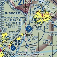
| Sectional chart |
|---|
|
CAUTION: Diagram may not be current
 Download PDF
of official airport diagram from the FAA
| Airport distance calculator |
|---|
|
|
| Sunrise and sunset |
|---|
|
Times for 20-Apr-2024
| | Local
(UTC-5) | | Zulu
(UTC) |
|---|
| Morning civil twilight | | 06:14 | | 11:14 |
| Sunrise | | 06:42 | | 11:42 |
| Sunset | | 20:09 | | 01:09 |
| Evening civil twilight | | 20:37 | | 01:37 |
|
| Current date and time |
|---|
| Zulu (UTC) | 20-Apr-2024 05:07:43 |
|---|
| Local (UTC-5) | 20-Apr-2024 00:07:43 |
|---|
|
| METAR |
|---|
| KMHK | 200452Z AUTO 03006KT 10SM SCT095 10/M02 A3032 RMK AO2 SLP269 T01001017
|
KFRI
8nm SW | 200355Z AUTO 02007KT 10SM OVC085 11/M02 A3032 RMK AO2 SLPNO T01131022 $
|
|
| TAF |
|---|
| KMHK | 191720Z 1918/2018 03005KT P6SM BKN150
|
KFRI
8nm SW | 191711Z 1917/2018 VRB03KT 9999 BKN120 QNH3021INS BECMG 1920/1921 04006KT 9999 SCT150 QNH3019INS TEMPO 2007/2011 9000 -SHRA OVC060 620009 BECMG 2010/2011 01008KT 9999 NSW BKN080 620805 QNH3035 TX15/1921Z TN06/2012Z LAST NO AMDS AFT 1921 NEXT 2212
|
|
| NOTAMs |
|---|
NOTAMs are issued by the DoD/FAA and will open in a separate window not controlled by AirNav.
|
|


