FAA INFORMATION EFFECTIVE 16 APRIL 2026
Location
| FAA Identifier: | N35 |
| Lat/Long: | 40-58-00.6120N 078-55-47.6560W
40-58.010200N 078-55.794267W
40.9668367,-78.9299044
(estimated) |
| Elevation: | 1444.8 ft. / 440 m (estimated) |
| Variation: | 10W (2005) |
| From city: | 3 miles NE of PUNXSUTAWNEY, PA |
| Time zone: | UTC -4 (UTC -5 during Standard Time) |
| Zip code: | 15767 |
Airport Operations
| Airport use: | Open to the public |
| Activation date: | 08/1945 |
| Control tower: | no |
| ARTCC: | CLEVELAND CENTER |
| FSS: | ALTOONA FLIGHT SERVICE STATION |
| NOTAMs facility: | AOO (NOTAM-D service available) |
| Attendance: | UNATTENDED
FOR SVC AFTER HRS CTC 814-590-1137. |
| Wind indicator: | lighted |
| Segmented circle: | yes |
| Lights: | ACTVT REIL RWY 1 & 19, 06 & 24; PAPI RWY 06 & 24; MIRL RWY 01/19 & 06/24 - CTAF. |
| Beacon: | white-green (lighted land airport)
Operates sunset to sunrise. |
Airport Communications
| CTAF/UNICOM: | 123.0 |
| WX ASOS at DUJ (13 nm N): | 119.025 (814-328-5140) |
- APCH/DEP SVC PRVDD BY CLEVELAND ARTCC (ZOB) ON FREQS 126.725/291.65 (DUBOIS RCAG).
Nearby radio navigation aids
| VOR radial/distance | | VOR name | | Freq | | Var |
|---|
| ETGr257/38.6 | | KEATING VORTAC | | 116.00 | | 10W |
| JSTr360/39.2 | | JOHNSTOWN VOR/DME | | 113.00 | | 06W |
Airport Services
| Fuel available: | 100LL
100LL:FUEL SELF-SERVE WITH CREDIT CARD. |
| Parking: | hangars and tiedowns |
| Airframe service: | NONE |
| Powerplant service: | NONE |
| Bottled oxygen: | NONE |
| Bulk oxygen: | NONE |
Runway Information
Runway 6/24
| Dimensions: | 3003 x 50 ft. / 915 x 15 m |
| Surface: | asphalt, in good condition |
| Weight bearing capacity: | |
| Runway edge lights: | medium intensity |
| RUNWAY 6 | | RUNWAY 24 |
| Latitude: | 40-57.872717N | | 40-58.143300N |
| Longitude: | 078-56.233967W | | 078-55.687817W |
| Elevation: | 1410.0 ft. | | 1437.0 ft. |
| Traffic pattern: | left | | left |
| Runway heading: | 067 magnetic, 057 true | | 247 magnetic, 237 true |
| Markings: | nonprecision, in good condition | | nonprecision, in good condition |
| Visual slope indicator: | 2-light PAPI on left (4.00 degrees glide path) | | 2-light PAPI on left (4.00 degrees glide path) |
| Runway end identifier lights: | yes | | yes |
| Touchdown point: | yes, no lights | | yes, no lights |
| Obstructions: | 32 ft. trees, 297 ft. from runway, 252 ft. right of centerline, 3:1 slope to clear
RWY 06 30 FT POLE, 103 FT FM RWY END, 227 FT RIGHT. | | 28 ft. road, 634 ft. from runway, 15:1 slope to clear |
Runway 1/19
| Dimensions: | 2200 x 100 ft. / 671 x 30 m |
| Surface: | turf, in fair condition |
| Runway edge lights: | medium intensity |
| Runway edge markings: | RWY MARKED WITH ORANGE CONES. |
| RUNWAY 1 | | RUNWAY 19 |
| Latitude: | 40-57.832000N | | 40-58.194333N |
| Longitude: | 078-55.565333W | | 078-55.568333W |
| Elevation: | 1436.0 ft. | | 1444.8 ft. |
| Traffic pattern: | left | | left |
| Runway heading: | 010 magnetic, 360 true | | 190 magnetic, 180 true |
| Markings: | NSTD, in good condition | | NSTD, in good condition |
| Runway end identifier lights: | yes | | yes |
| Touchdown point: | yes, no lights | | yes, no lights |
| Obstructions: | 67 ft. trees, 1001 ft. from runway, 178 ft. left of centerline, 14:1 slope to clear | | none |
Airport Ownership and Management from official FAA records
| Ownership: | Publicly-owned |
| Owner: | PUNXSUTAWNEY AIRPORT AUTH
PO BOX 365
PUNXSUTAWNEY, PA 15767
Phone (814) 590-1137 |
| Manager: | RICK YOUNG
PO BOX 365
PUNXSUTAWNEY, PA 15767
Phone (814) 590-1137 |
Additional Remarks
| - | TURF SOFT AND WET DRG SPRING THAW. |
| - | RWY 24 REIL IS ON A DAY SENSOR, OPER DURG HRS OF DARKNESS ONLY. |
| - | 56 FT STACK E OF RWY 01 |
| - | RWY 01/19 CLSD DEC-APR. |
| - | BIRDS; DEER & WOODCHUCK ON & INVOF ARPT. |
| - | RWY 19 22 FT ROAD 146 FT FM RWY END ACRS CNTRLN. |
| - | FOR CD CTC CLEVELAND ARTCC AT 440-774-0234. |
Instrument Procedures
NOTE: All procedures below are presented as PDF files. If you need a reader for these files, you should download the free Adobe Reader.NOT FOR NAVIGATION. Please procure official charts for flight.
FAA instrument procedures published for use from 16 April 2026 at 0901Z to 14 May 2026 at 0900Z.
IAPs - Instrument Approach Procedures |
|---|
| RNAV (GPS) RWY 24 | |
download (173KB) |
| NOTE: Special Take-Off Minimums/Departure Procedures apply | |
download (423KB) |
Other nearby airports with instrument procedures:
KDUJ - Dubois Regional Airport (13 nm N)
KIDI - Indiana County Airport (Jimmy Stewart Field) (22 nm S)
KFIG - Clearfield-Lawrence Airport (24 nm E)
KAXQ - Clarion County Airport (28 nm NW)
9G8 - Ebensburg Airport (31 nm S)
|
|

Road maps at:
MapQuest
Bing
Google
| Aerial photo |
|---|
WARNING: Photo may not be current or correct
 Photo taken 16-Aug-2010
looking South.
Photo taken 16-Aug-2010
looking South.
Do you have a better or more recent aerial photo of Punxsutawney Municipal Airport that you would like to share? If so, please send us your photo.
|
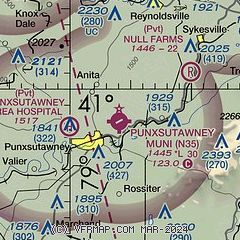
| Sectional chart |
|---|
|
| Airport distance calculator |
|---|
|
|
| Sunrise and sunset |
|---|
|
Times for 16-Apr-2026
| | Local
(UTC-4) | | Zulu
(UTC) |
|---|
| Morning civil twilight | | 06:08 | | 10:08 |
| Sunrise | | 06:36 | | 10:36 |
| Sunset | | 19:55 | | 23:55 |
| Evening civil twilight | | 20:24 | | 00:24 |
|
| Current date and time |
|---|
| Zulu (UTC) | 16-Apr-2026 22:41:48 |
|---|
| Local (UTC-4) | 16-Apr-2026 18:41:48 |
|---|
|
| METAR |
|---|
KDUJ
12nm N | 162207Z AUTO 30013G31KT 4SM -RA BR OVC080 17/15 A2986 RMK AO2 PK WND 26038/2156 WSHFT 2147 PRESRR P0002 T01720150
|
KIDI
22nm S | 162215Z AUTO 26019G24KT 10SM BKN075 OVC095 25/10 A2984 RMK A01
|
KFIG
24nm E | 161754Z AUTO 24014G24KT 10SM FEW060 27/12 A2987 RMK AO2 PK WND 23028/1738 SLP104 T02670117 10267 20139 57017
|
|
| TAF |
|---|
KDUJ
12nm N | 162147Z 1622/1718 23012G20KT P6SM BKN035 FM162205 27015G30KT 6SM -SHRA SCT030 BKN060 FM162310 27010KT P6SM -SHRA SCT030 BKN060 FM170500 27004KT P6SM SCT050 FM170800 26005KT P6SM BKN020 TEMPO 1710/1714 BKN010
|
|
| NOTAMs |
|---|
NOTAMs are issued by the DoD/FAA and will open in a separate window not controlled by AirNav.
|
|

