FAA INFORMATION EFFECTIVE 16 APRIL 2026
Location
| FAA Identifier: | N58 |
| Lat/Long: | 39-33-35.2587N 119-14-33.5634W
39-33.587645N 119-14.559390W
39.5597941,-119.2426565
(estimated) |
| Elevation: | 4346 ft. / 1325 m (estimated) |
| Variation: | 16E (1985) |
| From city: | 3 miles S of FERNLEY, NV |
| Time zone: | UTC -7 (UTC -8 during Standard Time) |
| Zip code: | 89408 |
Airport Operations
| Airport use: | Open to the public |
| Activation date: | 08/1991 |
| Control tower: | no |
| ARTCC: | OAKLAND CENTER |
| FSS: | RENO FLIGHT SERVICE STATION |
| NOTAMs facility: | RNO (NOTAM-D service available) |
| Attendance: | MON-FRI 0700-1900
MON-FRI |
| Wind indicator: | yes |
| Segmented circle: | yes |
| Beacon: | white-green (lighted land airport)
Operates sunset to sunrise. |
Airport Communications
| CTAF: | 122.9 |
| WX AWOS-2 at SPZ (9 nm S): | 120.475 (775-577-2624) |
Nearby radio navigation aids
| VOR radial/distance | | VOR name | | Freq | | Var |
|---|
| HZNr266/11.6 | | HAZEN VORTAC | | 114.10 | | 17E |
| FMGr069/19.2 | | MUSTANG VORTAC | | 117.90 | | 16E |
Airport Services
| Parking: | hangars and tiedowns |
Runway Information
Runway 15/33
| Dimensions: | 3974 x 40 ft. / 1211 x 12 m |
| Surface: | asphalt, in poor condition
2-4 FT DITCHES IN PRI SFC & RWY SAFETY AREA PARALLEL TO RWY 10 FT FM RWY EDGE. |
| Operational restrictions: | EFF GRADIENT 2 PERCENT S. |
| RUNWAY 15 | | RUNWAY 33 |
| Latitude: | 39-33.813440N | | 39-33.187913N |
| Longitude: | 119-14.513073W | | 119-14.264715W |
| Elevation: | 4278.4 ft. | | 4330.5 ft. |
| Traffic pattern: | right | | left |
| Runway heading: | 147 magnetic, 163 true | | 327 magnetic, 343 true |
| Markings: | numbers only, in fair condition | | numbers only, in fair condition |
| Touchdown point: | yes, no lights | | yes, no lights |
| Obstructions: | none | | 70 ft. hill, 1640 ft. from runway, 20:1 slope to clear
+4 FT FENCE 75 FT FM THR. |
Runway 5/23
| Dimensions: | 2750 x 30 ft. / 838 x 9 m |
| Surface: | gravel/dirt, in fair condition
MNT WET WX RWY CONDS - AMGR. |
| Operational restrictions: | EFF GRADIENT 4 PERCENT W; DEP RWY 05 & ARR RWY 23 DUE TO SLP. |
| RUNWAY 5 | | RUNWAY 23 |
| Latitude: | 39-33.619408N | | 39-33.807235N |
| Longitude: | 119-15.071987W | | 119-14.539553W |
| Elevation: | 4325.9 ft. | | 4280.2 ft. |
| Traffic pattern: | left | | left |
| Runway heading: | 050 magnetic, 066 true | | 230 magnetic, 246 true |
| Markings: | none, in poor condition | | none, in poor condition |
| Touchdown point: | yes, no lights | | yes, no lights |
| Obstructions: | 15 ft. road, 100 ft. from runway, 6:1 slope to clear | | 440 ft. hill, 2640 ft. from runway, 6:1 slope to clear |
Airport Ownership and Management from official FAA records
| Ownership: | Publicly-owned |
| Owner: | SAMSARG TF, LLC
GREG JOHNSON, MANAGER, 204 WEST SPEAR STREET
CARSON CITY, NV 89703
Phone 775-471-7301
BUREAU OF LAND MGMT - 775-861-6400 |
| Manager: | JOSH GRISWALD
PO BOX 283
SILVER SPRINGS, NV 89429
Phone 775-471-7302 |
Additional Remarks
| - | FOR CD CTC NORCAL APCH AT 916-361-0596. |
| - | ARPT FRQLY CLSD FOR MODEL ACFT; REMOTE ACFT OPS ON & INVOF ARPT; RDO USE ENCOURAGED. |
| - | HEL TRG RSTRD TO PAVED RWY ENDS; LIMIT TAXI & HOVER PRAC TO RAMP AREAS. |
| - | HORSE & CATTLE FRQLY ON & INVOF RWYS & TWYS. |
| - | 1740 FT OVRN NW OF RWY 15 END NOT ARPT PROPERTY; MAY BE MISTAKEN FOR DSPLCD THR. |
Instrument Procedures
There are no published instrument procedures at N58.
Some nearby airports with instrument procedures:
KSPZ - Silver Springs Airport (9 nm S)
KFLX - Fallon Municipal Airport (23 nm E)
KRNO - Reno/Tahoe International Airport (25 nm W)
KNFL - Fallon Naval Air Station (Van Voorhis Field) Airport (27 nm E)
KRTS - Reno/Stead Airport (30 nm W)
|
|

Road maps at:
MapQuest
Bing
Google
| Aerial photo |
|---|
WARNING: Photo may not be current or correct
 Photo by Bob Lenox
Do you have a better or more recent aerial photo of Samsarg Field Airport that you would like to share? If so, please send us your photo.
|
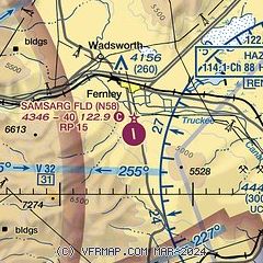
| Sectional chart |
|---|
|
| Airport distance calculator |
|---|
|
|
| Sunrise and sunset |
|---|
|
Times for 28-Apr-2026
| | Local
(UTC-7) | | Zulu
(UTC) |
|---|
| Morning civil twilight | | 05:34 | | 12:34 |
| Sunrise | | 06:02 | | 13:02 |
| Sunset | | 19:46 | | 02:46 |
| Evening civil twilight | | 20:15 | | 03:15 |
|
| Current date and time |
|---|
| Zulu (UTC) | 28-Apr-2026 09:09:21 |
|---|
| Local (UTC-7) | 28-Apr-2026 02:09:21 |
|---|
|
| TAF |
|---|
KRNO
25nm W | 280535Z 2806/2906 32006KT P6SM FEW060 SCT180 FM280700 VRB04KT P6SM SCT200 FM282300 36007KT P6SM SCT250 FM290200 31010KT P6SM SCT250
|
KNFL
27nm E | 280700Z 2807/2907 VRB06KT FEW050 SCT100 SCT200 QNH3001INS FM282100 03006KT SCT060 SCT100 SCT200 QNH3005INS AUTOMATED SENSOR METWATCH 2806 TIL 2813 TX19/2823Z TN02/2813Z FS30226
|
|
| NOTAMs |
|---|
NOTAMs are issued by the DoD/FAA and will open in a separate window not controlled by AirNav.
|
|

