FAA INFORMATION EFFECTIVE 30 OCTOBER 2025
Location
| FAA Identifier: | N63 |
| Lat/Long: | 36-18-05.4940N 080-08-54.1650W
36-18.091567N 080-08.902750W
36.3015261,-80.1483792
(estimated) |
| Elevation: | 631 ft. / 192.3 m (surveyed) |
| Variation: | 06W (1980) |
| From city: | 1 mile NW of WALNUT COVE, NC |
| Time zone: | UTC -5 (UTC -4 during Daylight Saving Time) |
| Zip code: | 27052 |
Airport Operations
| Airport use: | Open to the public |
| Activation date: | 09/1966 |
| Control tower: | no |
| ARTCC: | ATLANTA CENTER |
| FSS: | RALEIGH FLIGHT SERVICE STATION |
| NOTAMs facility: | RDU (NOTAM-D service available) |
| Attendance: | IRREGULAR |
| Wind indicator: | yes |
| Segmented circle: | no |
| Lights: | ACTVT LIRL RWY 16/34 - CTAF. |
Airport Communications
| CTAF/UNICOM: | 123.0 |
| GREENSBORO APPROACH: | 124.35 |
| GREENSBORO DEPARTURE: | 124.35 |
| WX ASOS at INT (11 nm S): | PHONE 336-661-3096 |
| WX ASOS at GSO (16 nm SE): | 128.55 (336-355-1608) |
| WX AWOS-3 at SIF (17 nm NE): | 119.775 (336-573-3677) |
Nearby radio navigation aids
| VOR radial/distance | | VOR name | | Freq | | Var |
|---|
| GSOr335/17.5 | | GREENSBORO VORTAC | | 116.20 | | 03W |
| LIBr322/39.2 | | LIBERTY VORTAC | | 113.00 | | 03W |
| NDB name | | Hdg/Dist | | Freq | | Var | | ID |
|---|
| SLAMMER | | 263/19.2 | | 423 | | 07W | | SIF | ... .. ..-. |
Airport Services
| Fuel available: | 100LL
100LL:100LL SELF SVC AVBL BY FBO. |
| Airframe service: | NONE |
| Powerplant service: | NONE |
Runway Information
Runway 16/34
| Dimensions: | 2725 x 32 ft. / 831 x 10 m |
| Surface: | asphalt, in good condition |
| Runway edge lights: | low intensity
NSTD LIRL; LGTS 30 FT EITHER SIDE OF ASPH ALONG OLD TURF RWY. NSTD THR LGTS WITH GREEN, RED, CLEAR AND BI-DIRECTIONAL LENS. |
| Runway edge markings: | MKGS FADED AND OBSCURED BY RWY SEALANT.
RWY MKNG SMALLER THAN NORMAL AND FADED; CNTRLN NSTD. |
| RUNWAY 16 | | RUNWAY 34 |
| Latitude: | 36-18.302500N | | 36-17.880500N |
| Longitude: | 080-08.997667W | | 080-08.807833W |
| Elevation: | 631.0 ft. | | 631.0 ft. |
| Traffic pattern: | left | | left |
| Runway heading: | 166 magnetic, 160 true | | 346 magnetic, 340 true |
| Markings: | NSTD, in poor condition | | NSTD, in poor condition |
| Touchdown point: | yes, no lights | | yes, no lights |
| Obstructions: | 39 ft. trees, 331 ft. from runway, 91 ft. right of centerline, 3:1 slope to clear
SCRUB TREES RANGING FROM 22 FT - 41 FT LCTD 0-200 FT FM THR OFFSET 100 FT RIGHT OF CNTRLN. | | 31 ft. trees, 372 ft. from runway, 164 ft. right of centerline, 5:1 slope to clear
+3 FT FENCE 30 FT FM THR BOTH SIDES OF CNTRLN. |
Airport Ownership and Management from official FAA records
| Ownership: | Privately-owned |
| Owner: | BIG CREEK PROPERTIES
3653 NORTH PATTERSON AVE
WINSTON-SALEM, NC 27105
Phone 336-661-8032 |
| Manager: | LOGAN FULP
1060 AIRPORT ROAD
WALNUT COVE, NC 27052
Phone 336-413-3967 |
Additional Remarks
| - | HIGH TRRN IN ALL QUADS. |
| - | NO TSNT TFC BEFORE DALGT OR AFT DARK. |
| - | +65 FT TREES WITHIN 110 FT OF CNTRLN EAST OF RWY. |
| - | FENCING IN THE CLEAR ZONE RWYS 16 & 34. |
| - | +8 FT DROP-OFF AREA RWY 16. |
| - | ARPT CLSD TO TSNTS EXCP PPR CALL 336-403-1796. |
| - | DO NOT LAND ON GRASS ADJ TO RWY. DEEP DITCHES. |
| - | FOR CD CTC GREENSBORO APCH AT 336-333-5119. |
| - | NO HEAVY TRNG TFC NO MORE THAN TWO TOUCH AND GOES AT ONE GIVEN TIME. |
Instrument Procedures
NOTE: All procedures below are presented as PDF files. If you need a reader for these files, you should download the free Adobe Reader.NOT FOR NAVIGATION. Please procure official charts for flight.
FAA instrument procedures published for use from 30 October 2025 at 0901Z to 27 November 2025 at 0900Z.
IAPs - Instrument Approach Procedures |
|---|
| VOR/DME OR GPS RWY 34 | |
download (182KB) |
| NOTE: Special Take-Off Minimums/Departure Procedures apply | |
download (357KB) |
Other nearby airports with instrument procedures:
KINT - Smith Reynolds Airport (11 nm S)
KGSO - Piedmont Triad International Airport (16 nm SE)
KSIF - Rockingham County NC Shiloh Airport (17 nm NE)
KMTV - Blue Ridge Airport (21 nm N)
KMWK - Mount Airy/Surry County Airport (22 nm NW)
|
|

Road maps at:
MapQuest
Bing
Google
| Aerial photo |
|---|
WARNING: Photo may not be current or correct

Do you have a better or more recent aerial photo of Meadow Brook Field Airport that you would like to share? If so, please send us your photo.
|
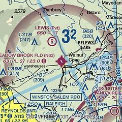
| Sectional chart |
|---|
|
| Airport distance calculator |
|---|
|
|
| Sunrise and sunset |
|---|
|
Times for 13-Nov-2025
| | Local
(UTC-5) | | Zulu
(UTC) |
|---|
| Morning civil twilight | | 06:29 | | 11:29 |
| Sunrise | | 06:57 | | 11:57 |
| Sunset | | 17:13 | | 22:13 |
| Evening civil twilight | | 17:40 | | 22:40 |
|
| Current date and time |
|---|
| Zulu (UTC) | 13-Nov-2025 18:10:04 |
|---|
| Local (UTC-5) | 13-Nov-2025 13:10:04 |
|---|
|
| METAR |
|---|
KINT
11nm S | 131754Z 29011G19KT 10SM CLR 17/M08 A3012 RMK AO2 SLP195 T01671078 10172 20078 58010
|
KGSO
15nm SE | 131754Z 30017G23KT 10SM BKN250 18/M06 A3010 RMK AO2 SLP188 T01781061 10178 20078 58012
|
KSIF
17nm NE | 131755Z AUTO 30006KT 10SM CLR 18/M05 A3010 RMK AO2 T01771054 10180 20055
|
KMTV
20nm N | 131755Z AUTO 32012G18KT 10SM CLR 16/M11 A3013 RMK AO2 T01631108 10163 20012
|
|
| TAF |
|---|
KINT
11nm S | 131738Z 1318/1418 31011G20KT P6SM BKN250 FM132200 31005KT P6SM SCT250 FM141500 24007KT P6SM SCT250
|
KGSO
15nm SE | 131738Z 1318/1418 31011G20KT P6SM BKN250 FM132200 30005KT P6SM SCT250 FM141500 24007KT P6SM SCT250
|
|
| NOTAMs |
|---|
NOTAMs are issued by the DoD/FAA and will open in a separate window not controlled by AirNav.
|
|

