FAA INFORMATION EFFECTIVE 11 JUNE 2026
Location
| FAA Identifier: | N92 |
| Lat/Long: | 35-34-27.4810N 081-07-02.2840W
35-34.458017N 081-07.038067W
35.5743003,-81.1173011
(estimated) |
| Elevation: | 1025 ft. / 312 m (estimated) |
| Variation: | 05W (1985) |
| From city: | 3 miles SE of MAIDEN, NC |
| Time zone: | UTC -4 (UTC -5 during Standard Time) |
| Zip code: | 28650 |
Airport Operations
| Airport use: | Open to the public |
| Activation date: | 08/1971 |
| Control tower: | no |
| ARTCC: | ATLANTA CENTER |
| FSS: | RALEIGH FLIGHT SERVICE STATION |
| NOTAMs facility: | RDU (NOTAM-D service available) |
| Attendance: | 0800 - DUSK |
| Wind indicator: | yes |
| Segmented circle: | no |
Airport Communications
| CTAF/UNICOM: | 122.8 |
| WX AWOS-3 at IPJ (6 nm S): | 119.675 (704-735-6954) |
| WX AWOS-3 at SVH (14 nm NE): | 119.225 (704-873-1978) |
| WX ASOS at HKY (17 nm NW): | 118.325 (828-322-2996) |
Nearby radio navigation aids
| VOR radial/distance | | VOR name | | Freq | | Var |
|---|
| BZMr167/18.7 | | BARRETTS MOUNTAIN VOR/DME | | 113.75 | | 06W |
| CLTr346/24.4 | | CHARLOTTE VOR/DME | | 115.00 | | 05W |
| NDB name | | Hdg/Dist | | Freq | | Var | | ID |
|---|
| STONIA | | 011/23.1 | | 260 | | 06W | | GHJ | --. .... .--- |
| FIDDLERS | | 114/28.2 | | 391 | | 07W | | FIQ | ..-. .. --.- |
Airport Services
| Parking: | tiedowns |
| Airframe service: | NONE |
| Powerplant service: | NONE |
| Bottled oxygen: | NONE |
| Bulk oxygen: | NONE |
Runway Information
Runway 13/31
| Dimensions: | 2400 x 75 ft. / 732 x 23 m |
| Surface: | turf, in good condition |
| RUNWAY 13 | | RUNWAY 31 |
| Traffic pattern: | left | | left |
| Obstructions: | 65 ft. trees, 34 ft. from runway, 45 ft. right of centerline
CTLG OBSTN EXCEEDS A 45 DEG SLP. | | 79 ft. trees, 268 ft. from runway, 15 ft. left of centerline, 3:1 slope to clear |
Runway 5/23
| Dimensions: | 2000 x 100 ft. / 610 x 30 m |
| Surface: | turf, in good condition |
| Runway edge markings: | RWY 05/23 NRS SMALLER THAN STD. |
| RUNWAY 5 | | RUNWAY 23 |
| Traffic pattern: | left | | left |
| Markings: | NSTD, in good condition | | NSTD, in good condition |
| Obstructions: | 30 ft. pline, 1 ft. from runway, 80 ft. right of centerline
CTLG OBSTN EXCEEDS A 45 DEG SLP. | | 35 ft. pline, 45 ft. from runway, 1:1 slope to clear |
Airport Ownership and Management from official FAA records
| Ownership: | Privately-owned |
| Owner: | CHARLES LANEY
4235 POOL VIEW DR
MAIDEN, NC 28650
Phone 828-428-8939 |
| Manager: | CHARLES LANEY
4235 POOL VIEW DR
MAIDEN, NC 28650
Phone (828) 312-6189
MGR'S CELL PHONE 828-312-6189. |
Additional Remarks
| - | RWY 05 & RWY 13 FOR PREF LDG (UPHILL). |
| - | RWY 05 & RWY 31 BOTH HAVE UNMKD PLINES ACRS RWY THLDS. RWY 23 HAS MKD PLINES ACRS RWY THLD. |
| - | ULTRALIGHT ACFT OPRG ON AND INVOF ARPT. |
| - | RWY 13 HAS NO LINE OF SIGHT FM RWY END. |
| - | FOR CD CTC CHARLOTTE APCH AT 704-359-0241. |
| - | SKYDIVING WKEND ACTS ON AND INVOF ARPT. |
| - | RWY 13 - FIRST 200 FEET FROM THLD IS NOT MNTND AND IS NOT USBL. |
Instrument Procedures
There are no published instrument procedures at N92.
Some nearby airports with instrument procedures:
KIPJ - Lincoln County Regional Airport (6 nm S)
14A - Lake Norman Airpark (11 nm E)
KSVH - Statesville Regional Airport (14 nm NE)
KHKY - Hickory Regional Airport (17 nm NW)
KAKH - Gastonia Municipal Airport (22 nm S)
|
|

Road maps at:
MapQuest
Bing
Google
| Aerial photo |
|---|
WARNING: Photo may not be current or correct
 Photo by Jack Wysong, Hickory, NC
Do you have a better or more recent aerial photo of Laneys Airport that you would like to share? If so, please send us your photo.
|
| Sectional chart |
|---|
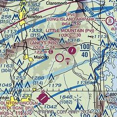
|
| Airport distance calculator |
|---|
|
|
| Sunrise and sunset |
|---|
|
Times for 11-Jun-2026
| | Local
(UTC-4) | | Zulu
(UTC) |
|---|
| Morning civil twilight | | 05:39 | | 09:39 |
| Sunrise | | 06:09 | | 10:09 |
| Sunset | | 20:39 | | 00:39 |
| Evening civil twilight | | 21:09 | | 01:09 |
|
| Current date and time |
|---|
| Zulu (UTC) | 11-Jun-2026 11:18:52 |
|---|
| Local (UTC-4) | 11-Jun-2026 07:18:52 |
|---|
|
| METAR |
|---|
KIPJ
6nm SW | 111055Z AUTO 00000KT 3SM BR SCT075 21/20 A3002 RMK AO2 T02050202
|
KSVH
13nm NE | 111055Z AUTO 23003KT 10SM BKN060 21/21 A3002 RMK AO2 T02140213
|
KHKY
17nm NW | 111053Z 00000KT M1/4SM FG VV001 21/21 A3002 RMK AO2 SLP144 T02060206 $
|
|
| TAF |
|---|
KHKY
17nm NW | 110950Z 1110/1206 VRB03KT 1SM BR BKN005 TEMPO 1110/1112 1/4SM FG VV001 FM111300 VRB03KT P6SM SCT250 FM111600 21005KT P6SM SCT050 BKN250 PROB30 1119/1123 4SM TSRA BR BKN025CB FM120100 VRB02KT P6SM SCT250
|
|
| NOTAMs |
|---|
NOTAMs are issued by the DoD/FAA and will open in a separate window not controlled by AirNav.
|
|

