FAA INFORMATION EFFECTIVE 14 MAY 2026
Location
| FAA Identifier: | N96 |
| Lat/Long: | 40-53-07.8000N 077-48-58.4000W
40-53.130000N 077-48.973333W
40.8855000,-77.8162222
(estimated) |
| Elevation: | 1071.5 ft. / 326.6 m (surveyed) |
| Variation: | 10W (1990) |
| From city: | 3 miles SW of BELLEFONTE, PA |
| Time zone: | UTC -4 (UTC -5 during Standard Time) |
| Zip code: | 16823 |
Airport Operations
| Airport use: | Open to the public |
| Activation date: | 08/1971 |
| Control tower: | no |
| ARTCC: | NEW YORK CENTER |
| FSS: | ALTOONA FLIGHT SERVICE STATION |
| NOTAMs facility: | AOO (NOTAM-D service available) |
| Attendance: | 0800-DUSK
FOR SVC AFT HRS CTC 814-355-7407 OR 814-883-7646. |
| Pattern altitude: | 2100.5 ft. MSL |
| Wind indicator: | yes |
| Segmented circle: | no |
| Lights: | ACTVT PAPI RWY 25; LIRL RWY 07/25 - 122.7. |
| Beacon: | white-green (lighted land airport)
ACTVT ARPT BCN - 122.7. |
Airport Communications
| CTAF/UNICOM: | 122.8 |
| CLEARANCE DELIVERY: | 125.725 |
| WX AWOS-3 at UNV (2.6 nm SW): | 127.65 (814-865-8799) |
| WX AWOS-3 at PSB (12 nm W): | 127.525 (814-343-4531) |
| WX AWOS-3PT at RVL (15 nm SE): | 123.85 (717-667-3993) |
- APCH/DEP SVC PRVDD BY NEW YORK ARTCC ON FREQS 134.8/338.3 (PHILIPSBURG RCAG).
- CLEARANCE DELIVERY PVDD BY NEW YORK ARTCC ON FREQ 118.55 WHEN UNV TWR CLSD.
Nearby radio navigation aids
| VOR radial/distance | | VOR name | | Freq | | Var |
|---|
| PSBr113/8.2 | | PHILIPSBURG VORTAC | | 115.50 | | 10W |
| ETGr153/24.7 | | KEATING VORTAC | | 116.00 | | 10W |
| SLTr178/38.3 | | SLATE RUN VORTAC | | 113.90 | | 08W |
Airport Services
| Fuel available: | 100LL JET-A |
| Parking: | hangars and tiedowns |
| Airframe service: | MAJOR |
| Powerplant service: | MAJOR |
| Bottled oxygen: | NONE |
| Bulk oxygen: | NONE |
Runway Information
Runway 7/25
| Dimensions: | 3632 x 60 ft. / 1107 x 18 m |
| Surface: | asphalt, in fair condition |
| Runway edge lights: | non-standard
RWY 25 THR LGTS LCTD 43 FT PAST RWY THR MKG. |
| Runway edge markings: | RWY MARKINGS EXTREMELY FADED. |
| RUNWAY 7 | | RUNWAY 25 |
| Latitude: | 40-52.964932N | | 40-53.295927N |
| Longitude: | 077-49.302030W | | 077-48.645692W |
| Elevation: | 1068.9 ft. | | 1057.4 ft. |
| Traffic pattern: | left | | right |
| Runway heading: | 066 magnetic, 056 true | | 246 magnetic, 236 true |
| Markings: | nonprecision, in poor condition | | nonprecision, in poor condition |
| Visual slope indicator: | | | 2-light PAPI on left (3.50 degrees glide path) |
| Touchdown point: | yes, no lights | | yes, no lights |
| Obstructions: | 34 ft. tree, 278 ft. from runway, 233 ft. right of centerline, 2:1 slope to clear | | none |
Airport Ownership and Management from official FAA records
| Ownership: | Privately-owned |
| Owner: | MARINA ELNITSKI
225 SNOWBIRD LA
BELLEFONTE, PA 16823
Phone 814-355-7407 |
| Manager: | JOHN ELNITSKI
225 SNOWBIRD LA
BELLEFONTE, PA 16823
Phone 814-355-7407 |
Additional Remarks
| - | ULTRA-LIGHTS ON & INVOF ARPT. |
| - | ALL HELI RQRD TO USE FIXED WING TFC PAT. |
| - | HVY GLIDER ACT DURG DALGT HRS, ALL ALTS WI 10 NM AREA, ALL DRCTNS, SPCLY ALG RIDGE 1 NM WEST & NORTH OF ARPT. |
| - | CTC UNV TWR(UNIVERSITY PARK) 128.475 PRIOR TO ENTERING CLASS D ASP. |
Instrument Procedures
NOTE: All procedures below are presented as PDF files. If you need a reader for these files, you should download the free Adobe Reader.NOT FOR NAVIGATION. Please procure official charts for flight.
FAA instrument procedures published for use from 14 May 2026 at 0901Z to 11 June 2026 at 0900Z.
IAPs - Instrument Approach Procedures |
|---|
| RNAV (GPS) RWY 07 | |
download (206KB) |
| RNAV (GPS) RWY 25 | |
download (226KB) |
| NOTE: Special Take-Off Minimums/Departure Procedures apply | |
download (152KB) |
Other nearby airports with instrument procedures:
KUNV - State College Regional Airport (3 nm SW)
KPSB - Mid-State Airport (12 nm W)
KRVL - Mifflin County Airport (15 nm SE)
KLHV - William T Piper Memorial Airport (23 nm NE)
P34 - Mifflintown Airport (25 nm SE)
|
|

Road maps at:
MapQuest
Bing
Google
| Aerial photo |
|---|
WARNING: Photo may not be current or correct
 Photo taken 07-Oct-2011
looking west.
Photo taken 07-Oct-2011
looking west.
Do you have a better or more recent aerial photo of Bellefonte Airport that you would like to share? If so, please send us your photo.
|
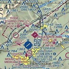
| Sectional chart |
|---|
|
| Airport distance calculator |
|---|
|
|
| Sunrise and sunset |
|---|
|
Times for 07-Jun-2026
| | Local
(UTC-4) | | Zulu
(UTC) |
|---|
| Morning civil twilight | | 05:08 | | 09:08 |
| Sunrise | | 05:41 | | 09:41 |
| Sunset | | 20:39 | | 00:39 |
| Evening civil twilight | | 21:13 | | 01:13 |
|
| Current date and time |
|---|
| Zulu (UTC) | 07-Jun-2026 06:13:36 |
|---|
| Local (UTC-4) | 07-Jun-2026 02:13:36 |
|---|
|
| METAR |
|---|
KUNV
2nm S | 070555Z AUTO 00000KT 10SM CLR 18/18 A2988 RMK AO2 T01830183 10211 20180
|
KRVL
15nm SE | 070555Z AUTO 00000KT 6SM BR FEW090 18/17 A2987 RMK AO2
|
|
| TAF |
|---|
KUNV
2nm S | 070521Z 0706/0806 22004KT P6SM BKN050 FM070800 26002KT P6SM SCT050 TEMPO 0709/0711 4SM BR FM071500 30011G19KT P6SM SCT050 FM072200 02004KT P6SM SKC
|
|
| NOTAMs |
|---|
NOTAMs are issued by the DoD/FAA and will open in a separate window not controlled by AirNav.
|
|

