FAA INFORMATION EFFECTIVE 25 DECEMBER 2025
Location
| FAA Identifier: | UNV |
| Lat/Long: | 40-51-00.0000N 077-50-51.3000W
40-51.000000N 077-50.855000W
40.8500000,-77.8475833
(estimated) |
| Elevation: | 1231.3 ft. / 375 m (estimated) |
| Variation: | 11W (2000) |
| From city: | 3 miles N of STATE COLLEGE, PA |
| Time zone: | UTC -5 (UTC -4 during Daylight Saving Time) |
| Zip code: | 16803 |
Airport Operations
| Airport use: | Open to the public |
| Activation date: | 03/1959 |
| Control tower: | yes |
| ARTCC: | NEW YORK CENTER |
| FSS: | ALTOONA FLIGHT SERVICE STATION |
| NOTAMs facility: | UNV (NOTAM-D service available) |
| Attendance: | CONTINUOUS |
| Pattern altitude: | TRAFFIC PATTERN ALTITUDE FOR SINGLE ENGINE ACRFT 961 FT; MULTI ENGINE ACRFT 1461 FT. |
| Wind indicator: | lighted |
| Segmented circle: | yes |
| Lights: | WHEN ATCT CLSD ACTVT MALSR RWY 24; REIL RWY 06; HIRL RWY 06/24 & TWY LGTS - CTAF. |
| Beacon: | white-green (lighted land airport)
Operates sunset to sunrise. |
| Landing fee: | yes, LNDG FEE FOR SNGL ENG, MULTI ENG ACFT & HELICOPTERS. SPL EVENT FEE FOR SNGL ENG, MULTI ENG ACFT & HELICOPTERS ON UNIVERSITY HOME FOOTBALL GAME WKENDS. |
| Fire and rescue: | ARFF index B |
| Airline operations: | PPR 24 HRS FOR UNSKED ACR OPS WITH MORE THAN 9 PAX SEATS BTN 0400-0900Z CALL AMGR. |
Airport Communications
| CTAF: | 128.475 |
| UNICOM: | 122.95 |
| WX AWOS-3: | 127.65 (814-865-8799) |
| UNIVERSITY PARK GROUND: | 125.725 [0600-2200] |
| UNIVERSITY PARK TOWER: | 128.475 [0600-2200] |
| CLEARANCE DELIVERY: | 125.725 |
| D-ATIS: | 127.65 |
| WX AWOS-3 at PSB (11 nm W): | 127.525 (814-343-4531) |
| WX AWOS-3PT at RVL (14 nm SE): | 123.85 (717-667-3993) |
- APCH/DEP SVC PRVDD BY NEW YORK ARTCC ON FREQS 134.8/338.3 (PHILIPSBURG RCAG) WHEN TWR CLSD.
- CLEARANCE DELIVERY PVDD BY NEW YORK ARTCC ON FREQ 118.55 WHEN TWR CLSD.
Nearby radio navigation aids
| VOR radial/distance | | VOR name | | Freq | | Var |
|---|
| PSBr131/7.7 | | PHILIPSBURG VORTAC | | 115.50 | | 10W |
| ETGr159/25.7 | | KEATING VORTAC | | 116.00 | | 10W |
Airport Services
| Fuel available: | 100LL JET-A |
| Parking: | hangars and tiedowns |
| Airframe service: | MAJOR |
| Powerplant service: | MINOR |
| Bottled oxygen: | LOW |
| Bulk oxygen: | NONE |
Runway Information
Runway 6/24
| Dimensions: | 6701 x 150 ft. / 2042 x 46 m |
| Surface: | asphalt/grooved, in good condition
GRVD PORTION OF RY CTR 80 FT. |
| Weight bearing capacity: | | Single wheel: | 50.0 | | Double wheel: | 110.0 |
|
| Runway edge lights: | high intensity |
| RUNWAY 6 | | RUNWAY 24 |
| Latitude: | 40-50.666747N | | 40-51.334658N |
| Longitude: | 077-51.433492W | | 077-50.276808W |
| Elevation: | 1231.2 ft. | | 1191.8 ft. |
| Traffic pattern: | right | | left |
| Runway heading: | 064 magnetic, 053 true | | 244 magnetic, 233 true |
| Declared distances: | TORA:6701 TODA:6701 ASDA:6701 LDA:6701 | | TORA:6701 TODA:6701 ASDA:6701 LDA:6701 |
| Markings: | precision, in good condition | | precision, in good condition |
| Visual slope indicator: | 4-light PAPI on left (3.00 degrees glide path) | | 4-light PAPI on right (3.00 degrees glide path) |
| RVR equipment: | rollout | | touchdown |
| Approach lights: | | | MALSR: 1,400 foot medium intensity approach lighting system with runway alignment indicator lights |
| Runway end identifier lights: | yes | | |
| Touchdown point: | yes, no lights | | yes, no lights |
| Instrument approach: | | | ILS/DME |
| Obstructions: | none | | 86 ft. trees, 2745 ft. from runway, 106 ft. left of centerline, 29:1 slope to clear |
Airport Ownership and Management from official FAA records
| Ownership: | Publicly-owned |
| Owner: | PENN STATE UNIVERSITY
2535 FOX HILL RD
STATE COLLEGE, PA 16803
Phone 814-865-4042 |
| Manager: | BRYAN RODGERS
2535 FOX HILL RD
STATE COLLEGE, PA 16803
Phone 814-865-4042 |
Additional Remarks
| A39-06/24 | PCR VALUE: 600/F/C/X/T |
| - | 35 FT AGL LGT POLES ON THE N EDGE OF DEICE APN. |
| - | AIR CGO APRN RSTD TO ACFT LESS THAN 12500 LBS. |
| - | ACFT ON EITHER END RWY 06/24 CANNOT BE SEEN ON OTHER END DUE TO RWY GRADE. |
| - | STUDENT TRAINING 2.5 NM NE AT BELLEFONTE ARPT. |
| - | DEICING EQUIP AVBL ON APN ADJ TO TWY B BTN TWYS D & B3. |
Instrument Procedures
NOTE: All procedures below are presented as PDF files. If you need a reader for these files, you should download the free Adobe Reader.NOT FOR NAVIGATION. Please procure official charts for flight.
FAA instrument procedures published for use from 25 December 2025 at 0901z to 22 January 2026 at 0900z.
IAPs - Instrument Approach Procedures |
|---|
| ILS OR LOC RWY 24 | |
download (256KB) |
| RNAV (GPS) RWY 06 | |
download (240KB) |
| RNAV (GPS) RWY 24 | |
download (257KB) |
| NOTE: Special Alternate Minimums apply | |
download (145KB) |
| NOTE: Special Take-Off Minimums/Departure Procedures apply | |
download (424KB) |
Other nearby airports with instrument procedures:
N96 - Bellefonte Airport (3 nm NE)
KPSB - Mid-State Airport (11 nm W)
KRVL - Mifflin County Airport (14 nm SE)
P34 - Mifflintown Airport (25 nm SE)
KLHV - William T Piper Memorial Airport (26 nm NE)
|
|

Road maps at:
MapQuest
Bing
Google
| Aerial photo |
|---|
WARNING: Photo may not be current or correct
 Photo by Walter Mong
Taken in June 2012
looking northeast.
Photo by Walter Mong
Taken in June 2012
looking northeast.
Do you have a better or more recent aerial photo of State College Regional Airport that you would like to share? If so, please send us your photo.
|
| Sectional chart |
|---|
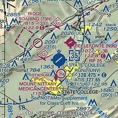
|
| Airport distance calculator |
|---|
|
|
| Sunrise and sunset |
|---|
|
Times for 01-Jan-2026
| | Local
(UTC-5) | | Zulu
(UTC) |
|---|
| Morning civil twilight | | 07:06 | | 12:06 |
| Sunrise | | 07:37 | | 12:37 |
| Sunset | | 16:53 | | 21:53 |
| Evening civil twilight | | 17:24 | | 22:24 |
|
| Current date and time |
|---|
| Zulu (UTC) | 01-Jan-2026 22:52:55 |
|---|
| Local (UTC-5) | 01-Jan-2026 17:52:55 |
|---|
|
| METAR |
|---|
| KUNV | 012153Z 29009KT 10SM SCT040 M08/M16 A2984
|
KRVL
14nm SE | 012235Z AUTO 27007G15KT 240V320 10SM CLR M07/M16 A2988 RMK AO2
|
|
| TAF |
|---|
| KUNV | 011732Z 0118/0218 29010G18KT P6SM BKN035 FM012300 27007KT P6SM SCT040 BKN100 FM020200 26007KT P6SM OVC050 FM021500 28011G20KT P6SM BKN050
|
|
| NOTAMs |
|---|
NOTAMs are issued by the DoD/FAA and will open in a separate window not controlled by AirNav.
|
|


