FAA INFORMATION EFFECTIVE 15 MAY 2025
Location
| FAA Identifier: | OIC |
| Lat/Long: | 42-33-59.6000N 075-31-26.8000W
42-33.993333N 075-31.446667W
42.5665556,-75.5241111
(estimated) |
| Elevation: | 1024.4 ft. / 312.2 m (surveyed) |
| Variation: | 11W (1965) |
| From city: | 2 miles N of NORWICH, NY |
| Time zone: | UTC -4 (UTC -5 during Standard Time) |
| Zip code: | 13815 |
Airport Operations
| Airport use: | Open to the public |
| Activation date: | 02/1940 |
| Control tower: | no |
| ARTCC: | BOSTON CENTER |
| FSS: | BUFFALO FLIGHT SERVICE STATION |
| NOTAMs facility: | OIC (NOTAM-D service available) |
| Attendance: | MON-FRI 0700-1500
UNATNDD CHRISTMAS. |
| Wind indicator: | lighted |
| Segmented circle: | yes |
| Lights: | ACTVT REIL RWY 19; PAPI RWY 01 & 19; HIRL RWY 01/19 - CTAF. |
| Beacon: | white-green (lighted land airport)
Operates sunset to sunrise. |
| Landing fee: | no, OVNGT TIE-DOWN FEE; FEE WAIVED WITH FUEL PURCHASE. |
Airport Communications
| CTAF/UNICOM: | 122.8 |
| WX AWOS-3: | 119.025 (607-336-8583) |
| WX AWOS-3 at N23 (17 nm S): | 118.275 (607-561-2333) |
| WX AWOS-3P at VGC (17 nm N): | 119.425 (315-824-1825) |
- APCH/DEP SVC PRVDD BY BOSTON ARTCC ON FREQS 133.25/279.5 (ROCKDALE RCAG).
Nearby radio navigation aids
| VOR radial/distance | | VOR name | | Freq | | Var |
|---|
| RKAr307/14.0 | | ROCKDALE VOR/DME | | 112.60 | | 11W |
| HNKr354/31.6 | | HANCOCK VOR/DME | | 116.80 | | 11W |
| DNYr324/34.3 | | DELANCEY VOR/DME | | 112.10 | | 11W |
| CFBr058/36.6 | | BINGHAMTON VOR/DME | | 112.20 | | 10W |
Airport Services
| Fuel available: | 100LL JET-A JET-A+
100LL:SELF-SVC FUEL AVBL 24/7 WITH CREDIT CARD. |
| Parking: | hangars and tiedowns |
| Airframe service: | NONE |
| Powerplant service: | NONE |
| Bottled oxygen: | NONE |
| Bulk oxygen: | NONE |
Runway Information
Runway 1/19
| Dimensions: | 4727 x 75 ft. / 1441 x 23 m |
| Surface: | asphalt/grooved, in good condition |
| Weight bearing capacity: | | PCN 14 /F/A/X/T | | Single wheel: | 48.5 | | Double wheel: | 68.0 |
|
| Runway edge lights: | high intensity |
| RUNWAY 1 | | RUNWAY 19 |
| Latitude: | 42-33.604827N | | 42-34.382215N |
| Longitude: | 075-31.470463W | | 075-31.423007W |
| Elevation: | 1009.0 ft. | | 1024.2 ft. |
| Traffic pattern: | left | | left |
| Runway heading: | 014 magnetic, 003 true | | 194 magnetic, 183 true |
| Displaced threshold: | 275 ft. | | 333 ft. |
| Declared distances: | TORA:4727 TODA:4727 ASDA:4394 LDA:4119 | | TORA:4727 TODA:4727 ASDA:4452 LDA:4119 |
| Markings: | nonprecision, in good condition | | nonprecision, in fair condition |
| Visual slope indicator: | 2-light PAPI on left (4.00 degrees glide path)
UNUSBL BYD 4 DEGS LEFT OF CNTRLN. | | 2-light PAPI on left (3.75 degrees glide path)
UNUSBL BYD 3 NM AND BYD 4 DEGS LEFT OF CNTRLN. |
| Runway end identifier lights: | no | | yes |
| Touchdown point: | yes, no lights | | yes, no lights |
| Obstructions: | 41 ft. trees, 502 ft. from runway, 18 ft. right of centerline, 7:1 slope to clear
RWY 01 46 FT TREES, 0-200 FT FM RWY END, 222 FT RIGHT OF CNTRLN. | | 19 ft. road, 301 ft. from runway, 134 ft. left of centerline, 5:1 slope to clear
RWY 19 +6 FT TREE 154 FT FM RWY END 75 FT RIGHT. |
Airport Ownership and Management from official FAA records
| Ownership: | Publicly-owned |
| Owner: | CHENANGO COUNTY
5 COURT ST.
NORWICH, NY 13815
Phone 607-337-1640 |
| Manager: | SHANE H. BUTLER
6390 STATE HWY 12
NORWICH, NY 13815
Phone 607-334-9430 |
Additional Remarks
| - | NUMEROUS MTNS PIERCE CONICAL SFC AROUND ARPT. |
| - | RY 19 HAS 15 FT DROPOFF 30 FT FM THLD ON WEST SIDE. |
| - | RY SAFETY AREAS HAVE DEPRESSIONS IN SFC. |
| - | GEESE & DEER ON & INVOF ARPT. |
| - | FOR CD CTC BOSTON ARTCC AT 603-879-6859. |
| - | COLD TEMPERATURE AIRPORT. ALTITUDE CORRECTION REQUIRED AT OR BELOW -24C. |
Instrument Procedures
NOTE: All procedures below are presented as PDF files. If you need a reader for these files, you should download the free Adobe Reader.NOT FOR NAVIGATION. Please procure official charts for flight.
FAA instrument procedures published for use from 15 May 2025 at 0901Z to 13 June 2025 at 0900z.
IAPs - Instrument Approach Procedures |
|---|
| RNAV (GPS) RWY 01 | |
download (245KB) |
| RNAV (GPS) RWY 19 | |
download (235KB) |
| NOTE: Special Take-Off Minimums/Departure Procedures apply | |
download (255KB) |
Other nearby airports with instrument procedures:
N23 - Sidney Municipal Airport (17 nm S)
KVGC - Hamilton Municipal Airport (17 nm N)
N66 - Albert S Nader Regional Airport (20 nm E)
KBGM - Greater Binghamton Airport/Edwin A Link Field (29 nm SW)
N03 - Cortland County Airport-Chase Field (31 nm W)
|
|

Road maps at:
MapQuest
Bing
Google
| Aerial photo |
|---|
WARNING: Photo may not be current or correct
 Photo taken 13-Mar-2016
looking south
Photo taken 13-Mar-2016
looking south
Do you have a better or more recent aerial photo of LT Warren Eaton Airport that you would like to share? If so, please send us your photo.
|
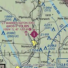
| Sectional chart |
|---|
|
| Airport distance calculator |
|---|
|
|
| Sunrise and sunset |
|---|
|
Times for 25-May-2025
| | Local
(UTC-4) | | Zulu
(UTC) |
|---|
| Morning civil twilight | | 04:59 | | 08:59 |
| Sunrise | | 05:32 | | 09:32 |
| Sunset | | 20:26 | | 00:26 |
| Evening civil twilight | | 20:59 | | 00:59 |
|
| Current date and time |
|---|
| Zulu (UTC) | 25-May-2025 17:25:07 |
|---|
| Local (UTC-4) | 25-May-2025 13:25:07 |
|---|
|
| METAR |
|---|
| KOIC | 251655Z AUTO 34011G16KT 10SM BKN032 BKN039 OVC060 13/06 A3012 RMK AO2
|
KVGC
17nm N | 251655Z AUTO 28006G14KT 10SM SCT027 SCT038 BKN055 13/07 A3013 RMK AO2
|
|
| TAF |
|---|
KBGM
29nm SW | 251246Z 2513/2612 30008G15KT P6SM SCT009 OVC015 TEMPO 2513/2515 BKN009 FM251600 31010G17KT P6SM BKN021 FM251800 31009G16KT P6SM BKN045 FM252300 30004KT P6SM SCT029 FM260900 30004KT P6SM BKN012
|
|
| NOTAMs |
|---|
NOTAMs are issued by the DoD/FAA and will open in a separate window not controlled by AirNav.
|
|


