FAA INFORMATION EFFECTIVE 11 JUNE 2026
Location
| FAA Identifier: | N03 |
| Lat/Long: | 42-35-33.5100N 076-12-53.5780W
42-35.558500N 076-12.892967W
42.5926417,-76.2148828
(estimated) |
| Elevation: | 1197.3 ft. / 364.9 m (surveyed) |
| Variation: | 13W (2000) |
| From city: | 2 miles SW of CORTLAND, NY |
| Time zone: | UTC -4 (UTC -5 during Standard Time) |
| Zip code: | 13045 |
Airport Operations
| Airport use: | Open to the public |
| Activation date: | 02/1940 |
| Control tower: | no |
| ARTCC: | BOSTON CENTER |
| FSS: | BUFFALO FLIGHT SERVICE STATION |
| NOTAMs facility: | N03 (NOTAM-D service available) |
| Attendance: | MON-FRI 0700-1530
UNATNDD HOLIDAYS, OTR HRS CALL ARPT MGR. |
| Wind indicator: | lighted |
| Segmented circle: | yes |
| Lights: | ACTVT REIL RWY 24; PAPI RWY 06 & 24; MIRL RWY 06/24; TWY LGTS - CTAF. |
| Beacon: | white-green (lighted land airport)
Operates sunset to sunrise. |
Airport Communications
| CTAF/UNICOM: | 122.8 |
| WX AWOS-3: | 132.225 (607-753-9784) |
| ELMIRA APPROACH: | 118.6 ;S-SE 124.3 ;W 126.125 |
| SYRACUSE DEPARTURE: | 126.125 |
| WX AWOS-3PT at ITH (12 nm SW): | 125.175 (607-697-7959) |
- APCH SVC PRVDD BY NEW YORK ARTCC ON FREQS 133.35/372.0 (SAYRE RCAG) WHEN ELMIRA APCH CTL AND BINGHAMTON APCH CTL CLSD.
- APPROACHES FROM THE NORTH USE SYRACUSE APCH 126.125/269.125.APPROACHES FROM THE SOUTH-SOUTH EAST USE BINGHAMTON APCH 118.6/257.625.APPROACHES FROM THE WEST USE ELMIRA APCH 124.3/257.8.
Nearby radio navigation aids
| VOR radial/distance | | VOR name | | Freq | | Var |
|---|
| CFBr002/26.3 | | BINGHAMTON VOR/DME | | 112.20 | | 10W |
| SYRr192/34.1 | | SYRACUSE VORTAC | | 117.00 | | 11W |
| NDB name | | Hdg/Dist | | Freq | | Var | | ID |
|---|
| ALPINE | | 061/32.3 | | 245 | | 12W | | ALP | .- .-.. .--. |
Airport Services
| Fuel available: | 100LL JET-A+
100LL:SELF SVC AVBL 24 HRS WITH CREDIT CARD.
A+:SELF SVC AVBL 24 HRS WITH CREDIT CARD. |
| Parking: | hangars and tiedowns |
| Airframe service: | MAJOR |
| Powerplant service: | MAJOR |
| Bottled oxygen: | NONE |
| Bulk oxygen: | NONE |
Runway Information
Runway 6/24
| Dimensions: | 3401 x 75 ft. / 1037 x 23 m |
| Surface: | asphalt/grooved, in good condition |
| Weight bearing capacity: | |
| Runway edge lights: | medium intensity |
| RUNWAY 6 | | RUNWAY 24 |
| Latitude: | 42-35.365178N | | 42-35.751815N |
| Longitude: | 076-13.166960W | | 076-12.618942W |
| Elevation: | 1197.3 ft. | | 1163.9 ft. |
| Traffic pattern: | left | | left |
| Runway heading: | 059 magnetic, 046 true | | 239 magnetic, 226 true |
| Markings: | nonprecision, in good condition | | nonprecision, in good condition |
| Visual slope indicator: | 2-light PAPI on left (4.00 degrees glide path) | | 2-light PAPI on left (4.00 degrees glide path) |
| Runway end identifier lights: | no | | yes |
| Touchdown point: | yes, no lights | | yes, no lights |
| Obstructions: | 36 ft. pole, 515 ft. from runway, 294 ft. left of centerline, 8:1 slope to clear | | 23 ft. trees, 665 ft. from runway, 178 ft. left of centerline, 20:1 slope to clear |
Airport Ownership and Management from official FAA records
| Ownership: | Publicly-owned |
| Owner: | CORTLAND COUNTY
60 CENTRAL AVE.
CORTLAND, NY 13045
Phone 607-753-9377 |
| Manager: | MATT WETHERELL
60 CENTRAL AVE.
CORTLAND, NY 13045
Phone 607-745-5872 |
Additional Remarks
| - | SNOW REMOVAL DRG DAY ONLY. |
| - | HVY CONCENTRATION OF GEESE AND GULLS ON AND INVOF ARPT DRG SPRING/FALL. |
| - | FOR CD CTC SYRACUSE APCH AT 315-455-6218. |
Instrument Procedures
NOTE: All procedures below are presented as PDF files. If you need a reader for these files, you should download the free Adobe Reader.NOT FOR NAVIGATION. Please procure official charts for flight.
FAA instrument procedures published for use from 11 June 2026 at 0901Z to 09 July 2026 at 0900z.
IAPs - Instrument Approach Procedures |
|---|
| RNAV (GPS) RWY 06 | |
download (212KB) |
| RNAV (GPS) RWY 24 | |
download (212KB) |
| VOR-A | |
download (186KB) |
| NOTE: Special Alternate Minimums apply | |
download (121KB) |
| NOTE: Special Take-Off Minimums/Departure Procedures apply | |
download (441KB) |
Other nearby airports with instrument procedures:
KITH - Ithaca Tompkins International Airport (12 nm SW)
6B9 - Skaneateles Aero Drome (22 nm NW)
KBGM - Greater Binghamton Airport/Edwin A Link Field (25 nm SE)
0G7 - Finger Lakes Regional Airport (30 nm NW)
KOIC - LT Warren Eaton Airport (31 nm E)
|
|

Road maps at:
MapQuest
Bing
Google
| Aerial photo |
|---|
WARNING: Photo may not be current or correct
 Taken in the Summer of 2014
looking southwest.
Taken in the Summer of 2014
looking southwest.
Do you have a better or more recent aerial photo of Cortland County Airport-Chase Field that you would like to share? If so, please send us your photo.
|
| Sectional chart |
|---|
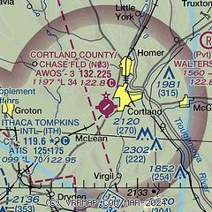
|
| Airport distance calculator |
|---|
|
|
| Sunrise and sunset |
|---|
|
Times for 14-Jun-2026
| | Local
(UTC-4) | | Zulu
(UTC) |
|---|
| Morning civil twilight | | 04:53 | | 08:53 |
| Sunrise | | 05:28 | | 09:28 |
| Sunset | | 20:43 | | 00:43 |
| Evening civil twilight | | 21:18 | | 01:18 |
|
| Current date and time |
|---|
| Zulu (UTC) | 14-Jun-2026 09:38:01 |
|---|
| Local (UTC-4) | 14-Jun-2026 05:38:01 |
|---|
|
| METAR |
|---|
| KN03 | 140915Z AUTO 00000KT 10SM CLR 13/12 A2985 RMK AO2
|
KITH
13nm SW | 140856Z AUTO 17008KT 10SM CLR 19/13 A2983 RMK AO2 SLP096 T01890128 57013
|
|
| TAF |
|---|
KITH
13nm SW | 140532Z 1406/1506 16007KT P6SM FEW140 SCT200 FM141300 20008G17KT P6SM FEW080 SCT150 FM142100 23009G18KT 5SM -SHRA BR BKN030 PROB30 1421/1501 2SM -TSRA BKN020CB FM150100 31008KT 2SM -SHRA BR OVC008 FM150500 31009KT 5SM BR BKN011
|
|
| NOTAMs |
|---|
NOTAMs are issued by the DoD/FAA and will open in a separate window not controlled by AirNav.
|
|

