FAA INFORMATION EFFECTIVE 14 MAY 2026
Location
| FAA Identifier: | 6B9 |
| Lat/Long: | 42-54-50.2550N 076-26-26.7510W
42-54.837583N 076-26.445850W
42.9139597,-76.4407642
(estimated) |
| Elevation: | 1039 ft. / 316.7 m (surveyed) |
| Variation: | 12W (2025) |
| From city: | 2 miles SW of SKANEATELES, NY |
| Time zone: | UTC -4 (UTC -5 during Standard Time) |
| Zip code: | 13152 |
Airport Operations
| Airport use: | Open to the public |
| Activation date: | 10/1948 |
| Control tower: | no |
| ARTCC: | BOSTON CENTER |
| FSS: | BUFFALO FLIGHT SERVICE STATION |
| NOTAMs facility: | BUF (NOTAM-D service available) |
| Attendance: | UNATNDD; CALL MGR |
| Pattern altitude: | 1839 ft. MSL |
| Wind indicator: | lighted |
| Segmented circle: | no |
| Lights: | ACTVT MIRL RWY 10/28 - CTAF. |
Airport Communications
| CTAF/UNICOM: | 122.8 |
| WX AWOS-3P: | 120.125 (315-685-5790) |
| SYRACUSE APPROACH: | 126.125 |
| SYRACUSE DEPARTURE: | 126.125 |
| WX AWOS-3 at 0G7 (15 nm W): | 120.0 (315-568-5362) |
| WX ASOS at SYR (19 nm NE): | PHONE 315-526-3244 |
Nearby radio navigation aids
| VOR radial/distance | | VOR name | | Freq | | Var |
|---|
| SYRr226/18.1 | | SYRACUSE VORTAC | | 117.00 | | 11W |
Airport Services
| Fuel available: | 100LL |
| Parking: | hangars and tiedowns |
| Bottled oxygen: | NONE |
| Bulk oxygen: | NONE |
Runway Information
Runway 10/28
| Dimensions: | 3134 x 58 ft. / 955 x 18 m |
| Surface: | asphalt, in good condition |
| Weight bearing capacity: | |
| Runway edge lights: | non-standard
RWY 10/28 NSTD MIRL; LGTS ARE 38 FT FM PAVEMENT EDGE. |
| RUNWAY 10 | | RUNWAY 28 |
| Latitude: | 42-54.826450N | | 42-54.777933N |
| Longitude: | 076-26.643500W | | 076-25.944683W |
| Elevation: | 1006.0 ft. | | 994.0 ft. |
| Traffic pattern: | left | | left |
| Runway heading: | 107 magnetic, 095 true | | 287 magnetic, 275 true |
| Displaced threshold: | 243 ft. | | no |
| Markings: | basic, in good condition | | basic, in good condition |
| Runway end identifier lights: | yes | | yes |
| Touchdown point: | yes, no lights | | yes, no lights |
| Obstructions: | 59 ft. trees, 440 ft. from runway, 78 ft. right of centerline, 4:1 slope to clear
RWY 10 TWO 30 FT PWR POLES 80 FT EITHER SIDE OF CNTRLN 60 FT FM THLD; 3 FT FENCE OB 20 FT FM THLD 15 FT ROAD OB 30 FT FM THLD. 4 FT FENCE OB 80 FT FM THLD. | | 51 ft. trees, 265 ft. from runway, 113 ft. right of centerline, 1:1 slope to clear
RWY 28 33 FT TREE 138 FT FM RWY 120 FT RIGHT; 10 FT FARM ROAD CROSSES APPROACH END 117 FT FM THR. |
Runway 4/22
| Dimensions: | 3350 x 130 ft. / 1021 x 40 m |
| Surface: | turf, in fair condition
HAS VARIATIONS IN RWY SFC. |
| RUNWAY 4 | | RUNWAY 22 |
| Latitude: | 42-54.620700N | | 42-55.120683N |
| Longitude: | 076-26.746150W | | 076-26.429467W |
| Elevation: | 1039.0 ft. | | 1012.0 ft. |
| Traffic pattern: | left | | left |
| Runway heading: | 037 magnetic, 025 true | | 217 magnetic, 205 true |
| Touchdown point: | yes, no lights | | yes, no lights |
| Obstructions: | 37 ft. trees, 56 ft. from runway, 80 ft. left of centerline, 1:1 slope to clear
RWY 22 FENCE CROSSES RWY 10 FT FM THR BLO RWY ELEV. | | 30 ft. fence, 69 ft. from runway, 82 ft. right of centerline, 2:1 slope to clear |
Airport Ownership and Management from official FAA records
| Ownership: | Privately-owned |
| Owner: | SKANEATELES AERODROME LLC
333 W. WASHINGTON ST STE 600
SYRACUSE, NY 13202
Phone (315) 200-1877
WEBSITE ADDRESS: WWW.SKANEATELESAERODROME.COM |
| Manager: | DANIEL ARNOLD
2984 BENSON ROAD
SKANEATELES, NY 13152
Phone 707-580-9240 |
Additional Remarks
| - | RWY 04/22 AVBL 15 MAY TO 15 OCT. |
| - | RY 28 TWO 55 FT POWER POLES 70 FT EITHER SIDE OF CNTRLN 700 FM THRESHOLD. |
| - | RY 10 3 FT FENCE 20 FT FM THLD ON BOTH SIDES 15 FT ROAD 30 FT FM THLD ON BOTH SIDES & 4 FT FENCE 80 FT FM THLD ON BOTH SIDES. -10 FT CULVERT/DITCH 50 FT LEFT OF CNTRLNE AT THRESHOLD. |
| - | FUEL AVBL 24 HRS SELF SER CREDIT CARD. |
| - | FOR CD CTC SYRACUSE APCH AT 315-455-6218. |
Instrument Procedures
NOTE: All procedures below are presented as PDF files. If you need a reader for these files, you should download the free Adobe Reader.NOT FOR NAVIGATION. Please procure official charts for flight.
FAA instrument procedures published for use from 14 May 2026 at 0901Z to 11 June 2026 at 0900Z.
IAPs - Instrument Approach Procedures |
|---|
| RNAV (GPS)-A | |
download (202KB) |
| RNAV (GPS)-B | |
download (215KB) |
| NOTE: Special Alternate Minimums apply | |
download (121KB) |
| NOTE: Special Take-Off Minimums/Departure Procedures apply | |
download (150KB) |
Other nearby airports with instrument procedures:
B16 - Whitfords Airport (11 nm NW)
0G7 - Finger Lakes Regional Airport (15 nm W)
KSYR - Syracuse Hancock International Airport (19 nm NE)
N03 - Cortland County Airport-Chase Field (22 nm SE)
KITH - Ithaca Tompkins International Airport (25 nm S)
|
|

Road maps at:
MapQuest
Bing
Google
| Aerial photo |
|---|
WARNING: Photo may not be current or correct
 Photo taken 16-Nov-2013
looking northeast.
Photo taken 16-Nov-2013
looking northeast.
Do you have a better or more recent aerial photo of Skaneateles Aero Drome that you would like to share? If so, please send us your photo.
|
| Sectional chart |
|---|
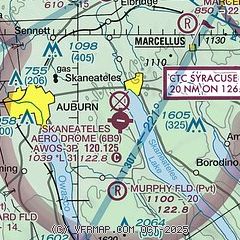
|
| Airport distance calculator |
|---|
|
|
| Sunrise and sunset |
|---|
|
Times for 31-May-2026
| | Local
(UTC-4) | | Zulu
(UTC) |
|---|
| Morning civil twilight | | 04:57 | | 08:57 |
| Sunrise | | 05:31 | | 09:31 |
| Sunset | | 20:36 | | 00:36 |
| Evening civil twilight | | 21:10 | | 01:10 |
|
| Current date and time |
|---|
| Zulu (UTC) | 31-May-2026 11:48:22 |
|---|
| Local (UTC-4) | 31-May-2026 07:48:22 |
|---|
|
| METAR |
|---|
| K6B9 | 311135Z AUTO 25009KT 10SM CLR 12/06 A3008 RMK AO2
|
KSYR
19nm NE | 311054Z 22004KT 10SM FEW180 BKN250 11/07 A3008 RMK AO2 SLP183 T01110067 PNO $
|
|
| TAF |
|---|
KSYR
19nm NE | 310525Z 3106/0106 VRB03KT P6SM SKC FM311500 29010G20KT P6SM BKN150 FM010100 VRB03KT P6SM BKN080
|
|
| NOTAMs |
|---|
NOTAMs are issued by the DoD/FAA and will open in a separate window not controlled by AirNav.
|
|

