FAA INFORMATION EFFECTIVE 11 JUNE 2026
Location
| FAA Identifier: | ITH |
| Lat/Long: | 42-29-28.9000N 076-27-31.4000W
42-29.481667N 076-27.523333W
42.4913611,-76.4587222
(estimated) |
| Elevation: | 1099 ft. / 335.0 m (surveyed) |
| Variation: | 12W (1985) |
| From city: | 3 miles NE of ITHACA, NY |
| Time zone: | UTC -4 (UTC -5 during Standard Time) |
| Zip code: | 14850 |
Airport Operations
| Airport use: | Open to the public |
| Activation date: | 10/1947 |
| Control tower: | yes |
| ARTCC: | NEW YORK CENTER |
| FSS: | BUFFALO FLIGHT SERVICE STATION |
| NOTAMs facility: | ITH (NOTAM-D service available) |
| Attendance: | CONTINUOUS
FBO AVBL 0600-1900; FBO SVCS CTC 131.6; AFT HRS CALL 607-279-0392 OR 800-876-1551. |
| Wind indicator: | lighted |
| Segmented circle: | no |
| Lights: | WHEN ATCT CLSD ACTVT MALSR RWY 32; HIRL RWY 14/32; TWY LGTS - CTAF. PAPI RWYS 14 & 32 OPR CONSLY. |
| Beacon: | white-green (lighted land airport)
Operates sunset to sunrise. |
| Landing fee: | yes, LDG FEE FOR TSNT ACFT. |
| Fire and rescue: | ARFF index C |
Airport Communications
| CTAF: | 119.6 |
| UNICOM: | 122.95 |
| ATIS: | 125.175 |
| WX AWOS-3PT: | 125.175 (607-697-7959) |
| ITHACA GROUND: | 121.8 [0530-2100] |
| ITHACA TOWER: | 119.6 [0530-2100] |
| ELMIRA APPROACH: | 124.3 |
| ELMIRA DEPARTURE: | 124.3 |
| CLEARANCE DELIVERY: | 121.8 |
| EMERG: | 121.5 |
| WX AWOS-3 at N03 (12 nm NE): | 132.225 (607-753-9784) |
- UNICOM UNMON.
- APCH/DEP SVC PRVDD BY NEW YORK ARTCC ON FREQS 133.35/372.0 (SAYRE RCAG) WHEN ELMIRA APCH CTL CLSD.
- FOR CLNC DEL WHEN ATCT CLSD CTC ELMIRA APCH ON 124.3.
Nearby radio navigation aids
| VOR radial/distance | | VOR name | | Freq | | Var |
|---|
| CFBr334/24.6 | | BINGHAMTON VOR/DME | | 112.20 | | 10W |
| NDB name | | Hdg/Dist | | Freq | | Var | | ID |
|---|
| ALPINE | | 054/20.3 | | 245 | | 12W | | ALP | .- .-.. .--. |
Airport Services
| Fuel available: | 100LL JET-A |
| Parking: | hangars and tiedowns |
| Airframe service: | MAJOR |
| Powerplant service: | MAJOR |
| Bottled oxygen: | NONE |
| Bulk oxygen: | NONE |
Runway Information
Runway 14/32
| Dimensions: | 6977 x 150 ft. / 2127 x 46 m |
| Surface: | asphalt/grooved, in good condition |
| Weight bearing capacity: | | Single wheel: | 100.0 | | Double wheel: | 192.0 | | Double tandem: | 574.0 | | Dual double tandem: | 1044.0 |
|
| Runway edge lights: | high intensity |
| RUNWAY 14 | | RUNWAY 32 |
| Latitude: | 42-29.869890N | | 42-29.093843N |
| Longitude: | 076-28.109813W | | 076-26.965895W |
| Elevation: | 1076.5 ft. | | 1099.0 ft. |
| Traffic pattern: | left | | left |
| Runway heading: | 145 magnetic, 133 true | | 325 magnetic, 313 true |
| Declared distances: | TORA:6977 TODA:6977 ASDA:6602 LDA:6602 | | TORA:6977 TODA:6977 ASDA:6602 LDA:6602 |
| Markings: | precision, in good condition | | precision, in good condition |
| Visual slope indicator: | 4-light PAPI on left (3.00 degrees glide path) | | 4-light PAPI on left (3.20 degrees glide path) |
| RVR equipment: | rollout | | touchdown |
| Approach lights: | | | MALSR: 1,400 foot medium intensity approach lighting system with runway alignment indicator lights |
| Touchdown point: | yes, no lights | | yes, no lights |
| Instrument approach: | | | ILS |
| Obstructions: | none | | 642 ft. trees, 20360 ft. from runway, 2000 ft. right of centerline, 31:1 slope to clear |
Runway 15/33
| Dimensions: | 2018 x 50 ft. / 615 x 15 m |
| Surface: | turf, in excellent condition |
| Runway edge markings: | RWY 15/33 THRS MKD WITH WHITE LIME BAR; EDGES MKD WITH REFLECTORS. |
| Operational restrictions: | RWY 15/33 CLSD NGTS, WINTER MONTHS AND AFT HVY RAIN. |
| RUNWAY 15 | | RUNWAY 33 |
| Latitude: | 42-29.595255N | | 42-29.370782N |
| Longitude: | 076-27.640588W | | 076-27.309570W |
| Elevation: | 1080.5 ft. | | 1086.4 ft. |
| Traffic pattern: | left | | left |
| Runway heading: | 144 magnetic, 132 true | | 325 magnetic, 313 true |
| Touchdown point: | yes, no lights | | yes, no lights |
| Obstructions: | 15 ft. road, 238 ft. from runway, 15:1 slope to clear | | 55 ft. ant, lighted, 1200 ft. from runway, 50 ft. right of centerline, 21:1 slope to clear |
Airport Ownership and Management from official FAA records
| Ownership: | Publicly-owned |
| Owner: | TOMPKINS COUNTY
125 EAST COURT ST
ITHACA, NY 14850
Phone 607-274-5551 |
| Manager: | ROXAN NOBLE
72 BROWN RD
ITHACA, NY 14850
Phone 607-257-0456 |
Additional Remarks
| A39-14/32 | PCR VALUE: 980/F/B/X/T |
| - | DEER & FLOCKS OF BIRDS ON & INVOF ARPT. |
| - | COLD TEMPERATURE AIRPORT. ALTITUDE CORRECTION REQUIRED AT OR BELOW -18C. |
| - | FOR CD IF UNA TO CTC ON FSS FREQ, CTC NEW YORK ARTCC. |
| - | FOR CD WHEN TWR AND ELM APCH CLSD CTC NEW YORK ARTCC. |
| - | PILOTS CONDUCTING EFVS OPS; BE AWARE LED ALS IN USE RWY 32. |
Instrument Procedures
NOTE: All procedures below are presented as PDF files. If you need a reader for these files, you should download the free Adobe Reader.NOT FOR NAVIGATION. Please procure official charts for flight.
FAA instrument procedures published for use from 11 June 2026 at 0901Z to 09 July 2026 at 0900z.
IAPs - Instrument Approach Procedures |
|---|
| ILS OR LOC RWY 32 | |
download (219KB) |
| RNAV (GPS) RWY 32 | |
download (210KB) |
| RNAV (GPS) Y RWY 14 | |
download (164KB) |
| RNAV (GPS) Z RWY 14 | |
download (172KB) |
| NOTE: Special Alternate Minimums apply | |
download (144KB) |
| NOTE: Special Take-Off Minimums/Departure Procedures apply | |
download (455KB) |
Other nearby airports with instrument procedures:
N03 - Cortland County Airport-Chase Field (12 nm NE)
6B9 - Skaneateles Aero Drome (25 nm N)
KBGM - Greater Binghamton Airport/Edwin A Link Field (27 nm SE)
0G7 - Finger Lakes Regional Airport (27 nm NW)
KELM - Elmira/Corning Regional Airport (28 nm SW)
|
|

Road maps at:
MapQuest
Bing
Google
| Aerial photo |
|---|
WARNING: Photo may not be current or correct
 Photo taken 19-May-2007
Do you have a better or more recent aerial photo of Ithaca Tompkins International Airport that you would like to share? If so, please send us your photo.
|
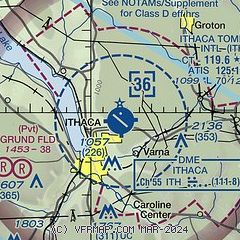
| Sectional chart |
|---|
|
CAUTION: Diagram may not be current
 Download PDF
of official airport diagram from the FAA
| Airport distance calculator |
|---|
|
|
| Sunrise and sunset |
|---|
|
Times for 25-Jun-2026
| | Local
(UTC-4) | | Zulu
(UTC) |
|---|
| Morning civil twilight | | 04:56 | | 08:56 |
| Sunrise | | 05:31 | | 09:31 |
| Sunset | | 20:46 | | 00:46 |
| Evening civil twilight | | 21:21 | | 01:21 |
|
| Current date and time |
|---|
| Zulu (UTC) | 25-Jun-2026 21:21:41 |
|---|
| Local (UTC-4) | 25-Jun-2026 17:21:41 |
|---|
|
| METAR |
|---|
KITH
2nm S | 252056Z 05008KT 8SM -RA OVC080 16/15 A3004 RMK AO2 SLP171 P0001 60010 T01610150 58015 I3000
|
KN03
12nm NE | 252055Z AUTO 08003KT 10SM -RA SCT041 BKN070 OVC080 16/15 A3006 RMK AO2
|
|
| TAF |
|---|
KITH
2nm S | 251737Z 2518/2618 VRB04KT P6SM -SHRA BKN050 TEMPO 2523/2603 VRB10G20KT 3SM -TSRA BKN050CB FM260300 15004KT P6SM SCT060 TEMPO 2607/2611 3SM BR BKN012 FM261200 26006KT P6SM BKN050
|
|
| NOTAMs |
|---|
NOTAMs are issued by the DoD/FAA and will open in a separate window not controlled by AirNav.
|
|


