FAA INFORMATION EFFECTIVE 09 JULY 2026
Location
| FAA Identifier: | WLK |
| Lat/Long: | 66-36-00.5000N 159-59-08.7000W
66-36.008333N 159-59.145000W
66.6001389,-159.9857500
(estimated) |
| Elevation: | 17.1 ft. / 5.2 m (surveyed) |
| Variation: | 16E (2010) |
| Time zone: | UTC -8 (UTC -9 during Standard Time) |
Airport Operations
| Airport use: | Open to the public |
| Activation date: | 09/1958 |
| Control tower: | no |
| ARTCC: | ANCHORAGE CENTER |
| FSS: | KOTZEBUE FLIGHT SERVICE STATION [907-442-3310] |
| Alternate FSS: | FAI FAIRBANKS FLIGHT SERVICE STATION [1-866-248-6516] |
| NOTAMs facility: | WLK (NOTAM-D service available) |
| Attendance: | UNATNDD |
| Wind indicator: | lighted |
| Segmented circle: | yes |
| Lights: | ACTVT VASI RWY 04; PAPI RWY 27; MIRL RWY 09/27 & 04/22 - CTAF. |
| Beacon: | white-green (lighted land airport)
ACTVT ROTG BCN - CTAF. |
Airport Communications
| CTAF: | 122.7 |
| WX AWOS-3P: | 135.65 (907-484-2107) |
- APCH/DEP SVC PRVDD BY ANCHORAGE ARTCC ON FREQS 119.2/263.0 (KOTZEBUE RCAG).
- COMMUNICATIONS PRVDD BY KOTZEBUE FSS ON FREQ 122.5 (SELAWIK RCO).
Nearby radio navigation aids
| VOR radial/distance | | VOR name | | Freq | | Var |
|---|
| WLK at field | | SELAWIK VOR/DME | | 114.20 | | 16E |
Airport Services
Runway Information
Runway 4/22
| Dimensions: | 3002 x 60 ft. / 915 x 18 m |
| Surface: | gravel, in good condition |
| Runway edge lights: | medium intensity |
| RUNWAY 4 | | RUNWAY 22 |
| Latitude: | 66-35.837958N | | 66-36.132238N |
| Longitude: | 159-59.532873W | | 159-58.540017W |
| Elevation: | 17.0 ft. | | 9.7 ft. |
| Traffic pattern: | left | | left |
| Runway heading: | 037 magnetic, 053 true | | 217 magnetic, 233 true |
| Visual slope indicator: | 4-box VASI on left (3.00 degrees glide path) | | |
| Touchdown point: | yes, no lights | | yes, no lights |
| Obstructions: | 5 ft. brush, 70 ft. left and right of centerline | | 6 ft. brush, 70 ft. left and right of centerline |
Runway 9/27
| Dimensions: | 2659 x 60 ft. / 810 x 18 m |
| Surface: | gravel, in good condition |
| Runway edge lights: | medium intensity |
| RUNWAY 9 | | RUNWAY 27 |
| Latitude: | 66-36.095205N | | 66-35.972795N |
| Longitude: | 159-59.795033W | | 159-58.742108W |
| Elevation: | 15.3 ft. | | 9.4 ft. |
| Traffic pattern: | left | | left |
| Runway heading: | 090 magnetic, 106 true | | 270 magnetic, 286 true |
| Visual slope indicator: | | | 4-light PAPI on right (3.00 degrees glide path) |
| Runway end identifier lights: | no | | no |
| Touchdown point: | yes, no lights | | yes, no lights |
| Obstructions: | 7 ft. brush, 65 ft. left of centerline | | 5 ft. brush, 70 ft. left and right of centerline |
Airport Ownership and Management from official FAA records
| Ownership: | Publicly-owned |
| Owner: | ALASKA DOT&PF NORTHERN REGION
NORTHERN REGION, 2301 PEGER RD
FAIRBANKS, AK 99709
Phone 907-451-2200 |
| Manager: | ALVIN WERNEKE
BOX 55
KOTZEBUE, AK 99752
Phone 907-442-3147 |
Additional Remarks
| - | RWY COND UNMNT; RCMDD VISUAL INSP PRIOR TO USE. |
| - | WX CAMERA AVBL ON INTERNET AT HTTPS://WEATHERCAMS.FAA.GOV |
Instrument Procedures
NOTE: All procedures below are presented as PDF files. If you need a reader for these files, you should download the free Adobe Reader.NOT FOR NAVIGATION. Please procure official charts for flight.
FAA instrument procedures published for use from 09 July 2026 at 0901Z to 06 August 2026 at 0900Z.
IAPs - Instrument Approach Procedures |
|---|
| RNAV (GPS) RWY 04 | |
download (260KB) |
| RNAV (GPS) RWY 27 | |
download (271KB) |
| RNAV (GPS) Y RWY 22 | |
download (279KB) |
| RNAV (GPS) Z RWY 22 | |
download (275KB) |
| VOR RWY 04 | |
download (249KB) |
| VOR RWY 22 | |
download (274KB) |
| NOTE: Special Take-Off Minimums/Departure Procedures apply | |
download |
Other nearby airports with instrument procedures:
PAIK - Bob Baker Memorial Airport (25 nm NW)
PFNO - Robert (Bob) Curtis Memorial Airport (28 nm NW)
PABL - Buckland Airport (47 nm SW)
PAFM - Ambler Airport (59 nm NE)
PAOT - Ralph Wien Memorial Airport (64 nm W)
|
|

Road maps at:
MapQuest
Bing
Google
| Aerial photo |
|---|

|
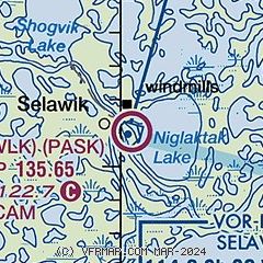
| Sectional chart |
|---|
|
| Airport distance calculator |
|---|
|
|
| Sunrise and sunset |
|---|
|
Times for 24-Jul-2026
| | Local
(UTC-8) | | Zulu
(UTC) |
|---|
| Morning civil twilight | | + | | + |
| Sunrise | | 04:45 | | 12:45 |
| Sunset | | 00:47 | | 08:47 |
| Evening civil twilight | | + | | + |
|
| Current date and time |
|---|
| Zulu (UTC) | 24-Jul-2026 13:07:21 |
|---|
| Local (UTC-8) | 24-Jul-2026 05:07:21 |
|---|
|
| METAR |
|---|
PASK
24nm W | 241256Z AUTO 06008KT 1/4SM FG OVC002 11/11 A3010 RMK AO2 SLP188 T01060106
|
PAIK
25nm NW | 241256Z AUTO 00000KT 10SM CLR 08/05 A3012 RMK AO2 SLP199 T00830050
|
PFNO
28nm NW | 241256Z AUTO 00000KT 8SM OVC031 09/07 A3010 RMK AO2 SLP194 T00890072 $
|
PABL
46nm SW | 241256Z AUTO 27013G20KT 10SM OVC008 08/07 A3016 RMK AO2 SLP216 T00780067
|
|
| NOTAMs |
|---|
NOTAMs are issued by the DoD/FAA and will open in a separate window not controlled by AirNav.
|
|

