FAA INFORMATION EFFECTIVE 15 MAY 2025
Location
| FAA Identifier: | RCE |
| Lat/Long: | 35-29-17.1000N 097-49-24.8000W
35-29.285000N 097-49.413333W
35.4880833,-97.8235556
(estimated) |
| Elevation: | 1353.8 ft. / 412.6 m (surveyed) |
| Variation: | 07E (1990) |
| From city: | 15 miles W of OKLAHOMA CITY, OK |
| Time zone: | UTC -5 (UTC -6 during Standard Time) |
| Zip code: | 73099 |
Airport Operations
| Airport use: | Open to the public |
| Control tower: | no |
| ARTCC: | FORT WORTH CENTER |
| FSS: | MC ALESTER FLIGHT SERVICE STATION |
| NOTAMs facility: | MLC (NOTAM-D service available) |
| Attendance: | MON-SAT 0730-1730 |
| Wind indicator: | lighted |
| Segmented circle: | yes |
| Lights: | DUSK-DAWN. ACTVT HIRL RY 17R/35L & MIRL 17L/35R - CTAF. |
| Beacon: | white-green (lighted land airport)
Operates sunset to sunrise. |
Airport Communications
| CTAF/UNICOM: | 123.0 |
| WX AWOS-3: | 125.05 (405-354-2617) |
| OKE CITY APPROACH: | 124.6 |
| OKE CITY DEPARTURE: | 124.6 |
| WX AWOS-3 at HSD (9 nm NE): | 120.975 (405-283-9848) |
| WX AWOS-3 at RQO (9 nm W): | 118.475 (405-262-0087) |
| WX ASOS at PWA (9 nm E): | PHONE 405-798-2013 |
| WX ASOS at OKC (12 nm SE): | PHONE 405-674-4013 |
Nearby radio navigation aids
| VOR radial/distance | | VOR name | | Freq | | Var |
|---|
| PWAr245/9.0 | | WILEY POST VOR/DME | | 113.40 | | 08E |
| IRWr300/13.0 | | WILL ROGERS VORTAC | | 114.10 | | 07E |
Airport Services
| Fuel available: | 100LL JET-A+ |
| Parking: | tiedowns |
| Airframe service: | MAJOR |
| Powerplant service: | MAJOR |
| Bottled oxygen: | HIGH |
| Bulk oxygen: | NONE |
Runway Information
Runway 17R/35L
| Dimensions: | 6014 x 100 ft. / 1833 x 30 m |
| Surface: | concrete, in good condition |
| Weight bearing capacity: | | Single wheel: | 40.0 | | Double wheel: | 60.0 |
|
| Runway edge lights: | high intensity |
| RUNWAY 17R | | RUNWAY 35L |
| Latitude: | 35-29.778348N | | 35-28.787122N |
| Longitude: | 097-49.485717W | | 097-49.490025W |
| Elevation: | 1350.5 ft. | | 1342.3 ft. |
| Traffic pattern: | right | | left |
| Runway heading: | 173 magnetic, 180 true | | 353 magnetic, 360 true |
| Markings: | nonprecision, in fair condition | | nonprecision, in fair condition |
| Visual slope indicator: | 4-light PAPI on left (3.00 degrees glide path) | | 4-light PAPI on left (3.00 degrees glide path) |
| Touchdown point: | yes, no lights | | yes, no lights |
| Obstructions: | 10 ft. other, lighted, 255 ft. from runway, 231 ft. right of centerline, 5:1 slope to clear
OIL WELL. | | 26 ft. trees, 850 ft. from runway, 330 ft. right of centerline, 25:1 slope to clear |
Runway 17L/35R
| Dimensions: | 3502 x 75 ft. / 1067 x 23 m |
| Surface: | concrete, in good condition |
| Weight bearing capacity: | |
| Runway edge lights: | medium intensity |
| RUNWAY 17L | | RUNWAY 35R |
| Latitude: | 35-29.578920N | | 35-29.001650N |
| Longitude: | 097-49.285070W | | 097-49.287630W |
| Elevation: | 1343.0 ft. | | 1339.0 ft. |
| Traffic pattern: | left | | right |
| Runway heading: | 173 magnetic, 180 true | | 353 magnetic, 360 true |
| Markings: | basic, in good condition | | basic, in good condition |
| Touchdown point: | yes, no lights | | yes, no lights |
Airport Ownership and Management from official FAA records
| Ownership: | Publicly-owned |
| Owner: | CITY OF OKLAHOMA CITY
7100 TERMINAL DR., BOX 937
OKLAHOMA CITY, OK 73159
Phone (405) 316-3200 |
| Manager: | KRISTY SLATER
5915 PHILLIP J. RHOADES RM 104
BETHANY, OK 73008
Phone 405-316-4061 |
Additional Remarks
| - | DEER ON & INVOF RY. |
| - | AEROBATIC ACFT BLO 6400 FT 1 NM RADIUS OF ARPT. |
| - | SFC CONDS RPTD MON-FRI 0800-1700. |
| - | FOR CD CTC OKE CITY APCH AT 405-681-5683. |
Instrument Procedures
NOTE: All procedures below are presented as PDF files. If you need a reader for these files, you should download the free Adobe Reader.NOT FOR NAVIGATION. Please procure official charts for flight.
FAA instrument procedures published for use from 15 May 2025 at 0901Z to 13 June 2025 at 0900z.
STARs - Standard Terminal Arrivals |
|---|
| GULLI THREE | |
2 pages:
[1] [2] (336KB) |
IAPs - Instrument Approach Procedures |
|---|
| RNAV (GPS) RWY 17R | |
download (229KB) |
| RNAV (GPS) RWY 35L | |
download (232KB) |
| VOR-B | |
download (179KB) |
| NOTE: Special Alternate Minimums apply | |
download (23KB) |
| NOTE: Special Take-Off Minimums/Departure Procedures apply | |
download (131KB) |
Other nearby airports with instrument procedures:
KHSD - Sundance Airport (9 nm NE)
KRQO - El Reno Regional Airport (9 nm W)
KPWA - Wiley Post Airport (9 nm E)
KOKC - OKC Will Rogers International Airport (12 nm SE)
KTIK - Tinker Air Force Base (22 nm E)
|
|

Road maps at:
MapQuest
Bing
Google
| Aerial photo |
|---|
WARNING: Photo may not be current or correct
 Photo taken 16-Feb-2014
looking southeast.
Photo taken 16-Feb-2014
looking southeast.
Do you have a better or more recent aerial photo of Clarence E Page Municipal Airport that you would like to share? If so, please send us your photo.
|
| Sectional chart |
|---|
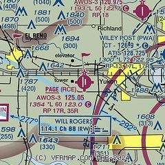
|
 Download PDF
of official airport diagram from the FAA
| Airport distance calculator |
|---|
|
|
| Sunrise and sunset |
|---|
|
Times for 24-May-2025
| | Local
(UTC-5) | | Zulu
(UTC) |
|---|
| Morning civil twilight | | 05:53 | | 10:53 |
| Sunrise | | 06:22 | | 11:22 |
| Sunset | | 20:35 | | 01:35 |
| Evening civil twilight | | 21:04 | | 02:04 |
|
| Current date and time |
|---|
| Zulu (UTC) | 25-May-2025 01:22:11 |
|---|
| Local (UTC-5) | 24-May-2025 20:22:11 |
|---|
|
| METAR |
|---|
| KRCE | 250055Z AUTO 11013KT OVC023 26/22 A2986 RMK AO2
|
KPWA
9nm E | 250053Z 11009KT 10SM FEW030 26/22 A2986 RMK AO2 SLP098 T02560222
|
KHSD
9nm NE | 250055Z AUTO 11007G13KT 10SM 26/22 A2986 RMK A01
|
KRQO
9nm W | 250055Z AUTO 12011KT 10SM BKN070 27/25 A2986 RMK AO2
|
KOKC
13nm SE | 250052Z 10012KT 10SM OVC029 25/22 A2987 RMK AO2 SLP101 T02500222 $
|
|
| TAF |
|---|
KOKC
13nm SE | 241720Z 2418/2518 14016G23KT P6SM BKN020 FM242000 16015G22KT P6SM SCT050 PROB30 2500/2505 5SM -TSRA OVC020CB FM250600 12012KT P6SM OVC250 FM251200 08010KT P6SM OVC020
|
|
| NOTAMs |
|---|
NOTAMs are issued by the DoD/FAA and will open in a separate window not controlled by AirNav.
|
|


