FAA INFORMATION EFFECTIVE 14 MAY 2026
Location
| FAA Identifier: | RKD |
| Lat/Long: | 44-03-36.5120N 069-05-58.8110W
44-03.608533N 069-05.980183W
44.0601422,-69.0996697
(estimated) |
| Elevation: | 55.4 ft. / 16.9 m (surveyed) |
| Variation: | 18W (2000) |
| From city: | 3 miles S of ROCKLAND, ME |
| Time zone: | UTC -4 (UTC -5 during Standard Time) |
| Zip code: | 04854 |
Airport Operations
| Airport use: | Open to the public |
| Activation date: | 02/1943 |
| Control tower: | no |
| ARTCC: | BOSTON CENTER |
| FSS: | BANGOR FLIGHT SERVICE STATION |
| NOTAMs facility: | RKD (NOTAM-D service available) |
| Attendance: | MON-FRI 0600-1700
ARPT MAY BE UNATNDD FM 2200-0600. |
| Wind indicator: | lighted |
| Segmented circle: | yes |
| Lights: | ACTVT MALSR RWY 13; REIL RWY 03 & 31; PAPI RWY 03, 13 & 31; HIRL RWY 13/31; MIRL RWY 03/21 - CTAF. |
| Beacon: | white-green (lighted land airport)
Operates sunset to sunrise. |
Airport Communications
| CTAF/UNICOM: | 123.05 |
| WX AWOS-3PT: | 119.025 (207-594-7946) |
| PORTLAND APPROACH: | 120.4 [0545-0000] |
| PORTLAND DEPARTURE: | 120.4 [0545-0000] |
| CLEARANCE DELIVERY: | 123.8 |
- APCH/DEP SVC PRVDD BY BOSTON ARTCC ON FREQS 128.2/263.05 (112-292) (WATERBORO RCAG); FREQS 124.25/290.50 (293-111) (BANGOR RCAG) WHEN PORTLAND APCH CTL CLSD.
Nearby radio navigation aids
| VOR radial/distance | | VOR name | | Freq | | Var |
|---|
| AUGr135/33.8 | | AUGUSTA VOR/DME | | 114.95 | | 18W |
| NDB name | | Hdg/Dist | | Freq | | Var | | ID |
|---|
| BURNHAM | | 182/39.8 | | 348 | | 18W | | BUP | -... ..- .--. |
Airport Services
| Fuel available: | 100LL JET-A |
| Parking: | hangars and tiedowns |
| Airframe service: | MAJOR |
| Powerplant service: | MAJOR |
| Bottled oxygen: | LOW |
| Bulk oxygen: | LOW |
Runway Information
Runway 13/31
| Dimensions: | 5412 x 100 ft. / 1650 x 30 m |
| Surface: | asphalt/grooved, in excellent condition |
| Weight bearing capacity: | | Single wheel: | 65.0 | | Double wheel: | 80.0 |
|
| Runway edge lights: | high intensity |
| RUNWAY 13 | | RUNWAY 31 |
| Latitude: | 44-03.714730N | | 44-03.396618N |
| Longitude: | 069-06.587653W | | 069-05.433893W |
| Elevation: | 45.6 ft. | | 54.7 ft. |
| Traffic pattern: | left | | left |
| Runway heading: | 129 magnetic, 111 true | | 309 magnetic, 291 true |
| Displaced threshold: | 400 ft. | | no |
| Declared distances: | TORA:5412 TODA:5412 ASDA:5412 LDA:5012 | | TORA:5412 TODA:5412 ASDA:5412 LDA:5412 |
| Markings: | precision, in good condition | | precision, in good condition |
| Visual slope indicator: | 4-light PAPI on right (3.00 degrees glide path) | | 4-light PAPI on left (3.00 degrees glide path) |
| Approach lights: | MALSR: 1,400 foot medium intensity approach lighting system with runway alignment indicator lights | | |
| Runway end identifier lights: | no | | yes |
| Touchdown point: | yes, no lights | | yes, no lights |
| Instrument approach: | ILS/DME | | |
| Obstructions: | none | | 40 ft. trees, 450 ft. from runway, 475 ft. right of centerline, 6:1 slope to clear |
Runway 3/21
| Dimensions: | 4000 x 100 ft. / 1219 x 30 m |
| Surface: | asphalt, in good condition |
| Weight bearing capacity: | | Single wheel: | 65.0 | | Double wheel: | 80.0 |
|
| Runway edge lights: | medium intensity |
| RUNWAY 3 | | RUNWAY 21 |
| Latitude: | 44-03.359833N | | 44-04.000167N |
| Longitude: | 069-06.044833W | | 069-05.832833W |
| Elevation: | 50.2 ft. | | 55.1 ft. |
| Traffic pattern: | left | | left |
| Runway heading: | 031 magnetic, 013 true | | 211 magnetic, 193 true |
| Declared distances: | TORA:4000 TODA:4000 ASDA:4000 LDA:4000 | | TORA:4000 TODA:4000 ASDA:4000 LDA:4000 |
| Markings: | nonprecision, in good condition | | nonprecision, in good condition |
| Visual slope indicator: | 4-light PAPI on left (3.00 degrees glide path) | | |
| Runway end identifier lights: | yes | | |
| Touchdown point: | yes, no lights | | yes, no lights |
| Obstructions: | 26 ft. trees, 357 ft. from runway, 270 ft. right of centerline, 6:1 slope to clear | | 50 ft. trees, 525 ft. from runway, 250 ft. left of centerline, 6:1 slope to clear |
Airport Ownership and Management from official FAA records
| Ownership: | Publicly-owned |
| Owner: | KNOX COUNTY
62 UNION ST
ROCKLAND, ME 04841
Phone 207-594-0420 |
| Manager: | JACOB JOHNSON
5 AIRPORT RD
OWLS HEAD, ME 04854
Phone 207-701-1715 |
Additional Remarks
| - | DEER & SEAGULLS ON & INVOF ARPT. |
| - | VOLUNTARY NGT CUFREW IN EFCT 2230-0600. |
| - | NOISE ABATEMENT PROCS IN EFCT, CALL 207-596-0617 OR VISIT WEBSITE FOR SPECIFIC INSTRUCTIONS. |
| - | FOR CD WHEN APCH CLSD CTC BOSTON ARTCC AT 603-879-6859. |
Instrument Procedures
NOTE: All procedures below are presented as PDF files. If you need a reader for these files, you should download the free Adobe Reader.NOT FOR NAVIGATION. Please procure official charts for flight.
FAA instrument procedures published for use from 14 May 2026 at 0901Z to 11 June 2026 at 0900Z.
IAPs - Instrument Approach Procedures |
|---|
| ILS OR LOC RWY 13 **CHANGED** | |
download (285KB) |
| RNAV (GPS) RWY 03 **CHANGED** | |
download (244KB) |
| RNAV (GPS) RWY 13 **CHANGED** | |
download (292KB) |
| RNAV (GPS) RWY 31 **CHANGED** | |
download (206KB) |
| NOTE: Special Alternate Minimums apply | |
download (136KB) |
| NOTE: Special Take-Off Minimums/Departure Procedures apply | |
download (514KB) |
Other nearby airports with instrument procedures:
KBST - Belfast Municipal Airport (21 nm N)
KIWI - Wiscasset Airport (27 nm W)
KAUG - Augusta State Airport (34 nm NW)
KBXM - Brunswick Executive Airport (38 nm W)
KWVL - Waterville Regional Airport (38 nm NW)
|
|

Road maps at:
MapQuest
Bing
Google
| Aerial photo |
|---|
WARNING: Photo may not be current or correct
 Photo by Pete Chaisson- Portland Flight Services
Photo taken 30-Aug-2014
looking east.
Photo by Pete Chaisson- Portland Flight Services
Photo taken 30-Aug-2014
looking east.
Do you have a better or more recent aerial photo of Knox County Regional Airport that you would like to share? If so, please send us your photo.
|
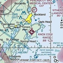
| Sectional chart |
|---|
|
| Airport distance calculator |
|---|
|
|
| Sunrise and sunset |
|---|
|
Times for 10-Jun-2026
| | Local
(UTC-4) | | Zulu
(UTC) |
|---|
| Morning civil twilight | | 04:18 | | 08:18 |
| Sunrise | | 04:54 | | 08:54 |
| Sunset | | 20:18 | | 00:18 |
| Evening civil twilight | | 20:54 | | 00:54 |
|
| Current date and time |
|---|
| Zulu (UTC) | 10-Jun-2026 21:13:39 |
|---|
| Local (UTC-4) | 10-Jun-2026 17:13:39 |
|---|
|
| METAR |
|---|
| KRKD | 102056Z AUTO 20004KT 10SM CLR 23/17 A2980 RMK AO2 SLP091 6//// T02280167 58010
|
|
| TAF |
|---|
| KRKD | 101748Z 1018/1118 17008KT P6SM SKC FM110000 22005KT 6SM BR SCT006 SCT050 OVC100 FM110400 VRB03KT 1SM BR VCSH OVC003 FM111200 VRB03KT 3SM BR OVC005
|
|
| NOTAMs |
|---|
NOTAMs are issued by the DoD/FAA and will open in a separate window not controlled by AirNav.
|
|


