FAA INFORMATION EFFECTIVE 15 MAY 2025
Location
| FAA Identifier: | RYV |
| Lat/Long: | 43-10-10.7000N 088-43-23.6000W
43-10.178333N 088-43.393333W
43.1696389,-88.7232222
(estimated) |
| Elevation: | 832.9 ft. / 253.9 m (surveyed) |
| Variation: | 01W (1990) |
| Time zone: | UTC -5 (UTC -6 during Standard Time) |
| Zip code: | 53094 |
Airport Operations
| Airport use: | Open to the public |
| Activation date: | 12/1945 |
| Control tower: | no |
| ARTCC: | CHICAGO CENTER |
| FSS: | GREEN BAY FLIGHT SERVICE STATION |
| NOTAMs facility: | RYV (NOTAM-D service available) |
| Attendance: | SAT-SUN 0700-2000, ALL MON-FRI 0600-2000
ARPT ATTENDED OTHER HRS ON REQUEST THRU FBO. |
| Wind indicator: | lighted |
| Segmented circle: | yes |
| Lights: | MIRL RWY 05/23 PRESET TO LOW SS-SR; TO INCR INTST & ACTVT REIL RWY 05 & 23; PAPI RWY 05 & 23; MIRL RWY 05/23; MIRL RWY 11/29 - CTAF. |
| Beacon: | white-green (lighted land airport)
Operates sunset to sunrise. |
Airport Communications
| CTAF/UNICOM: | 122.8 |
| WX AWOS-3: | 119.975 (920-261-0734) |
| MADISON APPROACH: | 119.15 |
| MADISON DEPARTURE: | 119.15 |
| WX AWOS-3 at UNU (15 nm N): | 120.825 (920-386-5682) |
- APCH/DEP SVC PRVDD BY CHICAGO ARTCC ON FREQS 133.3/257.925 (LONE ROCK RCAG) WHEN MADISON APCH CTL CLSD.
Nearby radio navigation aids
| VOR radial/distance | | VOR name | | Freq | | Var |
|---|
| BAEr277/19.5 | | BADGER VOR/DME | | 116.40 | | 02E |
| MSNr084/27.0 | | MADISON VORTAC | | 108.60 | | 03E |
| BJBr241/(30.2) | | WEST BEND VOR | | 109.80 | | 01W |
| NDB name | | Hdg/Dist | | Freq | | Var | | ID |
|---|
| ROCK RIVER | | at field | | 371 | | 01W | | RYV | .-. -.-- ...- |
Airport Services
| Fuel available: | 100LL JET-A+ |
| Parking: | hangars and tiedowns |
| Airframe service: | MAJOR |
| Powerplant service: | MAJOR |
| Bulk oxygen: | LOW |
Runway Information
Runway 5/23
| Dimensions: | 4429 x 75 ft. / 1350 x 23 m |
| Surface: | asphalt, in fair condition |
| Weight bearing capacity: | | Single wheel: | 30.0 | | Double wheel: | 60.0 |
|
| Runway edge lights: | medium intensity |
| RUNWAY 5 | | RUNWAY 23 |
| Latitude: | 43-09.913122N | | 43-10.349913N |
| Longitude: | 088-43.846083W | | 088-43.048677W |
| Elevation: | 817.4 ft. | | 822.9 ft. |
| Traffic pattern: | right | | left |
| Runway heading: | 054 magnetic, 053 true | | 234 magnetic, 233 true |
| Displaced threshold: | 190 ft. | | no |
| Declared distances: | TORA:4430 TODA:5110 ASDA:4550 LDA:4430 | | TORA:4430 TODA:4845 ASDA:4430 LDA:4430 |
| Markings: | nonprecision, in fair condition | | nonprecision, in fair condition |
| Visual slope indicator: | 2-light PAPI on left (3.00 degrees glide path) | | 2-light PAPI on left (3.00 degrees glide path) |
| Runway end identifier lights: | yes | | yes |
| Touchdown point: | yes, no lights | | yes, no lights |
| Obstructions: | 20 ft. brush, 280 ft. from runway, 70 ft. right of centerline, 4:1 slope to clear
APCH RATIO 23:1 TO DSPLCD THR. | | 76 ft. tree, 1450 ft. from runway, 400 ft. right of centerline, 16:1 slope to clear |
Runway 11/29
| Dimensions: | 2801 x 75 ft. / 854 x 23 m |
| Surface: | asphalt, in fair condition |
| Weight bearing capacity: | |
| Runway edge lights: | medium intensity |
| RUNWAY 11 | | RUNWAY 29 |
| Latitude: | 43-10.337347N | | 43-10.165315N |
| Longitude: | 088-43.598593W | | 088-43.014267W |
| Elevation: | 822.8 ft. | | 832.9 ft. |
| Traffic pattern: | right | | left |
| Runway heading: | 113 magnetic, 112 true | | 293 magnetic, 292 true |
| Markings: | nonprecision, in fair condition | | nonprecision, in fair condition |
| Touchdown point: | yes, no lights | | yes, no lights |
| Obstructions: | 42 ft. trees, 900 ft. from runway, 225 ft. left of centerline, 16:1 slope to clear | | 64 ft. tree, 1100 ft. from runway, 350 ft. right of centerline, 14:1 slope to clear |
Airport Ownership and Management from official FAA records
| Ownership: | Publicly-owned |
| Owner: | CITY OF WATERTOWN
106 JONES
WATERTOWN, WI 53094
Phone 920-262-4000 |
| Manager: | JEFF BAUM
1741 RIVER DRIVE
WATERTOWN, WI 53094
Phone 920-261-4567 |
Additional Remarks
| - | DEER ON & INVOF ARPT. |
| - | DUCKS & SEAGULLS OCCASSIONALLY NEAR ARPT DURING SEASONAL MIGRATIONS. |
| - | FOR CD CTC MADISON APP/DEP CON AT 608-249-8240. WHEN MADISON APCH CLSD, FOR CD CTC CHICAGO ARTCC AT 630-906-8921. |
Instrument Procedures
NOTE: All procedures below are presented as PDF files. If you need a reader for these files, you should download the free Adobe Reader.NOT FOR NAVIGATION. Please procure official charts for flight.
FAA instrument procedures published for use from 15 May 2025 at 0901Z to 13 June 2025 at 0900z.
IAPs - Instrument Approach Procedures |
|---|
| RNAV (GPS) RWY 05 | |
download (225KB) |
| RNAV (GPS) RWY 11 | |
download (232KB) |
| RNAV (GPS) RWY 23 | |
download (221KB) |
| RNAV (GPS) RWY 29 | |
download (218KB) |
| NDB RWY 05 | |
download (178KB) |
| NDB RWY 23 | |
download (199KB) |
| NOTE: Special Alternate Minimums apply | |
download (140KB) |
| NOTE: Special Take-Off Minimums/Departure Procedures apply | |
download (430KB) |
Other nearby airports with instrument procedures:
61C - Fort Atkinson Municipal Airport (13 nm S)
KUNU - Dodge County Airport (15 nm N)
KHXF - Hartford Municipal Airport (18 nm NE)
87Y - Blackhawk Airfield (21 nm W)
KUES - Waukesha County Airport (23 nm E)
|
|

Road maps at:
MapQuest
Bing
Google
| Aerial photo |
|---|
WARNING: Photo may not be current or correct
 Photo taken 25-Sep-2006
Do you have a better or more recent aerial photo of Watertown Municipal Airport that you would like to share? If so, please send us your photo.
|
| Sectional chart |
|---|
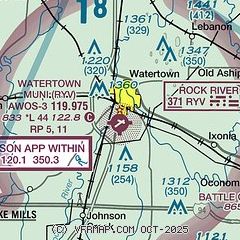
|
| Airport distance calculator |
|---|
|
|
| Sunrise and sunset |
|---|
|
Times for 25-May-2025
| | Local
(UTC-5) | | Zulu
(UTC) |
|---|
| Morning civil twilight | | 04:49 | | 09:49 |
| Sunrise | | 05:23 | | 10:23 |
| Sunset | | 20:20 | | 01:20 |
| Evening civil twilight | | 20:54 | | 01:54 |
|
| Current date and time |
|---|
| Zulu (UTC) | 26-May-2025 02:22:44 |
|---|
| Local (UTC-5) | 25-May-2025 21:22:44 |
|---|
|
| METAR |
|---|
| KRYV | 260155Z AUTO 11004KT 10SM CLR 11/05 A3030 RMK AO2 T01140050
|
KUNU
15nm N | 260155Z AUTO 11005KT 10SM CLR 12/06 A3031 RMK AO2 T01170056 TSNO
|
|
| TAF |
|---|
KUES
27nm E | 251720Z 2518/2618 32005KT P6SM BKN045 FM252300 09007KT P6SM FEW060 FM260700 VRB03KT P6SM FEW250 FM261500 06007KT P6SM FEW050
|
KMSN
28nm W | 251720Z 2518/2618 33004KT P6SM SCT050 SCT250 FM252300 07005KT P6SM SCT050 FM261600 08007KT P6SM FEW050
|
|
| NOTAMs |
|---|
NOTAMs are issued by the DoD/FAA and will open in a separate window not controlled by AirNav.
|
|


