FAA INFORMATION EFFECTIVE 22 JANUARY 2026
Location
| FAA Identifier: | RYW |
| Lat/Long: | 30-29-54.9000N 097-58-10.1000W
30-29.915000N 097-58.168333W
30.4985833,-97.9694722
(estimated) |
| Elevation: | 1230.4 ft. / 375.0 m (surveyed) |
| Variation: | 04E (2020) |
| From city: | 2 miles NE of LAGO VISTA, TX |
| Time zone: | UTC -6 (UTC -5 during Daylight Saving Time) |
| Zip code: | 78645 |
Airport Operations
| Airport use: | Open to the public |
| Activation date: | 09/1973 |
| Control tower: | no |
| ARTCC: | HOUSTON CENTER |
| FSS: | SAN ANGELO FLIGHT SERVICE STATION |
| NOTAMs facility: | RYW (NOTAM-D service available) |
| Attendance: | M-F 0800-1800 |
| Wind indicator: | lighted |
| Segmented circle: | no |
| Lights: | DUSK-DAWN. MIRL RWY 15/33 PRESET LOW INTST; TO INCR INTST ACTVT - CTAF. PAPI RWYS 15 & 33 OPR CONSLY. |
| Beacon: | white-green (lighted land airport)
Operates sunset to sunrise. |
Airport Communications
| CTAF/UNICOM: | 122.725 |
| WX AWOS-3PT: | 119.375 (512-267-1365) |
| AUSTIN APPROACH: | 119.0 [1345-0600Z++ MON-THU; 1345-2345Z++ FRI; CLSD SAT, SUN AND HOL EXC BY NOTAM, HRS SUBJ TO CHG.] |
| AUSTIN DEPARTURE: | 119.0 [1345-0600Z++ MON-THU; 1345-2345Z++ FRI; CLSD SAT, SUN AND HOL EXC BY NOTAM, HRS SUBJ TO CHG.] |
| AEROZ DP: | 119.0 |
| BNDIA DP: | 119.0 |
| ELOEL DP: | 119.0 |
| GABOO STAR: | 127.225 |
| ILEXY DP: | 119.0 |
| MUCKY DP: | 119.0 |
| POTRR STAR: | 127.225 |
| SAYBR DP: | 119.0 |
| SZAGI STAR: | 118.15 ;SFC-7000 FT 119.0 ;8,000-12,000 FT |
| WX AWOS-3PT at GTU (18 nm NE): | PHONE 512-869-3430 |
Nearby radio navigation aids
| VOR radial/distance | | VOR name | | Freq | | Var |
|---|
| CWKr282/23.9 | | CENTEX VORTAC | | 112.80 | | 06E |
| GRKr187/33.0 | | GRAY VOR/DME | | 111.80 | | 07E |
Airport Services
| Fuel available: | 100LL |
| Parking: | tiedowns |
Runway Information
Runway 15/33
| Dimensions: | 3808 x 50 ft. / 1161 x 15 m |
| Surface: | asphalt, in fair condition |
| Weight bearing capacity: | | Single wheel: | 12.5, GWT PER AMGR. |
|
| Runway edge lights: | medium intensity |
| RUNWAY 15 | | RUNWAY 33 |
| Latitude: | 30-30.212715N | | 30-29.617755N |
| Longitude: | 097-58.283938W | | 097-58.051307W |
| Elevation: | 1230.4 ft. | | 1209.3 ft. |
| Traffic pattern: | left | | left |
| Runway heading: | 157 magnetic, 161 true | | 337 magnetic, 341 true |
| Declared distances: | TORA:3808 TODA:3808 ASDA:3808 LDA:3808 | | TORA:3808 TODA:3808 ASDA:3808 LDA:3808 |
| Markings: | nonprecision, in fair condition | | nonprecision, in fair condition |
| Visual slope indicator: | 2-light PAPI on left (4.00 degrees glide path) | | 2-light PAPI on left (3.50 degrees glide path) |
| Touchdown point: | yes, no lights | | yes, no lights |
| Obstructions: | 25 ft. trees, 200 ft. from runway, 90 ft. left of centerline
30 FT HGR, 0 FT DSTC, 220 R. | | 10 ft. pline, marked, 200 ft. from runway, 234 ft. left of centerline
14-20 FT HNGRS R/L. |
Airport Ownership and Management from official FAA records
| Ownership: | Publicly-owned |
| Owner: | CITY OF LAGO VISTA
5803 THUNDERBIRD DR
LAGO VISTA, TX 78645
Phone 512-267-1155 |
| Manager: | JONATHAN HANDFORD
CITY OF LAGO VISTA, 5803 THUNDERBIRD
LAGO VISTA, TX 78645
Phone 737-202-4378
DIR, PARKS & REC/AMGR. ADD'L CTC: CHRIS WILLIAMS, 737-704-4304. |
Additional Remarks
| - | DEER ON& INVOF ARPT. |
| - | UNICOM NOT MNT. |
| - | FOR CD CTC AUSTIN APCH AT 512-369-7865. |
| - | CALM WIND RWY I5. |
Instrument Procedures
NOTE: All procedures below are presented as PDF files. If you need a reader for these files, you should download the free Adobe Reader.NOT FOR NAVIGATION. Please procure official charts for flight.
FAA instrument procedures published for use from 22 January 2026 at 0901Z to 19 February 2026 at 0900z.
STARs - Standard Terminal Arrivals |
|---|
| BLEWE FIVE | |
download (158KB) |
| GABOO ONE (RNAV) | |
download (128KB) |
| POTRR TWO (RNAV) | |
download (166KB) |
| SZAGI THREE (RNAV) | |
download (196KB) |
IAPs - Instrument Approach Procedures |
|---|
| RNAV (GPS) RWY 15 | |
download (253KB) |
| NOTE: Special Alternate Minimums apply | |
download (139KB) |
Departure Procedures |
|---|
| AEROZ TWO (RNAV) | |
download (152KB) |
| BNDIA THREE (RNAV) | |
download (141KB) |
| ELOEL THREE (RNAV) | |
download (165KB) |
| ILEXY FOUR (RNAV) | |
download (181KB) |
| MUCKY THREE (RNAV) | |
download (138KB) |
| SAYBR THREE (RNAV) | |
download (148KB) |
| NOTE: Special Take-Off Minimums/Departure Procedures apply | |
download (292KB) |
Other nearby airports with instrument procedures:
3R9 - Lakeway Airpark (9 nm S)
KGTU - Georgetown Executive Airport (18 nm NE)
KBMQ - Burnet Municipal Airport/Kate Craddock Field (20 nm NW)
KEDC - Austin Executive Airport (22 nm E)
KAUS - Austin-Bergstrom International Airport (24 nm SE)
|
|

Road maps at:
MapQuest
Bing
Google
| Aerial photo |
|---|
WARNING: Photo may not be current or correct
 Photo by Mike Mee
Taken in March 2016
looking southeast.
Photo by Mike Mee
Taken in March 2016
looking southeast.
Do you have a better or more recent aerial photo of Lago Vista TX/Rusty Allen Airport that you would like to share? If so, please send us your photo.
|
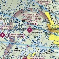
| Sectional chart |
|---|
|
| Airport distance calculator |
|---|
|
|
| Sunrise and sunset |
|---|
|
Times for 09-Feb-2026
| | Local
(UTC-6) | | Zulu
(UTC) |
|---|
| Morning civil twilight | | 06:54 | | 12:54 |
| Sunrise | | 07:18 | | 13:18 |
| Sunset | | 18:14 | | 00:14 |
| Evening civil twilight | | 18:39 | | 00:39 |
|
| Current date and time |
|---|
| Zulu (UTC) | 10-Feb-2026 05:22:43 |
|---|
| Local (UTC-6) | 09-Feb-2026 23:22:43 |
|---|
|
| METAR |
|---|
| KRYW | 100455Z AUTO 17006G14KT 10SM CLR 18/12 A3010 RMK AO2 T01810120
|
KATT
18nm SE | 100451Z AUTO 16006KT 10SM CLR 19/13 A3007 RMK AO2 SLP176 T01890133
|
KGTU
19nm NE | 100455Z AUTO 17009G19KT 10SM CLR 19/13 A3007 RMK AO2 SLP177 T01940128 PNO
|
KAUS
19nm SE | 100453Z 18013KT 10SM FEW200 18/14 A3007 RMK AO2 SLP175 T01830139 $
|
KBMQ
20nm NW | 100453Z AUTO 17007KT 10SM CLR 19/11 A3006 RMK AO2 SLP166 T01940111
|
|
| TAF |
|---|
KAUS
19nm SE | 100252Z 1003/1106 16008KT P6SM FEW250 FM100900 19005KT P6SM OVC015 FM101300 19003KT 6SM BR OVC009 FM101600 19011KT P6SM OVC035 FM101800 19013KT P6SM OVC035 FM110000 16007KT P6SM OVC250
|
|
| NOTAMs |
|---|
NOTAMs are issued by the DoD/FAA and will open in a separate window not controlled by AirNav.
|
|

