FAA INFORMATION EFFECTIVE 09 JULY 2026
Location
| FAA Identifier: | S03 |
| Lat/Long: | 42-11-25.0000N 122-39-38.3000W
42-11.416667N 122-39.638333W
42.1902778,-122.6606389
(estimated) |
| Elevation: | 1888.5 ft. / 575.6 m (surveyed) |
| Variation: | 18E (1985) |
| From city: | 2 miles E of ASHLAND, OR |
| Time zone: | UTC -7 (UTC -8 during Standard Time) |
| Zip code: | 97520 |
Airport Operations
| Airport use: | Open to the public |
| Activation date: | 04/1947 |
| Control tower: | no |
| ARTCC: | SEATTLE CENTER |
| FSS: | MC MINNVILLE FLIGHT SERVICE STATION |
| NOTAMs facility: | MMV (NOTAM-D service available) |
| Attendance: | OCT-APR MON-SAT 0800-1700, MAY-SEP MON-SAT 0800-1800, ALL SUN 0900-1700 |
| Pattern altitude: | 2903.5 ft. MSL |
| Wind indicator: | lighted |
| Segmented circle: | yes |
| Lights: | ACTVT MIRL RY 12/30, & REIL RY 30 - CTAF. PAPI RYS 12 & 30 OPR 24 HRS. |
| Beacon: | white-green (lighted land airport)
Operates sunset to sunrise. |
Airport Communications
| CTAF/UNICOM: | 122.8 |
| CASCADE APPROACH: | 124.3 ;0600-2300 |
| CASCADE DEPARTURE: | 124.3 ;0600-2300 |
| WX ASOS at MFR (15 nm NW): | 127.25 (541-204-0136) |
- AUTOMATED UNICOM.
- APCH/DEP SVC PRVDD BY SEATTLE ARTCC (ZSE) ON FREQS 127.55/254.35 (KING MOUNTAIN RCAG) WHEN CASCADE APCH CLSD.
Nearby radio navigation aids
| VOR radial/distance | | VOR name | | Freq | | Var |
|---|
| OEDr128/20.7 | | ROGUE VALLEY VORTAC | | 113.60 | | 19E |
| NDB name | | Hdg/Dist | | Freq | | Var | | ID |
|---|
| MONTAGUE | | 329/28.9 | | 404 | | 15E | | MOG | -- --- --. |
Airport Services
| Fuel available: | 100LL JET-A |
| Parking: | tiedowns |
| Airframe service: | MAJOR |
| Powerplant service: | MAJOR |
| Bottled oxygen: | LOW |
| Bulk oxygen: | NONE |
Runway Information
Runway 12/30
| Dimensions: | 3603 x 75 ft. / 1098 x 23 m |
| Surface: | asphalt, in excellent condition |
| Weight bearing capacity: | |
| Runway edge lights: | medium intensity |
| RUNWAY 12 | | RUNWAY 30 |
| Latitude: | 42-11.648567N | | 42-11.185730N |
| Longitude: | 122-39.887332W | | 122-39.388423W |
| Elevation: | 1849.4 ft. | | 1888.5 ft. |
| Traffic pattern: | left | | left |
| Runway heading: | 123 magnetic, 141 true | | 303 magnetic, 321 true |
| Displaced threshold: | no | | 190 ft. |
| Markings: | basic, in good condition | | basic, in good condition |
| Visual slope indicator: | 2-light PAPI on left (3.75 degrees glide path) | | 2-light PAPI on right (4.00 degrees glide path) |
| Runway end identifier lights: | | | yes |
| Touchdown point: | yes, no lights | | yes, no lights |
| Obstructions: | 12 ft. road, 240 ft. from runway, 3:1 slope to clear
+40 FT TREE 110 FT FM RY END 100 FT R.; 9' BRIARS AT 0-200' FROM RUNWAY END AND 60-125' RIGHT OF CENTER LINE. | | 55 ft. trees, 355 ft. from runway, 80 ft. left of centerline, 2:1 slope to clear
9' BRIARS AT 0-200' FROM RUNWAY END AND 80-125' LEFT OF CENTERLINE. |
Airport Ownership and Management from official FAA records
| Ownership: | Publicly-owned |
| Owner: | CITY OF ASHLAND
CITY HALL 2- E. MAIN ST
ASHLAND, OR 97520
Phone 541-488-5587 |
| Manager: | ROBERT SKINNER
403 DEAD INDIAN MEMORIAL ROAD
ASHLAND, OR 97520
Phone 541-482-7675 |
Additional Remarks
| - | RY 12 HAS 165 FT TERRAIN 5000 FT AT 29:1. |
| - | DEER & BIRDS ON & INVOF ARPT |
| - | 24 HR CREDIT CARD FUEL AVBL. |
| - | TAXILANE WIDTH IN VCNTY HANGARS: 36 FEET FROM CENTER. |
| - | FOR CD CTC CASCADE APCH AT 541-607-4674/4675, WHEN APCH CLSD CTC SEATTLE ARTCC AT 253-351-3694. |
Instrument Procedures
There are no published instrument procedures at S03.
Some nearby airports with instrument procedures:
KMFR - Rogue Valley International/Medford Airport (15 nm NW)
KSIY - Siskiyou County Airport (26 nm S)
3S8 - Grants Pass Airport (38 nm NW)
KLMT - Crater Lake/Klamath Regional Airport (41 nm E)
O46 - Weed Airport (44 nm S)
|
|

Road maps at:
MapQuest
Bing
Google
| Aerial photo |
|---|
WARNING: Photo may not be current or correct

Do you have a better or more recent aerial photo of Ashland Municipal Airport-Sumner Parker Field that you would like to share? If so, please send us your photo.
|
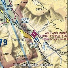
| Sectional chart |
|---|
|
CAUTION: Diagram may not be current

| Airport distance calculator |
|---|
|
|
| Sunrise and sunset |
|---|
|
Times for 29-Jul-2026
| | Local
(UTC-7) | | Zulu
(UTC) |
|---|
| Morning civil twilight | | 05:30 | | 12:30 |
| Sunrise | | 06:02 | | 13:02 |
| Sunset | | 20:32 | | 03:32 |
| Evening civil twilight | | 21:04 | | 04:04 |
|
| Current date and time |
|---|
| Zulu (UTC) | 30-Jul-2026 00:59:48 |
|---|
| Local (UTC-7) | 29-Jul-2026 17:59:48 |
|---|
|
| METAR |
|---|
KMFR
15nm NW | 300053Z 35011G18KT 10SM CLR 32/11 A2985 RMK AO2 SLP095 T03170106
|
|
| TAF |
|---|
KMFR
15nm NW | 292121Z 2921/3018 31012G21KT P6SM SKC FM300400 VRB03KT P6SM SKC
|
|
| NOTAMs |
|---|
NOTAMs are issued by the DoD/FAA and will open in a separate window not controlled by AirNav.
|
|


