FAA INFORMATION EFFECTIVE 25 DECEMBER 2025
Location
| FAA Identifier: | S25 |
| Lat/Long: | 47-47-34.7970N 103-14-57.6680W
47-47.579950N 103-14.961133W
47.7929992,-103.2493522
(estimated) |
| Elevation: | 2135.1 ft. / 650.8 m (surveyed) |
| Variation: | 07E (2025) |
| From city: | 1 mile ESE of WATFORD CITY, ND |
| Time zone: | UTC -6 (UTC -5 during Daylight Saving Time) |
| Zip code: | 58854 |
Airport Operations
| Airport use: | Open to the public |
| Control tower: | no |
| ARTCC: | SALT LAKE CITY CENTER |
| FSS: | GRAND FORKS FLIGHT SERVICE STATION |
| NOTAMs facility: | GFK (NOTAM-D service available) |
| Attendance: | MON-FRI 0800-1700
ON CALL WEEKENDS AND NIGHTS |
| Wind indicator: | lighted |
| Segmented circle: | yes |
| Lights: | ACTVT PAPI RWY 12 & 30 - CTAF. MIRL RWY 12/30 PRESET ON LOW INTST DUSK-DAWN, TO INCR INTST - CTAF. |
| Beacon: | white-green (lighted land airport)
Operates sunset to sunrise. |
Airport Communications
| CTAF/UNICOM: | 122.8 |
| WX AWOS-3PT: | 118.125 (701-842-4855) |
- UNICOM LCTD AT SHERIFF'S OFFICE.
- APCH/DEP CTL SVC PRVDD BY SALT LAKE CITY ARTCC ( ZLC) ON FREQS 126.85/305.2 (GLASGOW RCAG).
Nearby radio navigation aids
| VOR radial/distance | | VOR name | | Freq | | Var |
|---|
| ISNr136/34.2 | | WILLISTON VOR/DME | | 116.30 | | 08E |
Airport Services
| Fuel available: | 100LL JET-A
A:FULL SVC FUEL AVBL 800-1700 M-F AND SELF SVC WITH CREDIT CARD ALL OTHER HOURS. |
| Parking: | hangars and tiedowns |
| Airframe service: | MINOR |
| Powerplant service: | MINOR |
| Bottled oxygen: | NONE |
| Bulk oxygen: | NONE |
Runway Information
Runway 12/30
| Dimensions: | 6550 x 75 ft. / 1996 x 23 m |
| Surface: | concrete/grooved, in excellent condition |
| Weight bearing capacity: | | PCN 28 /R/B/W/T | | Single wheel: | 78.0 | | Double wheel: | 98.0 | | Double tandem: | 186.0 |
|
| Runway edge lights: | medium intensity |
| RUNWAY 12 | | RUNWAY 30 |
| Latitude: | 47-47.871178N | | 47-47.288660N |
| Longitude: | 103-15.633695W | | 103-14.288683W |
| Elevation: | 2063.1 ft. | | 2135.0 ft. |
| Traffic pattern: | left | | left |
| Runway heading: | 116 magnetic, 123 true | | 296 magnetic, 303 true |
| Displaced threshold: | 1023 ft. | | 750 ft. |
| Declared distances: | TORA:5800 TODA:5800 ASDA:6550 LDA:5500 | | TORA:5500 TODA:5500 ASDA:6400 LDA:5650 |
| Markings: | nonprecision, in good condition | | nonprecision, in good condition |
| Visual slope indicator: | 2-light PAPI on left (3.00 degrees glide path) | | 2-light PAPI on left (3.00 degrees glide path) |
| Touchdown point: | yes, no lights | | yes, no lights |
| Obstructions: | 16 ft. road, 240 ft. from runway, 250 ft. right of centerline, 3:1 slope to clear
ALSO +306 FT TWR 6600 FT FROM THR 4000 FT RIGHT OF CNTRLN EXTDD. | | 16 ft. road, lighted, 550 ft. from runway, 300 ft. left of centerline, 21:1 slope to clear
+167'HILL LGTD W/OBS LGTS. |
Airport Ownership and Management from official FAA records
| Ownership: | Publicly-owned |
| Owner: | WATFORD CITY ARPT AUTH
BOX 730
WATFORD CITY, ND 58854
Phone (701) 570-2646 |
| Manager: | LUKE TAYLOR
BOX 730
WATFORD CITY, ND 58854
Phone (701) 570-2646
ADDNL CONTACT - FBO PHONE 701-300-3045. |
Additional Remarks
| - | AFT WINTER STORMS CFM ARPT CONDS WITH AMGR; CALL (701) 300-3045 OR 701-570-2646. |
| - | DEER & ANTELOPE ON OR INVOF ARPT. |
| - | FOR CD CTC SALT LAKE ARTCC AT 801-320-2568. |
Instrument Procedures
NOTE: All procedures below are presented as PDF files. If you need a reader for these files, you should download the free Adobe Reader.NOT FOR NAVIGATION. Please procure official charts for flight.
FAA instrument procedures published for use from 25 December 2025 at 0901z to 22 January 2026 at 0900z.
IAPs - Instrument Approach Procedures |
|---|
| RNAV (GPS) RWY 12 | |
download (237KB) |
| RNAV (GPS) RWY 30 | |
download (254KB) |
| NOTE: Special Alternate Minimums apply | |
download (175KB) |
| NOTE: Special Take-Off Minimums/Departure Procedures apply | |
download (405KB) |
Other nearby airports with instrument procedures:
9Y1 - Dunn County Airport - Weydahl Field (31 nm SE)
05D - New Town Municipal Airport (33 nm E)
KXWA - Williston Basin International Airport (34 nm NW)
D60 - Tioga Municipal Airport (38 nm N)
KSDY - Sidney-Richland Regional Airport (38 nm W)
|
|

Road maps at:
MapQuest
Bing
Google
| Aerial photo |
|---|
WARNING: Photo may not be current or correct
 Photo taken 12-Mar-2014
looking southwest from 2500 AGL.
Photo taken 12-Mar-2014
looking southwest from 2500 AGL.
Do you have a better or more recent aerial photo of Watford City Municipal Airport that you would like to share? If so, please send us your photo.
|
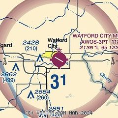
| Sectional chart |
|---|
|
CAUTION: Diagram may not be current

| Airport distance calculator |
|---|
|
|
| Sunrise and sunset |
|---|
|
Times for 12-Jan-2026
| | Local
(UTC-6) | | Zulu
(UTC) |
|---|
| Morning civil twilight | | 08:05 | | 14:05 |
| Sunrise | | 08:40 | | 14:40 |
| Sunset | | 17:23 | | 23:23 |
| Evening civil twilight | | 17:58 | | 23:58 |
|
| Current date and time |
|---|
| Zulu (UTC) | 12-Jan-2026 11:23:03 |
|---|
| Local (UTC-6) | 12-Jan-2026 05:23:03 |
|---|
|
| METAR |
|---|
| KS25 | 121055Z AUTO 24010KT 10SM CLR 01/M03 A3001 RMK AO2
|
|
| NOTAMs |
|---|
NOTAMs are issued by the DoD/FAA and will open in a separate window not controlled by AirNav.
|
|


