FAA INFORMATION EFFECTIVE 16 APRIL 2026
Location
| FAA Identifier: | SAT |
| Lat/Long: | 29-32-02.2500N 098-28-08.6050W
29-32.037500N 098-28.143417W
29.5339583,-98.4690569
(estimated) |
| Elevation: | 809.1 ft. / 246.6 m (surveyed) |
| Variation: | 04E (2020) |
| From city: | 7 miles N of SAN ANTONIO, TX |
| Time zone: | UTC -5 (UTC -6 during Standard Time) |
| Zip code: | 78216 |
Airport Operations
| Airport use: | Open to the public |
| Activation date: | 07/1942 |
| Control tower: | yes |
| ARTCC: | HOUSTON CENTER |
| FSS: | SAN ANGELO FLIGHT SERVICE STATION |
| NOTAMs facility: | SAT (NOTAM-D service available) |
| Attendance: | CONTINUOUS |
| Wind indicator: | lighted |
| Segmented circle: | no |
| Lights: | SS-SR |
| Beacon: | white-green (lighted land airport)
Operates sunset to sunrise. |
| Landing fee: | yes |
| Fire and rescue: | ARFF index C |
| Airline operations: | SAT IS ARFF INDEX C; ARFF INDEX D AVBL WITH PPR. |
| International operations: | customs landing rights airport |
Airport Communications
| UNICOM: | 122.95 |
| WX ASOS: | PHONE 210-939-4003 |
| SAN ANTONIO GROUND: | 121.9 348.6 |
| SAN ANTONIO TOWER: | 119.8 257.8 |
| SAN ANTONIO APPROACH: | 118.05 ;141-270 SAT 121.375 124.45 ;360-090 SAT 125.1 ;271-359 SAT 128.05 ;091-140 SAT 257.625 ;115-154 SAT/035-056 SAT 307.0 ;271-359 SAT 318.1 ;091-149 SAT 335.625 ;360-090 SAT 353.5 ;141-270 SAT 125.7 127.1 251.125 290.225 |
| SAN ANTONIO DEPARTURE: | 118.05 ;141-270 SAT 124.45 ;360-090 SAT 125.1 ;271-359 SAT 128.05 ;091-140 SAT 307.0 ;271-359 SAT 318.1 ;091-149 SAT 335.625 ;360-090 SAT 353.5 ;141-270 SAT 125.7 127.1 251.125 290.225 |
| CLEARANCE DELIVERY: | 126.7 |
| ALAMO DP: | 125.1 ;RWY 04, 22, 31 127.1 ;RWY 13 269.1 ;RWY 13 307.0 ;RWY 04, 22, 31 |
| ALISS DP: | 125.1 ;RY 31L/R 125.7 ;RY 13L/R, 22 127.1 ;RWY 4 269.1 ;RY 4 290.225 ;RY 13L/R, 22 307.0 ;RY 31L/R |
| BOWIE DP: | 125.1 ;RWY 04 LRD TRANSITION 125.7 ;RWY 13, 22, 31 127.1 ;RWY 04 CRP TRANSITION 269.1 ;RWY 04 CRP TRANSITION 290.225 ;RWY 04, 13, 31 307.0 ;RWY 04 LRD TRANSITION |
| CENTERPOINT STAR: | 125.1 ;RWY 13R, 22 125.7 ;RWY 04, 31L 290.225 ;RWY 04, 31L 307.0 ;RWY 13R, 22 |
| CLASS C: | 118.05 ;141-270 SAT 124.45 ;360-090 SAT 125.1 ;271-359 SAT 128.05 ;091-140 SAT 307.0 ;271-359 SAT 318.1 ;091-140 SAT 335.625 ;360-090 SAT 353.5 ;141-270 SAT |
| CRVZA RNAV STAR: | 125.7 290.225 |
| D-ATIS: | 118.9 |
| DNKIN RNAV STAR: | 125.1 307.0 |
| EMERG: | 121.5 243.0 |
| IC: | 125.1 ;271-359 SAT 307.0 ;271-359 SAT |
| LEJON DP: | 125.1 ;RWY 04, 22, 31 125.7 ;RWY 13 290.225 ;RWY 13 307.0 ;RWY 04, 22, 31 |
| LEMIG STAR: | 125.7 290.225 |
| MARCS STAR: | 127.1 269.1 |
| POPPO RNAV STAR: | 125.1 307.0 |
| QERVO RNAV STAR: | 127.1 269.1 |
| SLENA DP: | 125.7 ;RY 13R/L 31L/R, 22 127.1 ;RY 4 269.1 ;RY 4 290.225 ;RY 13R/L, 31L/R, 22 |
| SNIDR DP: | 125.7 ;RY 22 127.1 ;RY 13R/L, 31L/R, 4 269.1 ;RY 13R/L, 31L/R, 4 290.225 ;RY 22 |
| STONEWALL STAR: | 125.1 307.0 |
| TJANO DP: | 125.7 ;RY 13R/L, 31L/R, 22 127.1 ;RY 4 269.1 ;RY 4 290.225 ;RY 13R/L,31L/R, 22 |
| YODUH DP: | 125.1 ;RY 31L/R 125.7 ;RY 22 127.1 ;RY 13R/L, 4 269.1 ;RY 13R/L, 4 290.225 ;RY 22 307.0 ;RY 31L/R |
| WX ASOS at SSF (12 nm S): | PHONE 210-927-9391 |
| WX AWOS-3 at 5C1 (16 nm NW): | 118.725 (830-755-9099) |
- 128.05 397.0 348.4 289.2 TRACON PIT/UPT CAT VI TRAINING AREA(DO NOT ADVERTISE.
- CTN: DUE CONST UFN; ATCT UNABLE TO OBSERVE TFC ON SE PORTION OF ARPT. TWR INSTRUCTIONS ON TWYS & RAMPS IN THIS AREA WILL BE ADZY ONLY. SMALL ACFT DEPARTING RWY 3 ANTICIPATE TKOF FM INT TWY G.
- SAID IN USE. OPERATE TRANSPONDERS WITH ALTITUDE REPORTING MODE AND ADS-B (IF EQUIPPED) ENABLED ON ALL AIRPORT SURFACES.
- SAT REQUEST BAZ ATIS, 119.325, ADDED TO THIS STAR.
Nearby radio navigation aids
| VOR radial/distance | | VOR name | | Freq | | Var |
|---|
| SATr175/6.6 | | SAN ANTONIO VORTAC | | 116.80 | | 08E |
| RNDr270/9.6 | | RANDOLPH VORTAC | | 112.30 | | 05E |
| SSFr352/(16.6) | | STINSON VOR | | 108.40 | | 03E |
| NDB name | | Hdg/Dist | | Freq | | Var | | ID |
|---|
| DEVINE | | 039/34.2 | | 359 | | 07E | | HHH | .... .... .... |
Airport Services
| Fuel available: | 100LL JET-A |
| Parking: | hangars and tiedowns |
| Airframe service: | MAJOR |
| Powerplant service: | MAJOR |
| Bottled oxygen: | HIGH/LOW |
| Bulk oxygen: | HIGH/LOW |
Runway Information
Runway 4/22
| Dimensions: | 8505 x 150 ft. / 2592 x 46 m |
| Surface: | concrete/grooved, in good condition |
| Weight bearing capacity: | | Single wheel: | 95.0 | | Double wheel: | 190.0 | | Double tandem: | 270.0 |
|
| Runway edge lights: | high intensity |
| RUNWAY 4 | | RUNWAY 22 |
| Latitude: | 29-31.394015N | | 29-32.456547N |
| Longitude: | 098-28.194270W | | 098-27.146192W |
| Elevation: | 786.0 ft. | | 754.5 ft. |
| Traffic pattern: | left | | left |
| Runway heading: | 037 magnetic, 041 true | | 217 magnetic, 221 true |
| Declared distances: | TORA:8505 TODA:8505 ASDA:8505 LDA:8505 | | TORA:8505 TODA:8505 ASDA:8505 LDA:8505 |
| Markings: | precision, in good condition | | precision, in good condition |
| Visual slope indicator: | 4-light PAPI on right (3.00 degrees glide path) | | 4-light PAPI on left (3.00 degrees glide path) |
| RVR equipment: | touchdown | | rollout |
| Approach lights: | MALS: 1,400 foot medium intensity approach lighting system | | |
| Runway end identifier lights: | | | yes |
| Centerline lights: | yes | | yes |
| Touchdown point: | yes, no lights | | yes, no lights |
| Instrument approach: | ILS/DME | | |
| Obstructions: | 46 ft. pole, lighted, 2180 ft. from runway, 225 ft. left of centerline, 43:1 slope to clear | | none |
Runway 13R/31L
| Dimensions: | 8502 x 150 ft. / 2591 x 46 m |
| Surface: | concrete/grooved, in poor condition
RUNWAY HAS MET ITS SERVICE LIFE CYCLE AND IS IN NEED OF OVERHAUL. |
| Weight bearing capacity: | | Single wheel: | 95.0 | | Double wheel: | 190.0 | | Double tandem: | 270.0 |
|
| Runway edge lights: | high intensity |
| RUNWAY 13R | | RUNWAY 31L |
| Latitude: | 29-32.564755N | | 29-31.633397N |
| Longitude: | 098-29.132468W | | 098-27.933220W |
| Elevation: | 809.1 ft. | | 778.5 ft. |
| Traffic pattern: | left | | left |
| Runway heading: | 128 magnetic, 132 true | | 308 magnetic, 312 true |
| Declared distances: | TORA:8502 TODA:8502 ASDA:8502 LDA:8502 | | TORA:8502 TODA:8502 ASDA:8502 LDA:8502 |
| Markings: | precision, in good condition | | precision, in good condition |
| Visual slope indicator: | 4-light PAPI on left (3.00 degrees glide path) | | 4-light PAPI on left (3.00 degrees glide path) |
| RVR equipment: | touchdown, midfield, rollout | | touchdown, midfield, rollout |
| Approach lights: | ALSF2: standard 2,400 foot high intensity approach lighting system with centerline sequenced flashers (category II or III) | | MALSR: 1,400 foot medium intensity approach lighting system with runway alignment indicator lights |
| Centerline lights: | yes | | yes |
| Touchdown point: | yes, lighted | | yes, no lights |
| Instrument approach: | ILS/DME | | ILS/DME |
| Obstructions: | none | | 79 ft. bldg, 3500 ft. from runway, 300 ft. right of centerline, 41:1 slope to clear |
Runway 13L/31R
| Dimensions: | 5519 x 100 ft. / 1682 x 30 m |
| Surface: | asphalt, in fair condition |
| Weight bearing capacity: | | Single wheel: | 59.0 | | Double wheel: | 120.0 |
|
| Runway edge lights: | medium intensity |
| Operational restrictions: | RWY 13L/31R NOT AVBL FOR PART 121/PART 380 OPS WITH SKED PAX CARRYING OPS MORE THAN 9 PAX SEATS AND NON-SKED PAX CARRYING OPS MORE THAN 30 PAX SEATS. |
| RUNWAY 13L | | RUNWAY 31R |
| Latitude: | 29-32.417940N | | 29-31.813020N |
| Longitude: | 098-28.661900W | | 098-27.883670W |
| Elevation: | 797.3 ft. | | 779.2 ft. |
| Traffic pattern: | left | | left |
| Runway heading: | 128 magnetic, 132 true | | 308 magnetic, 312 true |
| Declared distances: | TORA:5519 TODA:5519 ASDA:5519 LDA:5519 | | TORA:5519 TODA:5519 ASDA:5519 LDA:5519 |
| Markings: | nonprecision, in good condition | | basic, in good condition |
| Visual slope indicator: | 4-light PAPI on left (3.00 degrees glide path) | | 4-light PAPI on left (3.00 degrees glide path) |
| Runway end identifier lights: | yes | | yes |
| Touchdown point: | yes, no lights | | yes, no lights |
Airport Ownership and Management from official FAA records
| Ownership: | Publicly-owned |
| Owner: | CITY OF SAN ANTONIO
100 MILITARY PLAZA
SAN ANTONIO, TX 78207
Phone 210-207-7253 |
| Manager: | JESUS H. SAENZ, JR.
9800 AIRPORT BLVD
SAN ANTONIO, TX 78216
Phone 210-207-3444 |
Additional Remarks
| A39-13L/31R | PCR VALUE: 570/F/C/X/T |
| A39-04/22 | PCR VALUE: 950/R/B/W/T |
| A39-13R/31L | PCR VALUE: 810/R/B/W/T |
| - | GLIDER/SOARING OPNS APRXLY 17 MILES NW OF ARPT DURG VFR. |
| - | NOISE SENSITIVE AREAS EXIST ON ALL SIDES OF ARPT, AT PILOTS DISCRETION CLIMB AS QUICKLY AND QUIETLY AS SAFELY POSSIBLE ON DEPARTURE AND USE CONSIDERATION WHEN FLYING OVER POPULATED AREAS BY MINIMIZING FLT AND HIGH PWR SETTINGS. MILITARY AIRCRAFT: DEPARTING AND ARRIVING AIRCRAFT WILL USE MINIMUM POWER SETTINGS CONSISTENT WITH AIRCRAFT FLIGHT MANUALS, AFTERBURNER TAKEOFF IS PROHIBITED UNLESS REQUIRED FOR SAFETY OF FLIGHT. ENGINE-UPS ARE PERMITTED BTN 0600-2300. |
| - | ACFT TAXIING ON RY 04 NE BOUND LOOK FOR HOLD SHORT TO RY 31L. |
| - | ACFT TAXIING ON TWY N SW BOUND LOOK FOR HOLD SHORT TO RY 31R. |
| - | GROUND RUN-UP ENCLOSURE AVBL 24 HRS. |
| - | TERMINAL GATES A2, A6, A7, A8, USE ONLY WITH PPR CALL OPNS 210-413-4928. |
| - | THE FLWG TWYS ARE NOT AVBL FOR ACFT 59000 LBS OR OVR: TWY A, TWY M, TWY H NORTHWEST OF TWY Z AND TWY E EAST OF RWY 04/22. |
| - | TWY Z CLSD TO ACFT WITH WINGSPAN GREATER THAN 118 FT. |
| - | C130 AND C17 TYPE ACFT MUST PARK ON WEST RAMP TO CLR CUST. |
| - | INNER RAMP TAXILANE NORTH OF TRML A AND B IS CLSD TO ACFT WITH WINGSPAN GTR THAN 135 FT. |
| - | PPR WITH ARPT OPNS FOR ACFT POWERING BACK FM TERMINAL GATES. |
| - | TWYS L & B CLSD TO ACFT WITH WINGSPANS GREATER THAN 118 FT EXITING RY 31L. |
| - | ACFT AT TERMINAL A & B ADVISE GND CTL PRIOR TO PUSH. |
| - | TWY L CLSD NORTHBOUND. |
| - | ARPT RSTD TO ACFT WITH WINGSPAN GTR THAN 171 FT, PPR WITH 24HR OPS 210-413-4928. RQRD FOR AUTH. |
| - | APRON EAST CARGO RAMP INT OF RWY 04/22 AND TWY DELTA ACFT ARE REQ TO APPLY THE MNM THRUST WHEN XNG THE RWY TO AVOID DMG DUE TO JET BLAST. |
| - | ALL INTL GENERAL AVIATION CLEAR U.S. CSTMS AT NORTH FIXED BASE OPERATOR RAMP EAST SIDE, CALL U.S. CSTMS 210-821-6965 UPON ARR. |
| - | FOREIGN MIL ACFT WITH WINGSPAN LESS THAN 100 FT MUST REP TO GA RAMP FED INSPECTION STATION FOR CUST PROCESSING, CTC AP MANAGEMENT AT 210-207-3433. |
| - | NUMEROUS FLOCKS OF BIRDS INVOF ARPT. |
Instrument Procedures
NOTE: All procedures below are presented as PDF files. If you need a reader for these files, you should download the free Adobe Reader.NOT FOR NAVIGATION. Please procure official charts for flight.
FAA instrument procedures published for use from 16 April 2026 at 0901Z to 14 May 2026 at 0900Z.
STARs - Standard Terminal Arrivals |
|---|
| CENTERPOINT THREE | |
download (264KB) |
| CRVZA TWO (RNAV) | |
2 pages:
[1] [2] (301KB) |
| CRVZA TWO (RNAV), CONT.2 | |
download (205KB) |
| DNKIN TWO (RNAV) | |
2 pages:
[1] [2] (441KB) |
| LEMIG TWO | |
download (204KB) |
| MARCS TWO | |
2 pages:
[1] [2] (427KB) |
| POPPO TWO (RNAV) | |
2 pages:
[1] [2] (314KB) |
| POPPO TWO (RNAV), CONT.2 | |
download (237KB) |
| QERVO THREE (RNAV) | |
2 pages:
[1] [2] (388KB) |
| QERVO THREE (RNAV), CONT.2 | |
download (273KB) |
| STONEWALL TWO | |
download (221KB) |
IAPs - Instrument Approach Procedures |
|---|
| ILS OR LOC RWY 04 | |
download (339KB) |
| ILS OR LOC RWY 13R | |
download (301KB) |
| ILS OR LOC RWY 31L | |
download (283KB) |
| ILS RWY 13R (CAT II) | |
download (258KB) |
| RNAV (RNP) X RWY 22 | |
download (219KB) |
| RNAV (RNP) Z RWY 04 | |
download (246KB) |
| RNAV (RNP) Z RWY 13R | |
download (258KB) |
| RNAV (RNP) Z RWY 22 | |
download (224KB) |
| RNAV (RNP) Z RWY 31L | |
download (259KB) |
| RNAV (GPS) Y RWY 04 | |
download (268KB) |
| RNAV (GPS) Y RWY 13R | |
download (253KB) |
| RNAV (GPS) Y RWY 22 | |
download (239KB) |
| RNAV (GPS) Y RWY 31L | |
download (240KB) |
| NOTE: Special Alternate Minimums apply | |
download (138KB) |
Departure Procedures |
|---|
| ALAMO FIVE | |
2 pages:
[1] [2] (294KB) |
| ALISS SEVEN (RNAV) | |
download (181KB) |
| BOWIE EIGHT | |
2 pages:
[1] [2] (274KB) |
| LEJON FIVE | |
download (144KB) |
| SLENA TWO (RNAV) | |
download (184KB) |
| SNIDR TWO (RNAV) | |
download (258KB) |
| TJANO TWO (RNAV) | |
download (194KB) |
| YODUH TWO (RNAV) | |
download (216KB) |
| NOTE: Special Take-Off Minimums/Departure Procedures apply | |
download (307KB) |
Other nearby airports with instrument procedures:
KRND - Randolph Air Force Base (10 nm E)
KSKF - Kelly Field Airport (11 nm SW)
KSSF - Stinson Municipal Airport (12 nm S)
5C1 - Boerne Stage Airfield (16 nm NW)
KCVB - Castroville Municipal Airport (23 nm SW)
|
|

Road maps at:
MapQuest
Bing
Google
| Aerial photo |
|---|
WARNING: Photo may not be current or correct
 Photo courtesy of the City of San Antonio Airport System
Taken in September 2013
looking north.
Photo courtesy of the City of San Antonio Airport System
Taken in September 2013
looking north.
Do you have a better or more recent aerial photo of San Antonio International Airport that you would like to share? If so, please send us your photo.
|
| Sectional chart |
|---|
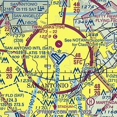
|
CAUTION: Diagram may not be current
 Download PDF
of official airport diagram from the FAA
| Airport distance calculator |
|---|
|
|
| Sunrise and sunset |
|---|
|
Times for 03-May-2026
| | Local
(UTC-5) | | Zulu
(UTC) |
|---|
| Morning civil twilight | | 06:26 | | 11:26 |
| Sunrise | | 06:51 | | 11:51 |
| Sunset | | 20:11 | | 01:11 |
| Evening civil twilight | | 20:36 | | 01:36 |
|
| Current date and time |
|---|
| Zulu (UTC) | 04-May-2026 00:09:59 |
|---|
| Local (UTC-5) | 03-May-2026 19:09:59 |
|---|
|
| METAR |
|---|
| KSAT | 032351Z 14011KT 10SM BKN250 24/08 A3004 RMK AO2 SLP158 T02440083 10256 20239 56022 $
|
KRND
11nm E | 032355Z AUTO 14009KT 10SM CLR 26/08 A3003 RMK AO2 SLP165 T02550080 10266 20242 56022
|
KSKF
11nm SW | 032355Z AUTO 15008KT 10SM CLR 26/07 A2999 RMK AO2 SLP152 T02640069 10269 20240 57024 $
|
KSSF
12nm S | 032353Z 13010KT 10SM CLR 26/09 A3001 RMK AO2 SLP156 T02560094 10267 20233 56024 $
|
K5C1
16nm NW | 032355Z AUTO 17009KT 10SM CLR 22/06 A3006 RMK AO1
|
|
| TAF |
|---|
| KSAT | 032057Z 0321/0424 13008KT P6SM FEW070 SCT250 FM040200 16007KT P6SM SCT025 BKN250 FM041600 18011G21KT P6SM FEW050 SCT250
|
KRND
11nm E | 040000Z 0400/0506 15010KT 9999 FEW250 QNH2999INS BECMG 0409/0410 17005KT 9999 FEW020 BKN100 BKN250 QNH2992INS BECMG 0415/0416 17012G20KT 9999 FEW040 SCT120 BKN250 QNH2975INS TX30/0421Z TN15/0412Z
|
KSKF
11nm SW | 031740Z 0318/0424 15012G18KT 9999 SCT250 QNH3000INS BECMG 0402/0403 15009KT 9999 BKN250 QNH2996INS BECMG 0414/0415 17012G18KT 9999 SCT050 QNH2977INS TX27/0322Z TN16/0412Z
|
KSSF
12nm S | 031720Z 0318/0418 16006KT P6SM FEW250 FM040100 14007KT P6SM SCT250 FM040700 16004KT P6SM OVC250 FM041400 18012G20KT P6SM BKN050
|
|
| NOTAMs |
|---|
NOTAMs are issued by the DoD/FAA and will open in a separate window not controlled by AirNav.
|
|


