FAA INFORMATION EFFECTIVE 25 DECEMBER 2025
Location
| FAA Identifier: | 5C1 |
| Lat/Long: | 29-43-23.5885N 098-41-40.4049W
29-43.393142N 098-41.673415W
29.7232190,-98.6945569
(estimated) |
| Elevation: | 1383.9 ft. / 421.8 m (surveyed) |
| Variation: | 05E (2010) |
| From city: | 20 miles NW of SAN ANTONIO, TX |
| Time zone: | UTC -6 (UTC -5 during Daylight Saving Time) |
| Zip code: | 78006 |
Airport Operations
| Airport use: | Open to the public |
| Activation date: | 04/1987 |
| Control tower: | no |
| ARTCC: | HOUSTON CENTER |
| FSS: | SAN ANGELO FLIGHT SERVICE STATION |
| NOTAMs facility: | SJT (NOTAM-D service available) |
| Attendance: | 0800-1700 |
| Wind indicator: | lighted |
| Segmented circle: | yes |
| Lights: | SS-SR |
| Beacon: | white-green (lighted land airport)
Operates sunset to sunrise. |
Airport Communications
| CTAF/UNICOM: | 123.0 |
| WX AWOS-3: | 118.725 (830-755-9099) |
| SAN ANTONIO APPROACH: | 125.1 |
| SAN ANTONIO DEPARTURE: | 125.1 |
| CRVZA RNAV STAR: | 125.7 |
| DNKIN RNAV STAR: | 125.1 |
| POPPO RNAV STAR: | 125.1 |
| QERVO RNAV STAR: | 127.1 |
| WX ASOS at SAT (16 nm SE): | PHONE 210-939-4003 |
Nearby radio navigation aids
| VOR radial/distance | | VOR name | | Freq | | Var |
|---|
| SATr283/13.1 | | SAN ANTONIO VORTAC | | 116.80 | | 08E |
| RNDr295/24.6 | | RANDOLPH VORTAC | | 112.30 | | 05E |
| STVr171/29.0 | | STONEWALL VORTAC | | 113.80 | | 08E |
| CSIr106/29.6 | | CENTER POINT VORTAC | | 117.50 | | 08E |
| SSFr332/(30.8) | | STINSON VOR | | 108.40 | | 03E |
| NDB name | | Hdg/Dist | | Freq | | Var | | ID |
|---|
| DEVINE | | 013/37.4 | | 359 | | 07E | | HHH | .... .... .... |
Airport Services
| Fuel available: | 100LL JET-A |
| Parking: | hangars and tiedowns |
| Airframe service: | MAJOR |
| Powerplant service: | MAJOR |
| Bottled oxygen: | LOW |
Runway Information
Runway 17/35
| Dimensions: | 5006 x 60 ft. / 1526 x 18 m |
| Surface: | asphalt, in excellent condition |
| Runway edge lights: | low intensity |
| RUNWAY 17 | | RUNWAY 35 |
| Latitude: | 29-43.803825N | | 29-42.982457N |
| Longitude: | 098-41.722775W | | 098-41.624055W |
| Elevation: | 1381.5 ft. | | 1375.4 ft. |
| Traffic pattern: | right | | left |
| Runway heading: | 169 magnetic, 174 true | | 349 magnetic, 354 true |
| Displaced threshold: | 629 ft. | | 1086 ft. |
| Markings: | nonprecision, in good condition | | nonprecision, in good condition |
| Touchdown point: | yes, no lights | | yes, no lights |
| Obstructions: | 8 ft. fence, 201 ft. from runway
8 FT FENCE,187 FT DSTC,82 FT R,30 FT LGTD PLINE, 152195 FT DSTC,82 FT R. | | 25 ft. trees, 201 ft. from runway, 82 ft. left of centerline
8 FT FENCE, 38 FT DSTC, 0 FT BOTH; 30 FT TREE, 40 FT DSTC, 75 FT L; 35 FT POLE LINE, 0-199 FT DSTC, 143 FT R, LGTD. |
Airport Ownership and Management from official FAA records
| Ownership: | Privately-owned |
| Owner: | BOERNE STAGE AIRFIELD, INC
400 BOERNE STAGE AIRFIELD
BOERNE, TX 78006
Phone 830-981-2345 |
| Manager: | KELBY COMBS
400 BOERNE STAGE AIRFIELD
BOERNE, TX 78006
Phone 830-981-2345 |
Additional Remarks
| - | NOISE ABATEMENT PROCEDURES IN EFFECT CTC AMGR. |
| - | USE EXTREME CTN WHEN OPRG INTO AND OUT OF 5C1 FOR OVER FLIGHT TFC LDG SAN ANTONIO INTL (KSAT) AT 3000 FT MSL AND ABV. SEE LTA-SAT-32. |
| - | LANDING FEES IN EFFECT |
| - | NO TGLS, STOP & GO OR LOW APCHS. |
| - | GLIDER ACT ON & INVOF ARPT. |
| - | ALL LNDG TURBINE ACFT MUST BE STAGE 3 OR BETTER. |
| - | RWY 35, 35 FT LGTD PWR POLES ACRS APCH. |
| - | FOR CD CTC SAN ANTONIO APCH AT 210-805-5516. |
Instrument Procedures
NOTE: All procedures below are presented as PDF files. If you need a reader for these files, you should download the free Adobe Reader.NOT FOR NAVIGATION. Please procure official charts for flight.
FAA instrument procedures published for use from 25 December 2025 at 0901z to 22 January 2026 at 0900z.
STARs - Standard Terminal Arrivals |
|---|
| CRVZA TWO (RNAV) **NEW** | |
2 pages:
[1] [2] (299KB) |
| CRVZA TWO (RNAV), CONT.2 **NEW** | |
download (205KB) |
| DNKIN TWO (RNAV) **NEW** | |
2 pages:
[1] [2] (439KB) |
| POPPO TWO (RNAV) **NEW** | |
2 pages:
[1] [2] (312KB) |
| POPPO TWO (RNAV), CONT.2 **NEW** | |
download (236KB) |
| QERVO THREE (RNAV) **NEW** | |
2 pages:
[1] [2] (386KB) |
| QERVO THREE (RNAV), CONT.2 **NEW** | |
download (272KB) |
IAPs - Instrument Approach Procedures |
|---|
| RNAV (GPS) RWY 17 | |
download (169KB) |
| RNAV (GPS) RWY 35 | |
download (178KB) |
| NOTE: Special Alternate Minimums apply | |
download (138KB) |
Departure Procedures |
|---|
| ALISS SEVEN (RNAV) | |
download (153KB) |
| SLENA TWO (RNAV) | |
download (155KB) |
| SNIDR TWO (RNAV) | |
download (225KB) |
| TJANO TWO (RNAV) | |
download (166KB) |
| YODUH TWO (RNAV) | |
download (185KB) |
| NOTE: Special Take-Off Minimums/Departure Procedures apply | |
download (303KB) |
Other nearby airports with instrument procedures:
KSAT - San Antonio International Airport (16 nm SE)
KSKF - Kelly Field Airport (21 nm S)
KCVB - Castroville Municipal Airport (24 nm S)
KRND - Randolph Air Force Base (25 nm SE)
KERV - Kerrville Municipal Airport/Louis Schreiner Field (25 nm NW)
|
|

Road maps at:
MapQuest
Bing
Google
| Aerial photo |
|---|
WARNING: Photo may not be current or correct
 Taken early January 2017
looking south.
Taken early January 2017
looking south.
Do you have a better or more recent aerial photo of Boerne Stage Airfield that you would like to share? If so, please send us your photo.
|
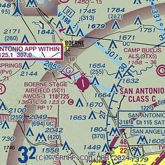
| Sectional chart |
|---|
|
CAUTION: Diagram may not be current

| Airport distance calculator |
|---|
|
|
| Sunrise and sunset |
|---|
|
Times for 08-Jan-2026
| | Local
(UTC-6) | | Zulu
(UTC) |
|---|
| Morning civil twilight | | 07:06 | | 13:06 |
| Sunrise | | 07:32 | | 13:32 |
| Sunset | | 17:51 | | 23:51 |
| Evening civil twilight | | 18:17 | | 00:17 |
|
| Current date and time |
|---|
| Zulu (UTC) | 08-Jan-2026 10:02:47 |
|---|
| Local (UTC-6) | 08-Jan-2026 04:02:47 |
|---|
|
| METAR |
|---|
| K5C1 | 080955Z AUTO 19011G19KT 10SM OVC012 18/18 A2978 RMK AO1
|
KSAT
16nm SE | 080951Z 17013G21KT 10SM BKN018 OVC250 20/17 A2977 RMK AO2 PK WND 16028/0911 SLP063 T02000172 $
|
|
| TAF |
|---|
KSAT
16nm SE | 080535Z 0806/0912 15012KT P6SM BKN018 BKN050 FM081200 18009KT P6SM BKN018 OVC050 FM081700 23007KT P6SM BKN050 FM090100 VRB03KT P6SM FEW050 SCT250
|
|
| NOTAMs |
|---|
NOTAMs are issued by the DoD/FAA and will open in a separate window not controlled by AirNav.
|
|


