FAA INFORMATION EFFECTIVE 09 JULY 2026
Location
| FAA Identifier: | SBY |
| Lat/Long: | 38-20-24.6820N 075-30-34.1210W
38-20.411367N 075-30.568683W
38.3401894,-75.5094781
(estimated) |
| Elevation: | 52.5 ft. / 16.0 m (surveyed) |
| Variation: | 12W (2000) |
| From city: | 4 miles SE of SALISBURY, MD |
| Time zone: | UTC -4 (UTC -5 during Standard Time) |
| Zip code: | 21804 |
Airport Operations
| Airport use: | Open to the public |
| Activation date: | 02/1944 |
| Control tower: | yes |
| ARTCC: | WASHINGTON CENTER |
| FSS: | LEESBURG FLIGHT SERVICE STATION |
| NOTAMs facility: | SBY (NOTAM-D service available) |
| Attendance: | 0430-0030 |
| Wind indicator: | lighted |
| Segmented circle: | no |
| Lights: | WHEN ATCT CLSD ACTVT MALSR RWY 32; REIL RWY 05, 14 & 23; MIRL RWY 05/23; HIRL RWY 14/32; TWY LGTS - CTAF. PAPI RWY 5, 14, 23 & 32 OPR CONSLY. |
| Beacon: | white-green (lighted land airport)
Operates sunset to sunrise. |
| Fire and rescue: | ARFF index B |
| Airline operations: | 24 HR PPR RQR FOR UNSKED ACR OPS CTC AMGR. |
Airport Communications
| CTAF: | 119.425 |
| UNICOM: | 122.95 |
| WX ASOS: | 118.325 (410-341-0868) |
| SALISBURY GROUND: | 123.775 [0600-2230] |
| SALISBURY TOWER: | 119.425 [0600-2230] |
| PATUXENT APPROACH: | 127.95 |
| POTOMAC APPROACH: | 127.2 ;WHEN NHK APCH CLSD |
| PATUXENT DEPARTURE: | 127.95 |
| POTOMAC DEPARTURE: | 127.2 ;WHEN NHK APCH CLSD |
| CLEARANCE DELIVERY: | 132.45 ;WHEN SBY TWR CLSD 123.775 ;0600-2230 |
| WX ASOS at OXB (18 nm E): | 119.025 (410-213-1530) |
- APCH/DEP SVC PRVDD BY POTOMAC TRACON APP/DEP CON 127.2/281.475 WHEN PATUXENT APCH CTL CLSD
Nearby radio navigation aids
| VOR radial/distance | | VOR name | | Freq | | Var |
|---|
| ATRr215/31.5 | | WATERLOO VOR/DME | | 112.60 | | 09W |
Airport Services
| Fuel available: | 100LL JET-A |
| Parking: | hangars and tiedowns |
| Airframe service: | MAJOR |
| Powerplant service: | MAJOR |
| Bottled oxygen: | NONE |
| Bulk oxygen: | NONE |
Runway Information
Runway 14/32
| Dimensions: | 6400 x 100 ft. / 1951 x 30 m |
| Surface: | asphalt/concrete/grooved, in good condition |
| Weight bearing capacity: | | Single wheel: | 76.0 | | Double wheel: | 126.0 | | Double tandem: | 423.0 | | Dual double tandem: | 749.0 |
|
| Runway edge lights: | high intensity |
| RUNWAY 14 | | RUNWAY 32 |
| Latitude: | 38-20.761323N | | 38-20.131530N |
| Longitude: | 075-31.001027W | | 075-29.927315W |
| Elevation: | 46.2 ft. | | 52.5 ft. |
| Traffic pattern: | left | | left |
| Runway heading: | 139 magnetic, 127 true | | 319 magnetic, 307 true |
| Declared distances: | TORA:6400 TODA:6400 ASDA:6400 LDA:6400 | | TORA:6400 TODA:6400 ASDA:6400 LDA:6400 |
| Markings: | nonprecision, in good condition | | precision, in good condition |
| Visual slope indicator: | 4-light PAPI on left (3.00 degrees glide path) | | 4-light PAPI on left (3.00 degrees glide path) |
| Approach lights: | | | MALSR: 1,400 foot medium intensity approach lighting system with runway alignment indicator lights |
| Runway end identifier lights: | yes | | |
| Touchdown point: | yes, no lights | | yes, no lights |
| Instrument approach: | | | ILS |
Runway 5/23
| Dimensions: | 5000 x 100 ft. / 1524 x 30 m |
| Surface: | asphalt/grooved, in excellent condition |
| Weight bearing capacity: | | Single wheel: | 56.0 | | Double wheel: | 76.0 | | Double tandem: | 142.0 |
|
| Runway edge lights: | medium intensity |
| RUNWAY 5 | | RUNWAY 23 |
| Latitude: | 38-20.036038N | | 38-20.696857N |
| Longitude: | 075-31.014770W | | 075-30.390215W |
| Elevation: | 44.1 ft. | | 49.4 ft. |
| Traffic pattern: | left | | left |
| Runway heading: | 049 magnetic, 037 true | | 229 magnetic, 217 true |
| Declared distances: | TORA:5000 TODA:5000 ASDA:5000 LDA:5000 | | TORA:5000 TODA:5000 ASDA:5000 LDA:5000 |
| Markings: | nonprecision, in good condition | | nonprecision, in good condition |
| Visual slope indicator: | 4-light PAPI on left (3.00 degrees glide path) | | 4-light PAPI on left (3.00 degrees glide path) |
| Runway end identifier lights: | yes | | yes |
| Touchdown point: | yes, no lights | | yes, no lights |
| Obstructions: | 95 ft. tree, 2920 ft. from runway, 190 ft. left of centerline, 28:1 slope to clear | | 95 ft. tree, 2800 ft. from runway, 27:1 slope to clear |
Airport Ownership and Management from official FAA records
| Ownership: | Publicly-owned |
| Owner: | WICOMICO COUNTY
PO BOX 870
SALISBURY, MD 21803
Phone 410-548-4801 |
| Manager: | ANTHONY RUDY
5485 AIRPORT TERMINAL RD, UNIT A
SALISBURY, MD 21804
Phone 410-548-4827 |
Additional Remarks
| A39-05/23 | PCR VALUE: 130/F/C/X/T |
| A39-14/32 | PCR VALUE: 400/F/D/X/T |
| - | MIL TRNG ACT, DEER & BIRDS ON & INVOF ARPT. |
| - | FOR CD CTC PATUXENT APCH AT 301-342-3740, WHEN PATUXENT APCH IS CLSD CTC POTOMAC APCH AT 866-640-4124. |
| - | RWY 32 NSDT REFLECTIVE LNDG ZONE MKR PANELS ADJ TO RWY. |
| - | TWY G SOUTH 950FT CLSD TO ACFT WINGSPAN MORE THAN 49 FT. |
| - | RWY 5 NONSTD REFLECTIVE LDG ZONE MKR PANELS ADJ TO THE RWY. |
| - | RWY 23 NONSTD REFLECTIVE LDG ZONE MKR PANELS ADJ TO THE RWY. |
| - | FBO HRS 0700-1900LCL. FOR SERVICES AFTER HRS CALL 410-749-0323. |
Instrument Procedures
NOTE: All procedures below are presented as PDF files. If you need a reader for these files, you should download the free Adobe Reader.NOT FOR NAVIGATION. Please procure official charts for flight.
FAA instrument procedures published for use from 09 July 2026 at 0901Z to 06 August 2026 at 0900Z.
IAPs - Instrument Approach Procedures |
|---|
| ILS OR LOC RWY 32 | |
download (225KB) |
| RNAV (GPS) RWY 05 | |
download (215KB) |
| RNAV (GPS) RWY 14 | |
download (253KB) |
| RNAV (GPS) RWY 23 | |
download (233KB) |
| RNAV (GPS) RWY 32 | |
download (219KB) |
| NOTE: Special Alternate Minimums apply | |
download (169KB) |
| NOTE: Special Take-Off Minimums/Departure Procedures apply | |
download (140KB) |
Other nearby airports with instrument procedures:
N06 - Laurel Airport (13 nm N)
KOXB - Ocean City Municipal Airport (18 nm E)
KGED - Delaware Coastal Airport (22 nm N)
KWAL - Wallops Flight Facility (24 nm S)
W41 - Crisfield-Somerset County Airport (24 nm SW)
|
|

Road maps at:
MapQuest
Bing
Google
| Aerial photo |
|---|
WARNING: Photo may not be current or correct
 Photo by David Newcomer
Photo taken 10-Sep-2019
looking south from 5,000'.
Photo by David Newcomer
Photo taken 10-Sep-2019
looking south from 5,000'.
Do you have a better or more recent aerial photo of Salisbury-Ocean City Wicomico Regional Airport that you would like to share? If so, please send us your photo.
|
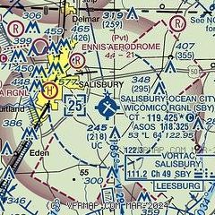
| Sectional chart |
|---|
|
CAUTION: Diagram may not be current
 Download PDF
of official airport diagram from the FAA
| Airport distance calculator |
|---|
|
|
| Sunrise and sunset |
|---|
|
Times for 19-Jul-2026
| | Local
(UTC-4) | | Zulu
(UTC) |
|---|
| Morning civil twilight | | 05:24 | | 09:24 |
| Sunrise | | 05:54 | | 09:54 |
| Sunset | | 20:22 | | 00:22 |
| Evening civil twilight | | 20:53 | | 00:53 |
|
| Current date and time |
|---|
| Zulu (UTC) | 20-Jul-2026 00:36:10 |
|---|
| Local (UTC-4) | 19-Jul-2026 20:36:10 |
|---|
|
| METAR |
|---|
| KSBY | 192354Z 13005KT 9SM BKN075 26/19 A2989 RMK AO2 SLP125 T02610189 10322 20261 53016
|
KOXB
19nm E | 192353Z AUTO 00000KT 6SM HZ FEW006 FEW042 24/21 A2989 RMK AO2 SLP120 T02440211 10278 20244 53008
|
|
| TAF |
|---|
| KSBY | 191720Z 1918/2018 34006KT P6SM FEW040 SCT250 FM200000 VRB04KT P6SM FEW040 FM201400 07007KT P6SM SCT040
|
|
| NOTAMs |
|---|
NOTAMs are issued by the DoD/FAA and will open in a separate window not controlled by AirNav.
|
|


