FAA INFORMATION EFFECTIVE 07 AUGUST 2025
Location
| FAA Identifier: | T69 |
| Lat/Long: | 28-02-18.8407N 097-32-33.0045W
28-02.314012N 097-32.550075W
28.0385669,-97.5425013
(estimated) |
| Elevation: | 47.9 ft. / 14.6 m (surveyed) |
| Variation: | 06E (2000) |
| From city: | 2 miles W of SINTON, TX |
| Time zone: | UTC -5 (UTC -6 during Standard Time) |
| Zip code: | 78387 |
Airport Operations
| Airport use: | Open to the public |
| Activation date: | 04/1945 |
| Control tower: | no |
| ARTCC: | HOUSTON CENTER |
| FSS: | SAN ANGELO FLIGHT SERVICE STATION |
| NOTAMs facility: | SJT (NOTAM-D service available) |
| Attendance: | 0730-1700 |
| Wind indicator: | lighted |
| Segmented circle: | yes |
| Lights: | ACTVT REIL RWY 14 & 32; MIRL RWY 14/32 - CTAF. |
| Beacon: | white-green (lighted land airport)
Operates sunset to sunrise. |
Airport Communications
| CTAF/UNICOM: | 122.8 |
| WX AWOS-3: | 118.25 (361-364-1844) |
| CORPUS APPROACH: | 120.9 |
| CORPUS DEPARTURE: | 120.9 |
| WX ASOS at CRP (16 nm S): | PHONE 361-267-5360 |
| WX AWOS-3 at RBO (17 nm SW): | 118.175 (361-767-1982) |
| WX AWOS-3 at TFP (19 nm SE): | 118.775 (361-758-8961) |
Nearby radio navigation aids
| VOR radial/distance | | VOR name | | Freq | | Var |
|---|
| CRPr318/9.6 | | CORPUS CHRISTI VORTAC | | 115.50 | | 09E |
| ALIr049/(31.1) | | ALICE VOR | | 114.50 | | 06E |
Airport Services
| Fuel available: | 100LL JET-A+
100LL:FOR FUEL OR SVC CALL 361-364-3200. AFT HRS CALL 361-548-1483 OR 361-364-2251. |
| Parking: | tiedowns |
| Airframe service: | MAJOR |
| Powerplant service: | MAJOR |
| Bottled oxygen: | NONE |
| Bulk oxygen: | NONE |
Runway Information
Runway 14/32
| Dimensions: | 4323 x 55 ft. / 1318 x 17 m |
| Surface: | asphalt, in fair condition |
| Weight bearing capacity: | |
| Runway edge lights: | medium intensity |
| RUNWAY 14 | | RUNWAY 32 |
| Latitude: | 28-02.649680N | | 28-02.059340N |
| Longitude: | 097-32.772160W | | 097-32.320793W |
| Elevation: | 46.2 ft. | | 46.5 ft. |
| Traffic pattern: | left | | left |
| Runway heading: | 140 magnetic, 146 true | | 320 magnetic, 326 true |
| Displaced threshold: | 250 ft. | | 400 ft. |
| Markings: | nonprecision, in good condition | | nonprecision, in good condition |
| Visual slope indicator: | 2-light PAPI on left (3.00 degrees glide path) | | 2-light PAPI on left (3.00 degrees glide path) |
| Runway end identifier lights: | yes | | yes |
| Touchdown point: | yes, no lights | | yes, no lights |
| Obstructions: | 20 ft. road, 201 ft. from runway, 195 ft. left of centerline
5 FT FENCE, 0 FT DSTC 220 FT L. | | 15 ft. road, 200 ft. from runway, 180 ft. right of centerline
3 FT FENCE AND 15 FT RD 0 FT DSTC, 110 FT L. |
Runway 3/21
| Dimensions: | 3100 x 50 ft. / 945 x 15 m |
| Surface: | turf/L
RWY NOT MNTND, NOT INSPD. UNA TO DTRM EXACT LCTN OF RWY. |
| Operational restrictions: | RWY 03/21 CLSD INDEFLY. |
| RUNWAY 3 | | RUNWAY 21 |
| Latitude: | 28-02.064192N | | 28-02.450883N |
| Longitude: | 097-32.743833W | | 097-32.366350W |
| Elevation: | 47.0 ft. | | 47.0 ft. |
| Traffic pattern: | left | | left |
| Runway heading: | 035 magnetic, 041 true | | 215 magnetic, 221 true |
| Touchdown point: | yes, no lights | | yes, no lights |
| Obstructions: | 15 ft. road, 78 ft. from runway, 5:1 slope to clear | | 35 ft. pline, lighted, 400 ft. from runway, 11:1 slope to clear |
Airport Ownership and Management from official FAA records
| Ownership: | Publicly-owned |
| Owner: | SAN PATRICIO COUNTY
SAN PATRICIO COUNTY COURTHOUSE, 1301 E SINTON
SINTON, TX 78387
Phone 361-364-9300 |
| Manager: | GARY LEE DAVIS
3141 FM 3512
ARANSAS PASS, TX 78336
Phone 361-226-0112
GDAVIS@SANPATRICIOCOUNTYTX.GOV |
Additional Remarks
| - | FOR CD CTC CORPUS CHRISTI APCH AT 361-299-4230. |
Instrument Procedures
NOTE: All procedures below are presented as PDF files. If you need a reader for these files, you should download the free Adobe Reader.NOT FOR NAVIGATION. Please procure official charts for flight.
FAA instrument procedures published for use from 07 August 2025 at 0901Z to 04 September 2025 at 0900z.
IAPs - Instrument Approach Procedures |
|---|
| RNAV (GPS) RWY 14 **CHANGED** | |
download (175KB) |
| RNAV (GPS) RWY 32 **CHANGED** | |
download (179KB) |
| VOR RWY 14 **CHANGED** | |
download (195KB) |
| NOTE: Special Alternate Minimums apply | |
download (139KB) |
| NOTE: Special Take-Off Minimums/Departure Procedures apply | |
download (300KB) |
Other nearby airports with instrument procedures:
KCRP - Corpus Christi International Airport (16 nm S)
KRBO - Nueces County Airport (17 nm SW)
KTFP - Ingleside Regional Airport (19 nm SE)
TX2 - Chase Field Industrial Airport (20 nm N)
KBEA - Beeville Municipal Airport (24 nm NW)
|
|

Road maps at:
MapQuest
Bing
Google
| Aerial photo |
|---|
WARNING: Photo may not be current or correct

Do you have a better or more recent aerial photo of Sinton Airport that you would like to share? If so, please send us your photo.
|
| Sectional chart |
|---|
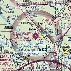
|
| Airport distance calculator |
|---|
|
|
| Sunrise and sunset |
|---|
|
Times for 20-Aug-2025
| | Local
(UTC-5) | | Zulu
(UTC) |
|---|
| Morning civil twilight | | 06:39 | | 11:39 |
| Sunrise | | 07:04 | | 12:04 |
| Sunset | | 20:03 | | 01:03 |
| Evening civil twilight | | 20:28 | | 01:28 |
|
| Current date and time |
|---|
| Zulu (UTC) | 20-Aug-2025 22:03:26 |
|---|
| Local (UTC-5) | 20-Aug-2025 17:03:26 |
|---|
|
| METAR |
|---|
| KT69 | 202155Z AUTO 9SM CLR 36/24 A2985 RMK A01
|
KCRP
16nm S | 202151Z 10012G19KT 10SM FEW035 FEW065 FEW250 35/22 A2986 RMK AO2 SLP108 FRQ LTGCG DSNT NW-N CB DSNT NW-N SW W-NW MOV SW TCU DSNT N NE S SW W NW T03500217
|
KRBO
17nm SW | 202155Z AUTO 07009KT 10SM CLR 37/22 A2986 RMK AO2 T03660221
|
KTFP
19nm SE | 202135Z AUTO 15010G15KT 10SM CLR 36/22 A2986 RMK AO1 T03560221
|
|
| TAF |
|---|
KCRP
16nm S | 201728Z 2018/2118 01005KT P6SM FEW035 BKN250 FM202000 09011KT P6SM SCT040 BKN250 FM210300 VRB04KT P6SM SCT250
|
|
| NOTAMs |
|---|
NOTAMs are issued by the DoD/FAA and will open in a separate window not controlled by AirNav.
|
|

