FAA INFORMATION EFFECTIVE 16 APRIL 2026
Location
| FAA Identifier: | BEA |
| Lat/Long: | 28-21-51.2000N 097-47-31.0000W
28-21.853333N 097-47.516667W
28.3642222,-97.7919444
(estimated) |
| Elevation: | 272.8 ft. / 83.1 m (surveyed) |
| Variation: | 04E (2020) |
| From city: | 3 miles SW of BEEVILLE, TX |
| Time zone: | UTC -5 (UTC -6 during Standard Time) |
| Zip code: | 78102 |
Airport Operations
| Airport use: | Open to the public |
| Activation date: | 12/1966 |
| Control tower: | no |
| ARTCC: | HOUSTON CENTER |
| FSS: | SAN ANGELO FLIGHT SERVICE STATION |
| NOTAMs facility: | BEA (NOTAM-D service available) |
| Attendance: | UNATNDD |
| Wind indicator: | lighted |
| Segmented circle: | yes |
| Lights: | SS-SR MIRL RY 12/30 PRESET LOW INTST; TO INCR INTST ACTVT - CTAF. |
| Beacon: | white-green (lighted land airport)
Operates sunset to sunrise. |
Airport Communications
| CTAF/UNICOM: | 122.8 |
| WX AWOS-3: | 118.675 (361-362-7627) |
| WX AWOS-3PT at 8T6 (17 nm W): | 119.05 (361-449-1119) |
| WX ASOS at NGT (18 nm NE): | 353.675 |
- APCH/DEP CTL SVC PRVDD BY HOUSTON ARTCC (ZHU) ON FREQS 134.6/322.5 (THREE RIVERS RCAG).
Nearby radio navigation aids
| VOR radial/distance | | VOR name | | Freq | | Var |
|---|
| CRPr317/33.2 | | CORPUS CHRISTI VORTAC | | 115.50 | | 09E |
| ALIr012/(39.4) | | ALICE VOR | | 114.50 | | 06E |
Airport Services
| Fuel available: | 100LL JET-A+
100LL:FUEL 24 HR SELF SERV. |
| Parking: | tiedowns |
| Airframe service: | MINOR |
| Powerplant service: | MINOR |
| Bottled oxygen: | NONE |
| Bulk oxygen: | NONE |
Runway Information
Runway 12/30
| Dimensions: | 4553 x 75 ft. / 1388 x 23 m |
| Surface: | asphalt, in good condition |
| Weight bearing capacity: | |
| Runway edge lights: | medium intensity |
| RUNWAY 12 | | RUNWAY 30 |
| Latitude: | 28-21.958203N | | 28-21.465768N |
| Longitude: | 097-47.782273W | | 097-47.140877W |
| Elevation: | 268.2 ft. | | 244.0 ft. |
| Traffic pattern: | left | | left |
| Runway heading: | 127 magnetic, 131 true | | 307 magnetic, 311 true |
| Markings: | nonprecision, in good condition | | nonprecision, in good condition |
| Visual slope indicator: | 2-light PAPI on left (3.00 degrees glide path) | | 2-light PAPI on left (3.00 degrees glide path) |
| Touchdown point: | yes, no lights | | yes, no lights |
| Obstructions: | 15 ft. road, 260 ft. from runway, 260 ft. right of centerline, 4:1 slope to clear
ALSO 30 FT PLINE, 464 FT DSTC, 295 FT R, OBSTN CLNC SLOPE 8:1. ALSO 30 FT PLINE, 445 FT DSTC, 290 FT R, OBSTN CLNC SLOPE 8:1. | | 15 ft. road, 258 ft. from runway, 264 ft. left of centerline, 3:1 slope to clear |
Runway 18/36
| Dimensions: | 2251 x 60 ft. / 686 x 18 m |
| Surface: | turf, in good condition |
| Runway edge markings: | MKD WITH 3 FT YELLOW CONES. |
| RUNWAY 18 | | RUNWAY 36 |
| Latitude: | 28-22.320082N | | 28-21.953513N |
| Longitude: | 097-47.591578W | | 097-47.659738W |
| Elevation: | 272.3 ft. | | 265.2 ft. |
| Traffic pattern: | left | | left |
| Runway heading: | 185 magnetic, 189 true | | 005 magnetic, 009 true |
| Touchdown point: | yes, no lights | | yes, no lights |
| Obstructions: | 20 ft. pline, marked, 450 ft. from runway, 200 ft. right of centerline, 22:1 slope to clear | | 21 ft. pline, marked, 675 ft. from runway, 180 ft. left of centerline, 32:1 slope to clear |
Airport Ownership and Management from official FAA records
| Ownership: | Publicly-owned |
| Owner: | CITY OF BEEVILLE
400 N. WASHINGTON
BEEVILLE, TX 78102
Phone 361-358-4641 |
| Manager: | JOHN BENSON
400 N. WASHINGTON
BEEVILLE, TX 78102
Phone 361-358-4641
AMGR CELL: 361-742-7725 |
Additional Remarks
| - | FOR CD CTC HOUSTON ARTCC AT 281-230-5622. |
| - | ON SITE ATTENDANT TIM FITCH, TIMAFITCH@GMAIL.COM, 361-319-3448. ALSO LARRY CLINE 361-542-6544. |
Instrument Procedures
NOTE: All procedures below are presented as PDF files. If you need a reader for these files, you should download the free Adobe Reader.NOT FOR NAVIGATION. Please procure official charts for flight.
FAA instrument procedures published for use from 16 April 2026 at 0901Z to 14 May 2026 at 0900Z.
IAPs - Instrument Approach Procedures |
|---|
| RNAV (GPS) RWY 12 | |
download (209KB) |
| RNAV (GPS) RWY 30 | |
download (204KB) |
| NOTE: Special Alternate Minimums apply | |
download (139KB) |
| NOTE: Special Take-Off Minimums/Departure Procedures apply | |
download (147KB) |
Other nearby airports with instrument procedures:
TX2 - Chase Field Industrial Airport (7 nm E)
8T6 - Live Oak County Airport (17 nm W)
KNGT - Goliad Naval Outlying Field (18 nm NE)
T69 - Sinton Airport (24 nm SE)
2R9 - Kenedy Regional Airport (28 nm N)
|
|

Road maps at:
MapQuest
Bing
Google
| Aerial photo |
|---|
WARNING: Photo may not be current or correct

Do you have a better or more recent aerial photo of Beeville Municipal Airport that you would like to share? If so, please send us your photo.
|
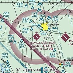
| Sectional chart |
|---|
|
| Airport distance calculator |
|---|
|
|
| Sunrise and sunset |
|---|
|
Times for 07-May-2026
| | Local
(UTC-5) | | Zulu
(UTC) |
|---|
| Morning civil twilight | | 06:22 | | 11:22 |
| Sunrise | | 06:47 | | 11:47 |
| Sunset | | 20:08 | | 01:08 |
| Evening civil twilight | | 20:34 | | 01:34 |
|
| Current date and time |
|---|
| Zulu (UTC) | 08-May-2026 02:37:32 |
|---|
| Local (UTC-5) | 07-May-2026 21:37:32 |
|---|
|
| METAR |
|---|
| KBEA | 080215Z AUTO 06006KT 10SM OVC023 22/16 A2992 RMK AO2 T02170156
|
|
| TAF |
|---|
KCRP
39nm SE | 071730Z 0718/0818 06011KT P6SM SCT010 OVC015 FM080500 VRB05KT 5SM BR VCSH OVC008 FM081500 09006KT P6SM SCT010 OVC015
|
KALI
40nm S | 071730Z 0718/0818 05010KT P6SM OVC015 FM072100 06009KT P6SM BKN025 FM080500 VRB05KT 4SM BR VCSH OVC008 FM081500 05006KT P6SM SCT010 OVC015
|
|
| NOTAMs |
|---|
NOTAMs are issued by the DoD/FAA and will open in a separate window not controlled by AirNav.
|
|

