FAA INFORMATION EFFECTIVE 22 JANUARY 2026
Location
| FAA Identifier: | 8T6 |
| Lat/Long: | 28-21-46.1000N 098-06-59.3000W
28-21.768333N 098-06.988333W
28.3628056,-98.1164722
(estimated) |
| Elevation: | 128.7 ft. / 39.2 m (surveyed) |
| Variation: | 03E (2025) |
| From city: | 2 miles N of GEORGE WEST, TX |
| Time zone: | UTC -6 (UTC -5 during Daylight Saving Time) |
| Zip code: | 78022 |
Airport Operations
| Airport use: | Open to the public |
| Activation date: | 08/1987 |
| Control tower: | no |
| ARTCC: | HOUSTON CENTER |
| FSS: | SAN ANGELO FLIGHT SERVICE STATION |
| NOTAMs facility: | SJT (NOTAM-D service available) |
| Attendance: | UNATNDD |
| Wind indicator: | lighted |
| Segmented circle: | yes |
| Lights: | DUSK-DAWN. MIRL RWY 13/31 PRESET LOW INTST; TO INCR INTST ACTVT - 122.7. |
| Beacon: | white-green (lighted land airport)
Operates sunset to sunrise. |
Airport Communications
| CTAF: | 122.9 |
| WX AWOS-3PT: | 119.05 (361-449-1119) |
| WX AWOS-3 at BEA (17 nm E): | 118.675 (361-362-7627) |
- APCH/DEP CTL SVC PRVDD BY HOUSTON ARTCC (ZHU) ON FREQS 134.6/322.5 (THREE RIVERS RCAG).
Nearby radio navigation aids
| VOR radial/distance | | VOR name | | Freq | | Var |
|---|
| ALIr346/(37.7) | | ALICE VOR | | 114.50 | | 06E |
Airport Services
| Fuel available: | 100LL JET-A
100LL:FUEL SELF-SERVE. |
| Parking: | tiedowns |
Runway Information
Runway 13/31
| Dimensions: | 3799 x 60 ft. / 1158 x 18 m |
| Surface: | asphalt, in excellent condition |
| Runway edge lights: | medium intensity |
| RUNWAY 13 | | RUNWAY 31 |
| Latitude: | 28-21.992843N | | 28-21.543492N |
| Longitude: | 098-07.235195W | | 098-06.740932W |
| Elevation: | 128.4 ft. | | 125.4 ft. |
| Traffic pattern: | left | | left |
| Runway heading: | 133 magnetic, 136 true | | 313 magnetic, 316 true |
| Markings: | nonprecision, in fair condition | | nonprecision, in fair condition |
| Visual slope indicator: | 2-light PAPI on left (3.00 degrees glide path) | | 2-light PAPI on left (3.00 degrees glide path) |
| Touchdown point: | yes, no lights | | yes, no lights |
| Obstructions: | 50 ft. pline, 1361 ft. from runway, 264 ft. right of centerline, 23:1 slope to clear | | none |
Airport Ownership and Management from official FAA records
| Ownership: | Publicly-owned |
| Owner: | LIVE OAK COUNTY
301 HOUSTON ST, PO BOX 487
GEORGE WEST, TX 78022
Phone 361-449-2733 |
| Manager: | JAMES LISKA
301 HOUSTON ST, PO BOX 487
GEORGE WEST, TX 78022
Phone 361-449-8002
COUNTY JUDGE |
Additional Remarks
| - | BIRDS ON & INVOF ARPT. |
| - | FOR CD CTC HOUSTON ARTCC AT 281-230-5622. |
| - | 75 FT ELEC TRANSMISSION LINE, 600 FT W OF AND PARL TO RWY CNTRLN, FULL LEN. |
| - | FOR ASSISTANCE OR HNGR CALL 361-449-2559 OR 361-449-6315 (CELL). |
| - | (CONTACT PHONE NR) LTDAVIS@LIVE.COM ALT 361-449-2093 |
Instrument Procedures
NOTE: All procedures below are presented as PDF files. If you need a reader for these files, you should download the free Adobe Reader.NOT FOR NAVIGATION. Please procure official charts for flight.
FAA instrument procedures published for use from 22 January 2026 at 0901Z to 19 February 2026 at 0900z.
IAPs - Instrument Approach Procedures |
|---|
| RNAV (GPS) RWY 13 | |
download (165KB) |
| NOTE: Special Alternate Minimums apply | |
download (141KB) |
| NOTE: Special Take-Off Minimums/Departure Procedures apply | |
download (312KB) |
Other nearby airports with instrument procedures:
KBEA - Beeville Municipal Airport (17 nm E)
TX2 - Chase Field Industrial Airport (24 nm E)
KNOG - Orange Grove Naval Auxiliary Field (28 nm S)
KNGT - Goliad Naval Outlying Field (30 nm NE)
2R9 - Kenedy Regional Airport (31 nm NE)
|
|

Road maps at:
MapQuest
Bing
Google
| Aerial photo |
|---|
WARNING: Photo may not be current or correct
 Photo taken 01-Mar-2016
looking east.
Photo taken 01-Mar-2016
looking east.
Do you have a better or more recent aerial photo of Live Oak County Airport that you would like to share? If so, please send us your photo.
|
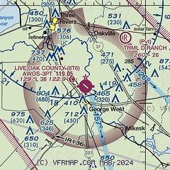
| Sectional chart |
|---|
|
| Airport distance calculator |
|---|
|
|
| Sunrise and sunset |
|---|
|
Times for 17-Feb-2026
| | Local
(UTC-6) | | Zulu
(UTC) |
|---|
| Morning civil twilight | | 06:46 | | 12:46 |
| Sunrise | | 07:10 | | 13:10 |
| Sunset | | 18:23 | | 00:23 |
| Evening civil twilight | | 18:47 | | 00:47 |
|
| Current date and time |
|---|
| Zulu (UTC) | 18-Feb-2026 01:44:37 |
|---|
| Local (UTC-6) | 17-Feb-2026 19:44:37 |
|---|
|
| METAR |
|---|
KBEA
17nm E | 180135Z AUTO 15011G18KT 10SM CLR 21/16 A2986 RMK AO2 T02120156 PWINO
|
KNOG
28nm S | 180056Z AUTO 09018G25KT CLR 23/18 A2985 RMK AO2 PK WND 10028/0036 SLP087 T02280178 PNO $
|
K2R9
31nm NE | 180135Z AUTO 14014G20KT 10SM CLR 22/17 A2985 RMK AO2
|
|
| TAF |
|---|
KALI
38nm S | 171740Z 1718/1818 16016G25KT P6SM FEW250 FM180200 15013KT P6SM FEW250 FM180500 15009KT P6SM SCT015 BKN250 TEMPO 1809/1813 12004KT 2SM BR SCT007 BKN015
|
|
| NOTAMs |
|---|
NOTAMs are issued by the DoD/FAA and will open in a separate window not controlled by AirNav.
|
|

