FAA INFORMATION EFFECTIVE 15 MAY 2025
Location
| FAA Identifier: | TTA |
| Lat/Long: | 35-34-56.7820N 079-06-04.8160W
35-34.946367N 079-06.080267W
35.5824394,-79.1013378
(estimated) |
| Elevation: | 246.6 ft. / 75.2 m (surveyed) |
| Variation: | 08W (2000) |
| From city: | 7 miles NE of SANFORD, NC |
| Time zone: | UTC -4 (UTC -5 during Standard Time) |
| Zip code: | 27330 |
Airport Operations
| Airport use: | Open to the public |
| Activation date: | 07/1999 |
| Control tower: | no |
| ARTCC: | WASHINGTON CENTER |
| FSS: | RALEIGH FLIGHT SERVICE STATION |
| NOTAMs facility: | TTA (NOTAM-D service available) |
| Attendance: | 0800-1800
FOR SVC AFTER HOURS CALL 919-708-3065. |
| Wind indicator: | lighted |
| Segmented circle: | yes |
| Lights: | DUSK-DAWN. ACTVT MALSR RWY 03; REIL RWY 21; HIRL RWY 03/21 - CTAF. PAPI RWYS 03 & 21 ON CONSLY. |
| Beacon: | white-green (lighted land airport)
Operates sunset to sunrise. |
Airport Communications
| CTAF/UNICOM: | 123.075 |
| WX AWOS-3: | 120.625 (919-708-5382) |
| RALEIGH APPROACH: | 125.3 |
| RALEIGH DEPARTURE: | 125.3 |
Nearby radio navigation aids
| VOR radial/distance | | VOR name | | Freq | | Var |
|---|
| RDUr231/23.3 | | RALEIGH/DURHAM VORTAC | | 117.20 | | 09W |
| LIBr122/28.5 | | LIBERTY VORTAC | | 113.00 | | 03W |
| SDZr050/32.4 | | SANDHILLS VORTAC | | 111.80 | | 03W |
| FAYr347/37.5 | | FAYETTEVILLE VOR/DME | | 114.85 | | 04W |
| NDB name | | Hdg/Dist | | Freq | | Var | | ID |
|---|
| HARNETT | | 301/22.7 | | 417 | | 08W | | HQT | .... --.- - |
Airport Services
| Fuel available: | 100LL JET-A1+
100LL:100LL 24 HR SELF-SERVICE WITH CREDIT CARD. |
| Parking: | tiedowns |
| Airframe service: | MAJOR |
| Powerplant service: | MAJOR |
| Bottled oxygen: | HIGH |
Runway Information
Runway 3/21
| Dimensions: | 6501 x 100 ft. / 1982 x 30 m |
| Surface: | asphalt, in excellent condition |
| Weight bearing capacity: | | Single wheel: | 30.0 | | Double wheel: | 100.0 |
|
| Runway edge lights: | high intensity |
| RUNWAY 3 | | RUNWAY 21 |
| Latitude: | 35-34.446217N | | 35-35.446510N |
| Longitude: | 079-06.315347W | | 079-05.845150W |
| Elevation: | 246.5 ft. | | 224.2 ft. |
| Traffic pattern: | left | | left |
| Runway heading: | 029 magnetic, 021 true | | 209 magnetic, 201 true |
| Markings: | precision, in good condition | | nonprecision, in good condition |
| Visual slope indicator: | 4-light PAPI on left (3.00 degrees glide path) | | 4-light PAPI on left (3.00 degrees glide path) |
| Approach lights: | MALSR: 1,400 foot medium intensity approach lighting system with runway alignment indicator lights | | |
| Runway end identifier lights: | no | | yes |
| Touchdown point: | yes, no lights | | yes, no lights |
| Instrument approach: | ILS/DME | | |
| Obstructions: | 58 ft. trees, 2493 ft. from runway, 174 ft. right of centerline, 39:1 slope to clear | | 71 ft. trees, 2194 ft. from runway, 142 ft. left of centerline, 28:1 slope to clear |
Airport Ownership and Management from official FAA records
| Ownership: | Publicly-owned |
| Owner: | SANFORD-LEE COUNTY RGNL ARPT AUTH
700 ROD SULLIVAN RD
SANFORD, NC 27330
Phone 919-776-2939 |
| Manager: | BOB HEUTS
700 ROD SULLIVAN RD.
SANFORD, NC 27330
Phone 919-776-2939 |
Additional Remarks
| - | FOR CD CTC RALEIGH APCH AT 919-380-3144. |
| - | USE RWY 03 FOR CALM WIND RWY. |
| - | TWY A 15-30 FT DROP-OFF INVOF TWYS A3 AND A4. |
Instrument Procedures
NOTE: All procedures below are presented as PDF files. If you need a reader for these files, you should download the free Adobe Reader.NOT FOR NAVIGATION. Please procure official charts for flight.
FAA instrument procedures published for use from 15 May 2025 at 0901Z to 13 June 2025 at 0900z.
IAPs - Instrument Approach Procedures |
|---|
| ILS Y OR LOC Y RWY 03 | |
download (299KB) |
| ILS Z OR LOC Z RWY 03 | |
download (364KB) |
| RNAV (GPS) RWY 03 | |
download (299KB) |
| RNAV (GPS) RWY 21 | |
download (283KB) |
| NOTE: Special Alternate Minimums apply | |
download (166KB) |
| NOTE: Special Take-Off Minimums/Departure Procedures apply | |
download (364KB) |
Other nearby airports with instrument procedures:
KSCR - Siler City Municipal Airport (21 nm W)
KHRJ - Harnett Regional Jetport Airport (22 nm SE)
KRDU - Raleigh-Durham International Airport (23 nm NE)
KSOP - Moore County Airport (25 nm SW)
KPOB - Pope Army Airfield (25 nm S)
|
|

Road maps at:
MapQuest
Bing
Google
| Aerial photo |
|---|
WARNING: Photo may not be current or correct
 Photo by Don Poitras
Do you have a better or more recent aerial photo of Raleigh Executive Jetport at Sanford-Lee County Airport that you would like to share? If so, please send us your photo.
|
| Sectional chart |
|---|
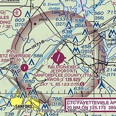
|
CAUTION: Diagram may not be current

| Airport distance calculator |
|---|
|
|
| Sunrise and sunset |
|---|
|
Times for 23-May-2025
| | Local
(UTC-4) | | Zulu
(UTC) |
|---|
| Morning civil twilight | | 05:38 | | 09:38 |
| Sunrise | | 06:07 | | 10:07 |
| Sunset | | 20:19 | | 00:19 |
| Evening civil twilight | | 20:48 | | 00:48 |
|
| Current date and time |
|---|
| Zulu (UTC) | 23-May-2025 22:26:19 |
|---|
| Local (UTC-4) | 23-May-2025 18:26:19 |
|---|
|
| METAR |
|---|
| KTTA | 232215Z AUTO 29006KT 10SM CLR 23/05 A3000 RMK AO2 T02340049
|
|
| TAF |
|---|
KRDU
23nm NE | 231722Z 2318/2418 29010G18KT P6SM SCT060 FM240000 32003KT P6SM SCT250
|
KPOB
25nm S | 231700Z 2317/2423 30015G20KT 9999 FEW050 QNH3000INS BECMG 2322/2323 30009KT 9999 FEW050 FEW120 QNH2999INS TX25/2319Z TN11/2410Z
|
|
| NOTAMs |
|---|
NOTAMs are issued by the DoD/FAA and will open in a separate window not controlled by AirNav.
|
|


