FAA INFORMATION EFFECTIVE 02 OCTOBER 2025
Location
| FAA Identifier: | UIN |
| Lat/Long: | 39-56-32.1910N 091-11-32.6560W
39-56.536517N 091-11.544267W
39.9422753,-91.1924044
(estimated) |
| Elevation: | 768.7 ft. / 234.3 m (surveyed) |
| Variation: | 02E (1985) |
| From city: | 10 miles E of QUINCY, IL |
| Time zone: | UTC -5 (UTC -6 during Standard Time) |
| Zip code: | 62301 |
Airport Operations
| Airport use: | Open to the public |
| Activation date: | 04/1947 |
| Control tower: | no |
| ARTCC: | KANSAS CITY CENTER |
| FSS: | SAINT LOUIS FLIGHT SERVICE STATION |
| NOTAMs facility: | UIN (NOTAM-D service available) |
| Attendance: | MON-FRI 0600-2000, ALL SAT 0600-2000, ALL SUN 0600-2000
FOR FUEL ATTENDANT OTR HRS CALL 217-885-3353 OR 217-779-5091. ACFT MAINT TO COORD CALL 217-885-3353. |
| Wind indicator: | lighted |
| Segmented circle: | yes |
| Lights: | ACTVT MALSR RWY 04; REIL RWY 22; PAPI RWY 13, 31, 04 & 22; HIRL RWY 04/22; MIRL RWY 13/31 - CTAF. HIRL RWY 04/22 PRESET LOW INTST; TO INCR INTST - CTAF. |
| Beacon: | white-green (lighted land airport)
Operates sunset to sunrise. |
| Fire and rescue: | ARFF index A |
Airport Communications
| CTAF/UNICOM: | 123.0 |
| WX ASOS: | 121.425 (217-885-3319) |
| WX AWOS-3PT at HAE (17 nm SW): | 120.775 (573-600-5226) |
| WX AWOS-3PT at I63 (18 nm E): | 118.325 (217-773-4082) |
- APCH/DEP SVC PRVDD BY KANSAS CITY ARTCC ON FREQS 126.225/317.775 (QUINCY RCAG).
Nearby radio navigation aids
| NDB name | | Hdg/Dist | | Freq | | Var | | ID |
|---|
| QUINCY | | 038/4.4 | | 293 | | 02E | | UI | ..- .. |
Airport Services
| Fuel available: | 100LL JET-A |
| Parking: | tiedowns |
| Airframe service: | MAJOR |
| Powerplant service: | MAJOR |
Runway Information
Runway 4/22
| Dimensions: | 7098 x 150 ft. / 2163 x 46 m |
| Surface: | asphalt/grooved, in fair condition |
| Weight bearing capacity: | | Single wheel: | 120.0 | | Double wheel: | 250.0 | | Double tandem: | 550.0 | | Dual double tandem: | 1120.0 |
|
| Runway edge lights: | high intensity |
| RUNWAY 4 | | RUNWAY 22 |
| Latitude: | 39-56.168702N | | 39-57.060112N |
| Longitude: | 091-11.973767W | | 091-10.991162W |
| Elevation: | 760.9 ft. | | 746.8 ft. |
| Traffic pattern: | left | | left |
| Runway heading: | 038 magnetic, 040 true | | 218 magnetic, 220 true |
| Declared distances: | TORA:7098 TODA:7098 ASDA:7098 LDA:7098 | | TORA:7098 TODA:7098 ASDA:7098 LDA:7098 |
| Markings: | precision, in good condition | | precision, in good condition |
| Visual slope indicator: | 4-light PAPI on right (3.00 degrees glide path) | | 4-light PAPI on left (3.00 degrees glide path) |
| Approach lights: | MALSR: 1,400 foot medium intensity approach lighting system with runway alignment indicator lights | | |
| Runway end identifier lights: | | | yes |
| Touchdown point: | yes, no lights | | yes, no lights |
| Instrument approach: | ILS | | |
| Obstructions: | 16 ft. road, 848 ft. from runway, 586 ft. right of centerline, 40:1 slope to clear | | none |
Runway 13/31
| Dimensions: | 5397 x 150 ft. / 1645 x 46 m |
| Surface: | asphalt/grooved, in fair condition |
| Weight bearing capacity: | | Single wheel: | 120.0 | | Double wheel: | 250.0 | | Double tandem: | 550.0 | | Dual double tandem: | 1081.0 |
|
| Runway edge lights: | medium intensity |
| RUNWAY 13 | | RUNWAY 31 |
| Latitude: | 39-56.750087N | | 39-56.118017N |
| Longitude: | 091-12.031505W | | 091-11.219522W |
| Elevation: | 765.2 ft. | | 768.4 ft. |
| Traffic pattern: | left | | left |
| Runway heading: | 133 magnetic, 135 true | | 313 magnetic, 315 true |
| Declared distances: | TORA:5397 TODA:5397 ASDA:5123 LDA:5123 | | TORA:5397 TODA:5397 ASDA:5146 LDA:5146 |
| Markings: | nonprecision, in good condition | | nonprecision, in good condition |
| Visual slope indicator: | 4-light PAPI on left (3.00 degrees glide path)
PAPI UNUSBL BYD 9 DEGS RIGHT OF CNTRLN. | | 4-light PAPI on right (3.00 degrees glide path) |
| Runway end identifier lights: | no | | no |
| Touchdown point: | yes, no lights | | yes, no lights |
| Obstructions: | 11 ft. road, 525 ft. from runway, 300 ft. right of centerline, 29:1 slope to clear | | 15 ft. pole, 800 ft. from runway, 200 ft. left of centerline, 40:1 slope to clear |
Airport Ownership and Management from official FAA records
| Ownership: | Publicly-owned |
| Owner: | CITY OF QUINCY
1645 HWY 104
QUINCY, IL 62305
Phone 217-885-3285
EXT: 8. |
| Manager: | BILL LANTZ
1645 HWY 104
QUINCY, IL 62305
Phone 217-885-3285
EMAIL ADDRESS: QUINCYAIRPORT@QUINCYIL.GOV |
Additional Remarks
| A39-13/31 | PCR VALUE: 1310/F/D/X/T |
| A39-04/22 | PCR VALUE: 1500/F/D/X/T |
| - | MIGRATORY WATERFOWL ON & INVOF ARPT. |
| - | FICON ARE NOT MONITORED BTWN THE HRS OF 2100-0500. |
| - | ARPT WDI OTS INDEFLY. |
| - | USE CTN; NO LINE OF SIGHT BTWN RWY ENDS DUE TO TOPOGRAPHY AND BLDG OBSTNS; ALL DEP/ARR ACFT USE CTAF 123.0. |
| - | FOR CD IF UNA TO CTC ON FSS FREQ, CTC KANSAS CITY ARTCC AT 913-254-8508. |
| - | ARFF NOT AVBL 24 HRS. 24 HRS PPR FOR UNSKED ACFT OPS; CTC ARPT MGR 217-885-3285 OR 217-885-3262. |
| - | RWY 04 IS THE PREFERRED RWY IN CALM WIND CONDITIONS. |
Instrument Procedures
NOTE: All procedures below are presented as PDF files. If you need a reader for these files, you should download the free Adobe Reader.NOT FOR NAVIGATION. Please procure official charts for flight.
FAA instrument procedures published for use from 02 October 2025 at 0901Z to 30 October 2025 at 0900z.
IAPs - Instrument Approach Procedures |
|---|
| ILS OR LOC RWY 04 | |
download (264KB) |
| RNAV (GPS) RWY 04 | |
download (283KB) |
| RNAV (GPS) RWY 13 | |
download (233KB) |
| RNAV (GPS) RWY 22 | |
download (238KB) |
| RNAV (GPS) RWY 31 | |
download (216KB) |
| LOC BC RWY 22 | |
download (245KB) |
| NDB RWY 04 | |
download (232KB) |
| NOTE: Special Alternate Minimums apply | |
download (161KB) |
| NOTE: Special Take-Off Minimums/Departure Procedures apply | |
download (486KB) |
Other nearby airports with instrument procedures:
KHAE - Hannibal Regional Airport (17 nm SW)
I63 - Mount Sterling Municipal Airport (18 nm E)
6M6 - Lewis County Regional Airport (25 nm NW)
KPPQ - Pittsfield Penstone Municipal Airport (26 nm SE)
K52 - Cpt. Ben Smith Airfield/Monroe City (31 nm SW)
|
|

Road maps at:
MapQuest
Bing
Google
| Aerial photo |
|---|
WARNING: Photo may not be current or correct
 Photo by Andrew Dow
Photo taken 26-Apr-2012
looking north from 4,500 MSL.
Photo by Andrew Dow
Photo taken 26-Apr-2012
looking north from 4,500 MSL.
Do you have a better or more recent aerial photo of Quincy Regional Airport-Baldwin Field that you would like to share? If so, please send us your photo.
|
| Sectional chart |
|---|
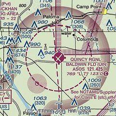
|
CAUTION: Diagram may not be current

| Airport distance calculator |
|---|
|
|
| Sunrise and sunset |
|---|
|
Times for 04-Oct-2025
| | Local
(UTC-5) | | Zulu
(UTC) |
|---|
| Morning civil twilight | | 06:38 | | 11:38 |
| Sunrise | | 07:05 | | 12:05 |
| Sunset | | 18:42 | | 23:42 |
| Evening civil twilight | | 19:09 | | 00:09 |
|
| Current date and time |
|---|
| Zulu (UTC) | 04-Oct-2025 13:34:01 |
|---|
| Local (UTC-5) | 04-Oct-2025 08:34:01 |
|---|
|
| METAR |
|---|
| KUIN | 041254Z AUTO 19005KT 10SM CLR 19/14 A3014 RMK AO2 SLP201 T01890144 $
|
KHAE
17nm SW | 041315Z AUTO 19007KT 10SM CLR 20/14 A3017 RMK AO2
|
KI63
18nm E | 041315Z AUTO 18005KT 10SM CLR 18/15 A3016 RMK AO2 T01790153
|
|
| TAF |
|---|
| KUIN | 041120Z 0412/0512 20008KT P6SM SKC FM041500 19010G20KT P6SM FEW080 FM050000 17008KT P6SM SKC
|
|
| NOTAMs |
|---|
NOTAMs are issued by the DoD/FAA and will open in a separate window not controlled by AirNav.
|
|


