FAA INFORMATION EFFECTIVE 09 JULY 2026
Location
| FAA Identifier: | K52 |
| Lat/Long: | 39-38-03.8790N 091-43-37.1800W
39-38.064650N 091-43.619667W
39.6344108,-91.7269944
(estimated) |
| Elevation: | 737.1 ft. / 224.7 m (surveyed) |
| Variation: | 01E (2000) |
| From city: | 1 mile S of MONROE CITY, MO |
| Time zone: | UTC -5 (UTC -6 during Standard Time) |
| Zip code: | 63456 |
Airport Operations
| Airport use: | Open to the public |
| Control tower: | no |
| ARTCC: | KANSAS CITY CENTER |
| FSS: | SAINT LOUIS FLIGHT SERVICE STATION |
| NOTAMs facility: | STL (NOTAM-D service available) |
| Attendance: | MON-FRI 0800-1700, ALL SAT 0800-1200 |
| Pattern altitude: | 1702.1 ft. MSL
TPA LIGHT ACFT 800 FT AGL, TURBO PROP AND JETS 1500 FT AGL |
| Wind indicator: | lighted |
| Segmented circle: | yes |
| Lights: | DUSK-DAWN. MIRL RY 09/27 PRESET LOW INTST; TO INCR INTST & ACTVT PAPI RYS 09 & 27 - CTAF. |
| Beacon: | white-green (lighted land airport)
Operates sunset to sunrise. |
Airport Communications
| CTAF/UNICOM: | 122.8 |
| WX AWOS-3PT at HAE (14 nm NE): | 120.775 (573-600-5226) |
- APCH/DEP SVC PRVDD BY KANSAS CITY ARTCC ON FREQS 126.225/317.775 (QUINCY RCAG).
Nearby radio navigation aids
| VOR radial/distance | | VOR name | | Freq | | Var |
|---|
| HLVr025/36.4 | | HALLSVILLE VORTAC | | 114.20 | | 06E |
Airport Services
| Fuel available: | 100LL |
| Parking: | tiedowns |
| Bottled oxygen: | NONE |
| Bulk oxygen: | NONE |
Runway Information
Runway 9/27
| Dimensions: | 3515 x 50 ft. / 1071 x 15 m |
| Surface: | asphalt, in good condition |
| Weight bearing capacity: | |
| Runway edge lights: | medium intensity |
| RUNWAY 9 | | RUNWAY 27 |
| Latitude: | 39-38.074267N | | 39-38.055017N |
| Longitude: | 091-43.993933W | | 091-43.245400W |
| Elevation: | 736.6 ft. | | 734.2 ft. |
| Traffic pattern: | left | | left |
| Runway heading: | 091 magnetic, 092 true | | 271 magnetic, 272 true |
| Markings: | nonprecision, in good condition | | nonprecision, in good condition |
| Visual slope indicator: | 2-light PAPI on left (3.00 degrees glide path) | | 2-light PAPI on left (3.00 degrees glide path) |
| Touchdown point: | yes, no lights | | yes, no lights |
| Obstructions: | 20 ft. pole, 495 ft. from runway, 145 ft. right of centerline, 14:1 slope to clear
+1-4' FENCE 0-200' FM RY END 120'R. | | 21 ft. trees, 425 ft. from runway, 125 ft. right of centerline, 10:1 slope to clear
1-5 FT FENCE 65-200 FT FM RY END & 120 FT R; 1-5 FT FENCE 0-200 FT FM RY END & 125 FT L. |
Airport Ownership and Management from official FAA records
| Ownership: | Publicly-owned |
| Owner: | CITY OF MONROE
109 2ND ST., BOX 67
MONROE CITY, MO 63456
Phone 573-735-4845 |
| Manager: | DELL BUCKMAN
109 2ND ST., BOX 67
MONROE CITY, MO 63456
Phone 573-231-9521
AIRPORT OFFICE PHONE (573) 735-4845. |
Additional Remarks
| - | FOR CD CTC KANSAS CITY ARTCC AT 913-254-8508. |
Instrument Procedures
NOTE: All procedures below are presented as PDF files. If you need a reader for these files, you should download the free Adobe Reader.NOT FOR NAVIGATION. Please procure official charts for flight.
FAA instrument procedures published for use from 09 July 2026 at 0901Z to 06 August 2026 at 0900Z.
IAPs - Instrument Approach Procedures |
|---|
| RNAV (GPS) RWY 09 | |
download (184KB) |
| RNAV (GPS) RWY 27 | |
download (183KB) |
| NOTE: Special Take-Off Minimums/Departure Procedures apply | |
download (425KB) |
Other nearby airports with instrument procedures:
KHAE - Hannibal Regional Airport (14 nm NE)
H19 - Bowling Green Municipal Airport (28 nm SE)
KMYJ - Mexico Memorial Airport (29 nm S)
6M6 - Lewis County Regional Airport (30 nm N)
KUIN - Quincy Regional Airport-Baldwin Field (31 nm NE)
|
|

Road maps at:
MapQuest
Bing
Google
| Aerial photo |
|---|
WARNING: Photo may not be current or correct
 Photo By Del Buckman
Photo taken 04-Oct-2009
Photo By Del Buckman
Photo taken 04-Oct-2009
Do you have a better or more recent aerial photo of Cpt. Ben Smith Airfield/Monroe City that you would like to share? If so, please send us your photo.
|
| Sectional chart |
|---|
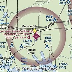
|
| Airport distance calculator |
|---|
|
|
| Sunrise and sunset |
|---|
|
Times for 03-Aug-2026
| | Local
(UTC-5) | | Zulu
(UTC) |
|---|
| Morning civil twilight | | 05:39 | | 10:39 |
| Sunrise | | 06:09 | | 11:09 |
| Sunset | | 20:17 | | 01:17 |
| Evening civil twilight | | 20:47 | | 01:47 |
|
| Current date and time |
|---|
| Zulu (UTC) | 03-Aug-2026 16:54:58 |
|---|
| Local (UTC-5) | 03-Aug-2026 11:54:58 |
|---|
|
| METAR |
|---|
KHAE
14nm NE | 031635Z AUTO 21003KT 10SM SCT027 BKN035 BKN044 27/19 A3002 RMK AO2
|
|
| TAF |
|---|
KUIN
31nm NE | 031120Z 0312/0412 VRB03KT 3SM BR SCT004 TEMPO 0312/0313 1/2SM FG VV004 FM031400 VRB03KT P6SM FEW250 FM040300 12006KT P6SM FEW250
|
|
| NOTAMs |
|---|
NOTAMs are issued by the DoD/FAA and will open in a separate window not controlled by AirNav.
|
|

