FAA INFORMATION EFFECTIVE 20 MARCH 2025
Location
| FAA Identifier: | USW |
| Lat/Long: | 38-49-25.6690N 081-20-55.7840W
38-49.427817N 081-20.929733W
38.8237969,-81.3488289
(estimated) |
| Elevation: | 928.3 ft. / 282.9 m (surveyed) |
| Variation: | 08W (2010) |
| From city: | 1 mile N of SPENCER, WV |
| Time zone: | UTC -4 (UTC -5 during Standard Time) |
| Zip code: | 25276 |
Airport Operations
| Airport use: | Open to the public |
| Activation date: | 03/2001 |
| Control tower: | no |
| ARTCC: | INDIANAPOLIS CENTER |
| FSS: | ELKINS FLIGHT SERVICE STATION [703-724-4288] |
| NOTAMs facility: | EKN (NOTAM-D service available) |
| Attendance: | MON-FRI 0800-1600 |
| Pattern altitude: | TPA SINGLE/MULTI ENG ACFT 1000 FT, TURBINE/LARGE ACFT 1500 FT. |
| Wind indicator: | lighted |
| Segmented circle: | no |
| Lights: | ACTVT MIRL RWY 10/28 - CTAF. |
| Beacon: | white-green (lighted land airport)
ACTVT ROTG BCN - CTAF. |
Airport Communications
| CTAF/UNICOM: | 122.725 |
| WX AWOS-3: | 118.575 (304-927-0123) |
| CHARLESTON APPROACH: | 124.1 |
| CHARLESTON DEPARTURE: | 124.1 |
Nearby radio navigation aids
| VOR radial/distance | | VOR name | | Freq | | Var |
|---|
| HVQr038/34.6 | | CHARLESTON VOR/DME | | 117.40 | | 03W |
| JPUr181/37.1 | | PARKERSBURG VOR/DME | | 114.45 | | 03W |
Airport Services
| Fuel available: | 100LL JET-A
100LL:24 HR SELF SERVICE CREDIT CARD FUEL . |
| Parking: | hangars and tiedowns |
| Airframe service: | MINOR |
| Powerplant service: | MINOR |
Runway Information
Runway 10/28
| Dimensions: | 4549 x 75 ft. / 1387 x 23 m |
| Surface: | asphalt, in good condition |
| Runway edge lights: | medium intensity |
| Runway edge markings: | PVMNT MKG FADED. |
| RUNWAY 10 | | RUNWAY 28 |
| Latitude: | 38-49.442003N | | 38-49.413595N |
| Longitude: | 081-21.408338W | | 081-20.451127W |
| Elevation: | 927.6 ft. | | 927.5 ft. |
| Traffic pattern: | left | | left |
| Runway heading: | 100 magnetic, 092 true | | 280 magnetic, 272 true |
| Markings: | precision, in poor condition | | precision, in poor condition |
| Runway end identifier lights: | no | | no |
| Touchdown point: | yes, no lights | | yes, no lights |
| Obstructions: | 72 ft. trees, 1425 ft. from runway, 400 ft. left of centerline, 17:1 slope to clear
10 FT BRUSH, 30 FT DSTC. | | 160 ft. gnd, 4200 ft. from runway, 25:1 slope to clear
10 FT BRUSH, 30 FT DSTC. |
Airport Ownership and Management from official FAA records
| Ownership: | Privately-owned |
| Owner: | BOGGS AVIATION, LLC
217 AIRFIELD ROAD
SPENCER, WV 25276
Phone 304-927-4045 |
| Manager: | RICHARD C. BOGGS
P.O. BOX 1001
SPENCER, WV 25276
Phone 304-481-1214
ARPT PHYSICAL ADDRESS 217 AIRFIELD RD., SPENCER, WV 25726. |
Additional Remarks
| - | WILDLIFE & DEER ON & INVOF RWY. |
| - | NSTD RWY SAFETY AREA, 50 FT HILL, 170 FT FROM EACH SIDE OF RWY CL. |
| - | OCNL RC MODEL ACFT OPS ON RWY MIDFIELD. |
| - | FOR CD CTC CHARLESTON APCH AT 304-344-5867 EXT 281. |
Instrument Procedures
NOTE: All procedures below are presented as PDF files. If you need a reader for these files, you should download the free Adobe Reader.NOT FOR NAVIGATION. Please procure official charts for flight.
FAA instrument procedures published for use from 20 March 2025 at 0901Z to 17 April 2025 at 0900z.
IAPs - Instrument Approach Procedures |
|---|
| RNAV (GPS) RWY 10 | |
download (240KB) |
| RNAV (GPS) RWY 28 | |
download (239KB) |
| NOTE: Special Take-Off Minimums/Departure Procedures apply | |
download (428KB) |
Other nearby airports with instrument procedures:
I18 - Jackson County Airport (23 nm W)
KCRW - West Virginia International Yeager Airport (29 nm SW)
KPKB - Mid-Ohio Valley Regional Airport (32 nm N)
48I - Braxton County Airport (34 nm E)
3I2 - Mason County Airport (35 nm W)
|
|

Road maps at:
MapQuest
Bing
Google
| Aerial photo |
|---|
WARNING: Photo may not be current or correct
 Photo taken 19-Sep-2009
Do you have a better or more recent aerial photo of Boggs Field Airport that you would like to share? If so, please send us your photo.
|
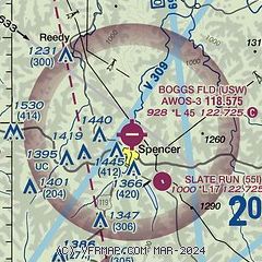
| Sectional chart |
|---|
|
| Airport distance calculator |
|---|
|
|
| Sunrise and sunset |
|---|
|
Times for 09-Apr-2025
| | Local
(UTC-4) | | Zulu
(UTC) |
|---|
| Morning civil twilight | | 06:32 | | 10:32 |
| Sunrise | | 06:59 | | 10:59 |
| Sunset | | 19:55 | | 23:55 |
| Evening civil twilight | | 20:22 | | 00:22 |
|
| Current date and time |
|---|
| Zulu (UTC) | 09-Apr-2025 18:55:24 |
|---|
| Local (UTC-4) | 09-Apr-2025 14:55:24 |
|---|
|
| METAR |
|---|
KCRW
29nm SW | 091754Z VRB05KT 10SM FEW120 FEW240 11/M09 A3019 RMK AO2 SLP225 T01111089 10111 21022 58024
|
KPKB
32nm N | 091753Z VRB03KT 10SM CLR 09/M09 A3021 RMK AO2 SLP235 T00941094 10094 21028 58019
|
K48I
34nm E | 091835Z AUTO VRB05KT 10SM CLR 11/M08 A3017 RMK AO2 T01101079
|
KUNI
47nm NW | 091835Z AUTO 17005KT 10SM SCT100 13/M06 A3018 RMK AO2 T01331064 TSNO
|
|
| TAF |
|---|
KCRW
29nm SW | 091720Z 0918/1018 VRB04KT P6SM FEW200 FM100000 VRB04KT P6SM BKN080 FM101300 19007KT P6SM -SHRA OVC050 FM101500 19008G18KT P6SM -SHRA OVC018
|
KPKB
32nm N | 091720Z 0918/1018 VRB03KT P6SM SCT170 FM100000 VRB04KT P6SM BKN050 FM101100 16005KT P6SM -SHRA BKN050 FM101400 19007G18KT P6SM -SHRA BKN026 FM101700 20009G19KT P6SM -SHRA OVC014
|
|
| NOTAMs |
|---|
NOTAMs are issued by the DoD/FAA and will open in a separate window not controlled by AirNav.
|
|


