FAA INFORMATION EFFECTIVE 14 MAY 2026
Location
| FAA Identifier: | VBW |
| Lat/Long: | 38-21-55.1330N 078-57-32.2740W
38-21.918883N 078-57.537900W
38.3653147,-78.9589650
(estimated) |
| Elevation: | 1165 ft. / 355 m (estimated) |
| Variation: | 09W (2010) |
| From city: | 1 mile SE of BRIDGEWATER, VA |
| Time zone: | UTC -4 (UTC -5 during Standard Time) |
| Zip code: | 22812 |
Airport Operations
| Airport use: | Open to the public |
| Activation date: | 09/1947 |
| Control tower: | no |
| ARTCC: | WASHINGTON CENTER |
| FSS: | LEESBURG FLIGHT SERVICE STATION |
| NOTAMs facility: | DCA (NOTAM-D service available) |
| Attendance: | MON-FRI 0800-1700, ALL SAT 0900-1600, ALL SUN 1200-1600 |
| Wind indicator: | yes |
| Segmented circle: | no |
| Lights: | ACTVT MIRL RWY 15/33 - CTAF. |
| Beacon: | white-green (lighted land airport)
Operates sunset to sunrise. |
Airport Communications
| CTAF/UNICOM: | 122.7 |
| WX AWOS-3: | 119.55 (540-828-2076) |
| POTOMAC APPROACH: | 132.85 |
| POTOMAC DEPARTURE: | 132.85 |
| WX AWOS-3 at SHD (7 nm SE): | 124.925 (540-234-0110) |
| WX AWOS-3PT at W13 (17 nm S): | 118.625 (540-941-7570) |
Nearby radio navigation aids
| VOR radial/distance | | VOR name | | Freq | | Var |
|---|
| MOLr019/28.7 | | MONTEBELLO VOR/DME | | 115.30 | | 05W |
| NDB name | | Hdg/Dist | | Freq | | Var | | ID |
|---|
| STAUT | | 009/9.8 | | 375 | | 09W | | SH | ... .... |
| CAVERNS | | 238/30.4 | | 245 | | 09W | | LUA | .-.. ..- .- |
Airport Services
| Fuel available: | A+ |
| Parking: | tiedowns |
Runway Information
Runway 15/33
| Dimensions: | 4034 x 60 ft. / 1230 x 18 m |
| Surface: | asphalt, in good condition |
| Weight bearing capacity: | |
| Runway edge lights: | medium intensity |
| RUNWAY 15 | | RUNWAY 33 |
| Latitude: | 38-22.183667N | | 38-21.654400N |
| Longitude: | 078-57.793517W | | 078-57.282317W |
| Elevation: | 1156.8 ft. | | 1162.6 ft. |
| Traffic pattern: | left | | left |
| Runway heading: | 152 magnetic, 143 true | | 332 magnetic, 323 true |
| Displaced threshold: | 145 ft. | | no |
| Markings: | nonprecision, in fair condition | | nonprecision, in fair condition |
| Touchdown point: | yes, no lights | | yes, no lights |
| Obstructions: | 11 ft. tree, 298 ft. from runway, 207 ft. right of centerline, 8:1 slope to clear | | 1 ft. fence, 207 ft. from runway, 50 ft. right of centerline, 7:1 slope to clear
RWY 33 2 FT FENCE POST 70 FT FM THR, 27FT R OF CNTRLN. |
Airport Ownership and Management from official FAA records
| Ownership: | Privately-owned |
| Owner: | ROCKINGHAM AVIATION CORP
PO BOX 7
BRIDGEWATER, VA 22812
Phone 540-828-3214 |
| Manager: | AARON LORSON
PO BOX 7
BRIDGEWATER, VA 22812
Phone 540-828-6070 |
Additional Remarks
| - | FOR CD CTC POTOMAC APCH AT 866-640-4124. |
Instrument Procedures
NOTE: All procedures below are presented as PDF files. If you need a reader for these files, you should download the free Adobe Reader.NOT FOR NAVIGATION. Please procure official charts for flight.
FAA instrument procedures published for use from 14 May 2026 at 0901Z to 11 June 2026 at 0900Z.
IAPs - Instrument Approach Procedures |
|---|
| RNAV (GPS) RWY 15 | |
download (218KB) |
| RNAV (GPS) RWY 33 | |
download (198KB) |
| NOTE: Special Alternate Minimums apply | |
download (166KB) |
| NOTE: Special Take-Off Minimums/Departure Procedures apply | |
download (366KB) |
Other nearby airports with instrument procedures:
KSHD - Shenandoah Valley Regional Airport (7 nm SE)
W13 - Eagle's Nest Airport (17 nm S)
8W2 - New Market Airport (21 nm NE)
KCHO - Charlottesville-Albemarle Airport (27 nm SE)
KLUA - Luray Caverns Airport (28 nm NE)
|
|

Road maps at:
MapQuest
Bing
Google
| Aerial photo |
|---|
WARNING: Photo may not be current or correct
 Taken in May 2007
Do you have a better or more recent aerial photo of Bridgewater Air Park that you would like to share? If so, please send us your photo.
|
| Sectional chart |
|---|
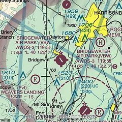
|
| Airport distance calculator |
|---|
|
|
| Sunrise and sunset |
|---|
|
Times for 27-May-2026
| | Local
(UTC-4) | | Zulu
(UTC) |
|---|
| Morning civil twilight | | 05:26 | | 09:26 |
| Sunrise | | 05:57 | | 09:57 |
| Sunset | | 20:29 | | 00:29 |
| Evening civil twilight | | 21:00 | | 01:00 |
|
| Current date and time |
|---|
| Zulu (UTC) | 27-May-2026 16:43:33 |
|---|
| Local (UTC-4) | 27-May-2026 12:43:33 |
|---|
|
| METAR |
|---|
| KVBW | 271615Z AUTO 16007KT 10SM SCT034 BKN046 BKN060 A2999 RMK AO1
|
KSHD
7nm SE | 271615Z AUTO 23006KT 10SM SCT050 SCT085 26/20 A3002 RMK AO2 LTG DSNT E T02550198
|
KW13
17nm S | 271615Z AUTO 23005KT 10SM SCT025 SCT120 26/20 A3003 RMK AO1 T02550196
|
|
| TAF |
|---|
KCHO
28nm SE | 271345Z 2714/2812 21006KT P6SM SCT004 BKN120 FM271800 23006KT 6SM -SHRA SCT035 BKN080 PROB30 2718/2722 3SM TSRA BKN020CB FM280000 31003KT P6SM FEW050 BKN090
|
|
| NOTAMs |
|---|
NOTAMs are issued by the DoD/FAA and will open in a separate window not controlled by AirNav.
|
|

