FAA INFORMATION EFFECTIVE 20 MARCH 2025
Location
| FAA Identifier: | VYS |
| Lat/Long: | 41-21-00.5000N 089-09-10.6000W
41-21.008333N 089-09.176667W
41.3501389,-89.1529444
(estimated) |
| Elevation: | 654.2 ft. / 199.4 m (surveyed) |
| Variation: | 03W (2015) |
| From city: | 1 mile E of PERU, IL |
| Time zone: | UTC -5 (UTC -6 during Standard Time) |
| Zip code: | 61354 |
Airport Operations
| Airport use: | Open to the public |
| Activation date: | 11/1985 |
| Control tower: | no |
| ARTCC: | CHICAGO CENTER |
| FSS: | KANKAKEE FLIGHT SERVICE STATION |
| NOTAMs facility: | VYS (NOTAM-D service available) |
| Attendance: | NOV-FEB MON-FRI 0700-1700, MAR-OCT MON-FRI 0700-1700, ALL SAT-SUN 0800-1600 |
| Wind indicator: | lighted |
| Segmented circle: | yes |
| Lights: | MIRL RY 18/36 PRESET LOW INTST; TO INCR INTST & ACTVT REIL RY 07/25; MIRL RY 07/25; ODALS RY 36; MIRL RY 18/36 - CTAF. |
| Beacon: | white-green (lighted land airport)
Operates sunset to sunrise. |
Airport Communications
| CTAF/UNICOM: | 123.0 |
| WX AWOS-3: | 120.025 (815-223-8442) |
- APCH/DEP SVC PRVDD BY CHICAGO ARTCC (ZAU) ON FREQS 123.75/259.1 (MAZON RCAG).
Nearby radio navigation aids
| VOR radial/distance | | VOR name | | Freq | | Var |
|---|
| BDFr060/22.7 | | BRADFORD VORTAC | | 114.70 | | 00E |
| JOTr251/39.3 | | JOLIET VOR/DME | | 112.30 | | 02E |
Airport Services
| Fuel available: | 100LL JET-A+ |
| Parking: | hangars and tiedowns |
| Airframe service: | MAJOR |
| Powerplant service: | MAJOR |
| Bottled oxygen: | HIGH |
| Bulk oxygen: | HIGH |
Runway Information
Runway 18/36
| Dimensions: | 5999 x 100 ft. / 1828 x 30 m |
| Surface: | asphalt, in good condition |
| Weight bearing capacity: | | Single wheel: | 24.0 | | Double wheel: | 70.0 |
|
| Runway edge lights: | medium intensity |
| RUNWAY 18 | | RUNWAY 36 |
| Latitude: | 41-21.605293N | | 41-20.617465N |
| Longitude: | 089-09.190297W | | 089-09.180550W |
| Elevation: | 654.2 ft. | | 637.5 ft. |
| Traffic pattern: | left | | left |
| Runway heading: | 183 magnetic, 180 true | | 003 magnetic, 360 true |
| Markings: | nonprecision, in good condition | | nonprecision, in good condition |
| Approach lights: | | | ODALS: omnidirectional approach lighting system |
| Touchdown point: | yes, no lights | | yes, no lights |
| Instrument approach: | | | LOCALIZER |
Runway 7/25
| Dimensions: | 3999 x 75 ft. / 1219 x 23 m |
| Surface: | asphalt, in good condition |
| Weight bearing capacity: | |
| Runway edge lights: | medium intensity |
| RUNWAY 7 | | RUNWAY 25 |
| Latitude: | 41-20.763407N | | 41-20.946748N |
| Longitude: | 089-09.583143W | | 089-08.743792W |
| Elevation: | 651.0 ft. | | 649.8 ft. |
| Traffic pattern: | left | | left |
| Runway heading: | 077 magnetic, 074 true | | 257 magnetic, 254 true |
| Markings: | nonprecision, in good condition | | nonprecision, in good condition |
| Runway end identifier lights: | yes | | yes |
| Touchdown point: | yes, no lights | | yes, no lights |
Airport Ownership and Management from official FAA records
| Ownership: | Publicly-owned |
| Owner: | CITY OF PERU
1727 4TH STREET
PERU, IL 61354
Phone 815-223-2003 |
| Manager: | CODY WILLIAMS
ILLINOIS VALLEY RGNL ARPT
PERU, IL 61354
Phone 815-223-2003 |
Additional Remarks
| A52-18 | WIRES AT SOUTH END OF RY ARE NOT THE CTLG OBSTN; APCH SLOPE IS 36:1 & MKD WITH ORANGE BALLS . |
| - | FBO 815-223-2003. |
| - | FOR CD CTC CHICAGO ARTCC AT 630-906-8921. |
Instrument Procedures
NOTE: All procedures below are presented as PDF files. If you need a reader for these files, you should download the free Adobe Reader.NOT FOR NAVIGATION. Please procure official charts for flight.
FAA instrument procedures published for use from 20 March 2025 at 0901Z to 17 April 2025 at 0900z.
IAPs - Instrument Approach Procedures |
|---|
| RNAV (GPS) RWY 18 | |
download (240KB) |
| RNAV (GPS) RWY 36 | |
download (237KB) |
| NOTE: Special Alternate Minimums apply | |
download (140KB) |
| NOTE: Special Take-Off Minimums/Departure Procedures apply | |
download (478KB) |
Other nearby airports with instrument procedures:
C75 - Marshall County Airport (22 nm SW)
C73 - Dixon Municipal Airport-Charles R. Walgreen Field (32 nm NW)
KRPJ - Rochelle Municipal Airport/Koritz Field (33 nm N)
KSQI - Whiteside County Airport/Jos H Bittorf Field (33 nm NW)
C09 - Morris Municipal Airport/James R Washburn Field (33 nm E)
|
|

Road maps at:
MapQuest
Bing
Google
| Aerial photo |
|---|
WARNING: Photo may not be current or correct
 Photo by Jeff Spanier
Photo taken 01-Nov-2011
looking east.
Photo by Jeff Spanier
Photo taken 01-Nov-2011
looking east.
Do you have a better or more recent aerial photo of Illinois Valley Regional Airport-Walter A Duncan Field that you would like to share? If so, please send us your photo.
|
| Sectional chart |
|---|
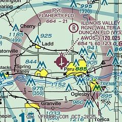
|
| Airport distance calculator |
|---|
|
|
| Sunrise and sunset |
|---|
|
Times for 06-Apr-2025
| | Local
(UTC-5) | | Zulu
(UTC) |
|---|
| Morning civil twilight | | 06:04 | | 11:04 |
| Sunrise | | 06:32 | | 11:32 |
| Sunset | | 19:26 | | 00:26 |
| Evening civil twilight | | 19:54 | | 00:54 |
|
| Current date and time |
|---|
| Zulu (UTC) | 06-Apr-2025 09:55:57 |
|---|
| Local (UTC-5) | 06-Apr-2025 04:55:57 |
|---|
|
| METAR |
|---|
| KVYS | 060935Z AUTO 35006KT 10SM CLR 02/M04 A3013 RMK AO2 T00181042
|
|
| TAF |
|---|
KPIA
48nm SW | 060520Z 0606/0706 01009KT P6SM BKN120 FM062100 VRB04KT P6SM BKN180 FM070400 22006KT P6SM SCT250
|
|
| NOTAMs |
|---|
NOTAMs are issued by the DoD/FAA and will open in a separate window not controlled by AirNav.
|
|


