FAA INFORMATION EFFECTIVE 09 JULY 2026
Location
| FAA Identifier: | W03 |
| Lat/Long: | 35-46-13.4650N 077-58-11.2490W
35-46.224417N 077-58.187483W
35.7704069,-77.9697914
(estimated) |
| Elevation: | 159.6 ft. / 48.6 m (surveyed) |
| Variation: | 08W (1985) |
| From city: | 3 miles N of WILSON, NC |
| Time zone: | UTC -4 (UTC -5 during Standard Time) |
| Zip code: | 27896 |
Airport Operations
| Airport use: | Open to the public |
| Activation date: | 05/1943 |
| Control tower: | no |
| ARTCC: | WASHINGTON CENTER |
| FSS: | RALEIGH FLIGHT SERVICE STATION |
| NOTAMs facility: | RDU (NOTAM-D service available) |
| Attendance: | 0800-1800
UNATNDD THANKSGIVING AND CHRISTMAS DAY. FOR SVC AFT HRS CALL 252-361-0663.
FOR SVC AFT HRS CALL 252-292-8443. |
| Wind indicator: | lighted |
| Segmented circle: | no |
| Lights: | ACTVT REIL RWY 03/21; MIRL RWY 03/21 - CTAF. |
| Beacon: | white-green (lighted land airport)
Operates sunset to sunrise. |
Airport Communications
| CTAF/UNICOM: | 123.0 |
| WX ASOS at RWI (6 nm NE): | 118.875 (252-446-0732) |
| WX AWOS-3P at GWW (19 nm S): | 118.975 (919-731-4473) |
- COMMUNICATIONS PRVDD BY RALEIGH RADIO ON FREQ 122.2 (ROCKY MOUNT RCO)
- APCH/DEP SVC PRVDD BY WASHINGTON ARTCC (ZDC) ON 123.85/279.65 (NEW BERN RCAG).
Nearby radio navigation aids
| VOR radial/distance | | VOR name | | Freq | | Var |
|---|
| TYIr231/17.9 | | TAR RIVER VORTAC | | 117.80 | | 05W |
| ISOr325/31.3 | | KINSTON VORTAC | | 117.50 | | 05W |
| NDB name | | Hdg/Dist | | Freq | | Var | | ID |
|---|
| ALWOOD | | 286/29.4 | | 230 | | 09W | | AQE | .- --.- . |
Airport Services
| Fuel available: | 100LL JET-A1+ |
| Parking: | hangars and tiedowns |
| Airframe service: | NONE |
| Powerplant service: | NONE |
| Bottled oxygen: | NONE |
| Bulk oxygen: | NONE |
Runway Information
Runway 3/21
| Dimensions: | 4500 x 150 ft. / 1372 x 46 m |
| Surface: | asphalt, in good condition |
| Weight bearing capacity: | |
| Runway edge lights: | medium intensity |
| RUNWAY 3 | | RUNWAY 21 |
| Latitude: | 35-45.834330N | | 35-46.473320N |
| Longitude: | 077-58.272787W | | 077-57.810670W |
| Elevation: | 155.5 ft. | | 154.8 ft. |
| Traffic pattern: | left | | left |
| Runway heading: | 039 magnetic, 031 true | | 219 magnetic, 211 true |
| Markings: | nonprecision, in fair condition | | nonprecision, in fair condition |
| Runway end identifier lights: | yes
RWY 03/21 OTS INDEF. | | yes |
| Touchdown point: | yes, no lights | | yes, no lights |
| Obstructions: | 15 ft. trees, 522 ft. from runway, 212 ft. left of centerline, 21:1 slope to clear | | 13 ft. trees, 271 ft. from runway, 117 ft. right of centerline, 5:1 slope to clear |
Runway 15/33
| Dimensions: | 4499 x 150 ft. / 1371 x 46 m |
| Surface: | asphalt, in fair condition
L & T AND BLOCK CRACKING, FOD, FAILED SEALANT. |
| Weight bearing capacity: | |
| Runway edge markings: | DUE TO LINE UNDER RWY NR AND LCTN FM END. |
| RUNWAY 15 | | RUNWAY 33 |
| Latitude: | 35-46.435865N | | 35-45.790620N |
| Longitude: | 077-58.589882W | | 077-58.141593W |
| Elevation: | 159.6 ft. | | 150.9 ft. |
| Traffic pattern: | left | | left |
| Runway heading: | 158 magnetic, 150 true | | 338 magnetic, 330 true |
| Markings: | NSTD, in fair condition | | numbers only, in fair condition |
| Touchdown point: | yes, no lights | | yes, no lights |
| Obstructions: | 34 ft. trees, 362 ft. from runway, 201 ft. right of centerline, 4:1 slope to clear
DUE TO 32 FT TREES 0-200 FT FM END AND OFFSET 169 FT LEFT OF CNTRLN. | | 44 ft. trees, 328 ft. from runway, 209 ft. right of centerline, 2:1 slope to clear
DUE TO 20 FT BLDG 5 FT FM END AND OFFSET 243 FT RIGHT OF CNTRLN. |
Runway 9/27
| Dimensions: | 4498 x 150 ft. / 1371 x 46 m |
| Surface: | asphalt, in poor condition
ROUGH SFC DUE TO EXCESSIVE CRACK SEALANT. |
| Weight bearing capacity: | |
| Runway edge markings: | DUE TO LINE UNDER RWY NR AND LCTN FM END. |
| RUNWAY 9 | | RUNWAY 27 |
| Latitude: | 35-46.407550N | | 35-46.401213N |
| Longitude: | 077-58.610245W | | 077-57.700495W |
| Elevation: | 158.6 ft. | | 154.8 ft. |
| Traffic pattern: | left | | left |
| Runway heading: | 098 magnetic, 090 true | | 278 magnetic, 270 true |
| Markings: | NSTD, in good condition | | numbers only, in good condition |
| Touchdown point: | yes, no lights | | yes, no lights |
| Obstructions: | 38 ft. trees, 530 ft. from runway, 57 ft. left of centerline, 8:1 slope to clear
DUE TO 28 FT TREES 0-200 FT FM END AND OFFSET 136 FT RIGHT OF CNTRLN. | | 43 ft. trees, 464 ft. from runway, 130 ft. right of centerline, 6:1 slope to clear |
Airport Ownership and Management from official FAA records
| Ownership: | Publicly-owned |
| Owner: | CITY OF WILSON
PO BOX 10
WILSON, NC 27894
Phone 252-399-2489 |
| Manager: | GRONNA JONES
PO BOX 10
WILSON, NC 27894
Phone 252-399-2489
ARPT PHONE NR 252-991-6336. |
Additional Remarks
| - | NO LINE-OF-SIGHT BTN RWY ENDS. |
| - | DEER ON & INVOF ARPT. |
| - | FOR CD CTC WASHINGTON ARTCC AT 703-771-3587. |
Instrument Procedures
NOTE: All procedures below are presented as PDF files. If you need a reader for these files, you should download the free Adobe Reader.NOT FOR NAVIGATION. Please procure official charts for flight.
FAA instrument procedures published for use from 09 July 2026 at 0901Z to 06 August 2026 at 0900Z.
IAPs - Instrument Approach Procedures |
|---|
| RNAV (GPS) RWY 03 **CHANGED** | |
download (242KB) |
| RNAV (GPS) RWY 09 **CHANGED** | |
download (215KB) |
| RNAV (GPS) RWY 15 **CHANGED** | |
download (190KB) |
| RNAV (GPS) RWY 21 **CHANGED** | |
download (207KB) |
| RNAV (GPS) RWY 33 **CHANGED** | |
download (208KB) |
| NOTE: Special Take-Off Minimums/Departure Procedures apply | |
download (141KB) |
Other nearby airports with instrument procedures:
KRWI - Rocky Mount/Wilson Regional Airport (6 nm NE)
KGWW - Wayne Executive Jetport Airport (19 nm S)
KETC - Tarboro-Edgecombe Airport (23 nm NE)
KLHZ - Triangle North Executive Airport (23 nm NW)
KJNX - Johnston Regional Airport (25 nm SW)
|
|

Road maps at:
MapQuest
Bing
Google
| Aerial photo |
|---|
WARNING: Photo may not be current or correct
 Photo by Garry Hodges
Photo taken 21-Sep-2010
looking east.
Photo by Garry Hodges
Photo taken 21-Sep-2010
looking east.
Do you have a better or more recent aerial photo of Wilson Industrial Air Center Airport that you would like to share? If so, please send us your photo.
|
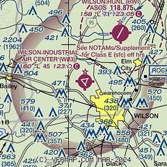
| Sectional chart |
|---|
|
| Airport distance calculator |
|---|
|
|
| Sunrise and sunset |
|---|
|
Times for 16-Jul-2026
| | Local
(UTC-4) | | Zulu
(UTC) |
|---|
| Morning civil twilight | | 05:40 | | 09:40 |
| Sunrise | | 06:09 | | 10:09 |
| Sunset | | 20:27 | | 00:27 |
| Evening civil twilight | | 20:56 | | 00:56 |
|
| Current date and time |
|---|
| Zulu (UTC) | 16-Jul-2026 18:53:12 |
|---|
| Local (UTC-4) | 16-Jul-2026 14:53:12 |
|---|
|
| METAR |
|---|
KRWI
6nm NE | 161753Z AUTO 00000KT 10SM CLR 34/21 A2998 RMK AO2 SLP151 T03390206 10339 20233 58006
|
KGWW
18nm S | 161835Z AUTO 19003KT 10SM CLR 35/22 A2998 RMK AO2 T03450219
|
|
| TAF |
|---|
KRWI
6nm NE | 161720Z 1618/1718 20005KT P6SM SCT060 SCT250
|
|
| NOTAMs |
|---|
NOTAMs are issued by the DoD/FAA and will open in a separate window not controlled by AirNav.
|
|

