FAA INFORMATION EFFECTIVE 16 APRIL 2026
Location
| FAA Identifier: | JNX |
| Lat/Long: | 35-32-27.3770N 078-23-25.1720W
35-32.456283N 078-23.419533W
35.5409381,-78.3903256
(estimated) |
| Elevation: | 164 ft. / 50.0 m (surveyed) |
| Variation: | 09W (2000) |
| From city: | 3 miles NW of SMITHFIELD, NC |
| Time zone: | UTC -4 (UTC -5 during Standard Time) |
| Zip code: | 27577 |
Airport Operations
| Airport use: | Open to the public |
| Activation date: | 06/1978 |
| Control tower: | no |
| ARTCC: | WASHINGTON CENTER |
| FSS: | RALEIGH FLIGHT SERVICE STATION |
| NOTAMs facility: | JNX (NOTAM-D service available) |
| Attendance: | 0800-1800
UNATNDD THANKSGIVING AND CHRISTMAS DAY. |
| Pattern altitude: | 1199 ft. MSL |
| Wind indicator: | lighted |
| Segmented circle: | yes |
| Lights: | ACTVT MALSR RWY 03; REIL RWY 21; MIRL 03/21; TWY LGTS - CTAF. PAPI RWY 03 & 21 OPER CONSLY. |
| Beacon: | white-green (lighted land airport)
Operates sunset to sunrise. |
Airport Communications
| CTAF/UNICOM: | 122.725 |
| WX AWOS-3: | 120.225 (919-934-3851) |
| RALEIGH APPROACH: | 125.3 |
| RALEIGH DEPARTURE: | 125.3 |
| WX AWOS-3 at HRJ (19 nm SW): | 119.025 (910-814-3946) |
Nearby radio navigation aids
| VOR radial/distance | | VOR name | | Freq | | Var |
|---|
| RDUr145/27.6 | | RALEIGH/DURHAM VORTAC | | 117.20 | | 09W |
| NDB name | | Hdg/Dist | | Freq | | Var | | ID |
|---|
| JURLY | | 032/4.3 | | 263 | | 09W | | JN | .--- -. |
| CLINTON | | 007/34.0 | | 412 | | 09W | | CTZ | -.-. - --.. |
Airport Services
| Fuel available: | 100LL JET-A1+ |
| Parking: | tiedowns |
| Airframe service: | MAJOR |
| Powerplant service: | MAJOR |
| Bottled oxygen: | NONE |
| Bulk oxygen: | NONE |
Runway Information
Runway 3/21
| Dimensions: | 5500 x 100 ft. / 1676 x 30 m
HAS A 150 FT SWY ON BOTH ENDS. |
| Surface: | asphalt, in good condition |
| Weight bearing capacity: | | Single wheel: | 65.0 | | Double wheel: | 65.0 |
|
| Runway edge lights: | medium intensity |
| RUNWAY 3 | | RUNWAY 21 |
| Latitude: | 35-32.040413N | | 35-32.872132N |
| Longitude: | 078-23.640188W | | 078-23.198850W |
| Elevation: | 146.9 ft. | | 164.0 ft. |
| Traffic pattern: | left | | left |
| Runway heading: | 032 magnetic, 023 true | | 212 magnetic, 203 true |
| Markings: | precision, in good condition | | nonprecision, in good condition |
| Visual slope indicator: | 4-light PAPI on left (3.00 degrees glide path) | | 4-light PAPI on left (4.00 degrees glide path) |
| Approach lights: | MALSR: 1,400 foot medium intensity approach lighting system with runway alignment indicator lights | | |
| Runway end identifier lights: | | | yes |
| Touchdown point: | yes, no lights | | yes, no lights |
| Instrument approach: | ILS/DME | | |
| Obstructions: | 49 ft. trees, 1167 ft. from runway, 304 ft. right of centerline, 19:1 slope to clear
29 FT TREES 0-200 FT FROM THLD OFFSET 425 FT LEFT OF CNTRLN. | | 36 ft. trees, 241 ft. from runway, 435 ft. left of centerline, 1:1 slope to clear
6 FT GROUND 0-200 FT FR THR OFFSET 301 FT LEFT OF CNTRLN, AND 54 FT TRESS 122 FT FR THR OFFSET 442 FT LEFT OF CNTRLN. |
Airport Ownership and Management from official FAA records
| Ownership: | Publicly-owned |
| Owner: | JOHNSTON CO ARPT AUTH
3149 SWIFT CREEK RD
SMITHFIELD, NC 27577-9803
Phone 919-934-0992 |
| Manager: | DAVID HARRIS
3149 SWIFT CREEK RD
SMITHFIELD, NC 27577-9803
Phone 919-934-0992 |
Additional Remarks
| - | AVOID OVERFLIGHTS OF HOUSING AREA IN TFC PAT FOR NOISE ABATEMENT. FLY WIDER DNWNDS & LONGER DEP LEGS. |
| - | GCO AVBL ON FREQ 135.075 THRU RDU CD & FLT SVCS. |
| - | BE ALERT WHEN TAXING NEAR SOUTH RAMP/CORPORATE HNGR. |
| - | KEY CODE ACES TO PILOT LOUNGE AT PILOT/CREW RAMP. |
| - | HEL FLT T OPS INVOF ARPT. |
| - | GPU AVBL. |
| - | FOR CD IF RALEIGH APCH UNA VIA GCO CTC RALEIGH APCH AT 919-380-3144. |
| - | DEER AND COYOTE ON & INVOF ARPT. |
| - | RWY 21 HAS +65 FT UNMKD PLINE 2000 FT FM THR LEFT AND RIGHT OF CNTRLN. |
| - | 50 FT AGL TWR 200 FT SW OF RWY 03 CNTRLN. |
Instrument Procedures
NOTE: All procedures below are presented as PDF files. If you need a reader for these files, you should download the free Adobe Reader.NOT FOR NAVIGATION. Please procure official charts for flight.
FAA instrument procedures published for use from 16 April 2026 at 0901Z to 14 May 2026 at 0900Z.
IAPs - Instrument Approach Procedures |
|---|
| ILS Y OR LOC Y RWY 03 **CHANGED** | |
download (238KB) |
| ILS Z OR LOC Z RWY 03 **CHANGED** | |
download (291KB) |
| RNAV (GPS) RWY 03 **CHANGED** | |
download (229KB) |
| RNAV (GPS) RWY 21 **CHANGED** | |
download (241KB) |
| NOTE: Special Alternate Minimums apply | |
download |
| NOTE: Special Take-Off Minimums/Departure Procedures apply | |
download |
Other nearby airports with instrument procedures:
KHRJ - Harnett Regional Jetport Airport (19 nm SW)
KGWW - Wayne Executive Jetport Airport (21 nm E)
KGSB - Seymour Johnson Air Force Base (24 nm SE)
W03 - Wilson Industrial Air Center Airport (25 nm NE)
W40 - Mount Olive Municipal Airport (26 nm SE)
|
|

Road maps at:
MapQuest
Bing
Google
| Aerial photo |
|---|
WARNING: Photo may not be current or correct
 Photo courtesy of SkySite Aerial Photography, Ltd.
www.skysiteaerial.com
Photo taken 06-Jun-2006
Do you have a better or more recent aerial photo of Johnston Regional Airport that you would like to share? If so, please send us your photo.
|
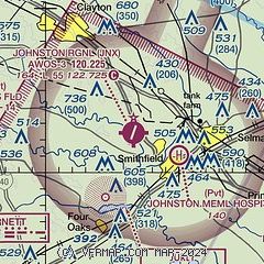
| Sectional chart |
|---|
|
CAUTION: Diagram may not be current

| Airport distance calculator |
|---|
|
|
| Sunrise and sunset |
|---|
|
Times for 07-May-2026
| | Local
(UTC-4) | | Zulu
(UTC) |
|---|
| Morning civil twilight | | 05:49 | | 09:49 |
| Sunrise | | 06:17 | | 10:17 |
| Sunset | | 20:04 | | 00:04 |
| Evening civil twilight | | 20:31 | | 00:31 |
|
| Current date and time |
|---|
| Zulu (UTC) | 07-May-2026 10:21:19 |
|---|
| Local (UTC-4) | 07-May-2026 06:21:19 |
|---|
|
| METAR |
|---|
| KJNX | 070955Z AUTO 23004KT 7SM -RA BKN120 19/19 A2982 RMK AO2 P0008
|
KHRJ
19nm SW | 070955Z AUTO 29004KT 7SM RA BR BKN004 BKN019 OVC035 19/19 A2985 RMK AO2 P0006 T01930188
|
|
| TAF |
|---|
KGSB
25nm SE | 070300Z 0703/0721 21012G18KT 9999 BKN030 BKN250 WS020/24040KT QNH2970INS TEMPO 0703/0705 22010G20KT 6000 -TSRA BKN008CB OVC030 BECMG 0720/0721 32009KT 6000 BR VCSH BKN010 OVC040 QNH2972INS TX29/0619Z TN18/0711Z LAST NO AMDS AFT 0703 NEXT 0709
|
KRDU
27nm NW | 070539Z 0706/0806 20009KT P6SM SCT035 BKN080 TEMPO 0706/0710 4SM -SHRA SCT015 OVC035 FM071000 23009KT 4SM -SHRA BKN025 FM071200 28004KT 3SM -SHRA BR OVC007 FM071500 02010G16KT 5SM -SHRA BR OVC009 FM071900 03010KT P6SM SCT007 OVC015 FM080400 35005KT P6SM SCT015 BKN100
|
KRWI
30nm NE | 070539Z 0706/0806 21008KT P6SM SCT035 BKN080 TEMPO 0706/0710 4SM -SHRA SCT015 OVC040 FM071000 23009KT 4SM -SHRA BKN025 FM071200 28004KT 3SM -SHRA BR OVC012 FM071500 02010KT 5SM -SHRA BR OVC012
|
|
| NOTAMs |
|---|
NOTAMs are issued by the DoD/FAA and will open in a separate window not controlled by AirNav.
|
|


