FAA INFORMATION EFFECTIVE 09 JULY 2026
Location
| FAA Identifier: | W31 |
| Lat/Long: | 36-57-37.4500N 078-11-06.4000W
36-57.624167N 078-11.106667W
36.9604028,-78.1851111
(estimated) |
| Elevation: | 526 ft. / 160.3 m (surveyed) |
| Variation: | 10W (2010) |
| From city: | 3 miles W of KENBRIDGE, VA |
| Time zone: | UTC -4 (UTC -5 during Standard Time) |
| Zip code: | 23974 |
Airport Operations
| Airport use: | Open to the public |
| Activation date: | 01/1964 |
| Control tower: | no |
| ARTCC: | WASHINGTON CENTER |
| FSS: | LEESBURG FLIGHT SERVICE STATION |
| NOTAMs facility: | DCA (NOTAM-D service available) |
| Attendance: | UNATNDD |
| Wind indicator: | lighted |
| Segmented circle: | no |
| Lights: | SS-SR |
| Beacon: | white-green (lighted land airport)
Operates sunset to sunrise. |
Airport Communications
| CTAF/UNICOM: | 122.7 |
| WX AWOS-3: | 123.875 (434-676-1078) |
| WX ASOS at BKT (13 nm NE): | PHONE 434-292-1400 |
| WX AWOS-3 at W81 (14 nm N): | 119.050 |
| WX AWOS-3 at AVC (17 nm S): | 127.525 (434-729-2229) |
| WX AWOS-3 at CXE (18 nm SW): | 121.225 (434-372-4506) |
- APCH/DEP SVC PRVDD BY WASHINGTON ARTCC ON FREQS 118.75/377.10 (GREEN BAY RCAG).
Nearby radio navigation aids
| VOR radial/distance | | VOR name | | Freq | | Var |
|---|
| FAKr213/38.1 | | FLAT ROCK VORTAC | | 113.30 | | 06W |
| NDB name | | Hdg/Dist | | Freq | | Var | | ID |
|---|
| BLACKSTONE | | 223/12.1 | | 326 | | 09W | | BKT | -... -.- - |
Airport Services
| Fuel available: | 100LL
100LL:FUEL AVBL DALGT HRS, CTC AMGR. |
| Parking: | tiedowns |
| Airframe service: | NONE |
| Powerplant service: | NONE |
| Bottled oxygen: | NONE |
| Bulk oxygen: | NONE |
Runway Information
Runway 2/20
| Dimensions: | 3000 x 50 ft. / 914 x 15 m |
| Surface: | asphalt, in excellent condition |
| Weight bearing capacity: | |
| Runway edge lights: | low intensity |
| RUNWAY 2 | | RUNWAY 20 |
| Latitude: | 36-57.383333N | | 36-57.865000N |
| Longitude: | 078-11.176667W | | 078-11.036667W |
| Elevation: | 512.0 ft. | | 525.0 ft. |
| Traffic pattern: | left | | left |
| Runway heading: | 023 magnetic, 013 true | | 203 magnetic, 193 true |
| Markings: | basic, in good condition | | basic, in good condition |
| Visual slope indicator: | panels that may or may not be lighted, on left (5.00 degrees glide path) | | panels that may or may not be lighted, on left (5.00 degrees glide path) |
| Touchdown point: | yes, no lights | | yes, no lights |
| Obstructions: | 37 ft. tree, 318 ft. from runway, 231 ft. right of centerline, 3:1 slope to clear | | 53 ft. tree, 283 ft. from runway, 176 ft. right of centerline, 1:1 slope to clear
TREE AT 195 FT FM RWY END, 216 FT RIGHT ON APCH. |
Airport Ownership and Management from official FAA records
| Ownership: | Publicly-owned |
| Owner: | LUNENBURG COUNTY
11409 COURTHOUSE RD, ATTN: COUNTY ADMINISTRATOR
LUNENBURG, VA 23952
Phone 434-696-2142 |
| Manager: | LARRY WAY
634 AIRPORT ROAD
VICTORIA, VA 23974
Phone 434-262-3750 |
Additional Remarks
| - | DEER ON AND INVOF ARPT. |
| - | FOR CD CTC WASHINGTON ARTCC AT 703-771-3587. |
Instrument Procedures
NOTE: All procedures below are presented as PDF files. If you need a reader for these files, you should download the free Adobe Reader.NOT FOR NAVIGATION. Please procure official charts for flight.
FAA instrument procedures published for use from 09 July 2026 at 0901Z to 06 August 2026 at 0900Z.
IAPs - Instrument Approach Procedures |
|---|
| RNAV (GPS)-A | |
download (177KB) |
| RNAV (GPS)-B | |
download (171KB) |
| NOTE: Special Alternate Minimums apply | |
download (78KB) |
| NOTE: Special Take-Off Minimums/Departure Procedures apply | |
download (140KB) |
Other nearby airports with instrument procedures:
KBKT - Allan C Perkinson/Blackstone AAF Airport (13 nm NE)
W81 - Crewe Municipal Airport (14 nm N)
KAVC - Mecklenburg-Brunswick Regional Airport (17 nm S)
KCXE - Chase City Municipal Airport (18 nm SW)
KLVL - Brunswick County Airport (22 nm SE)
|
|

Road maps at:
MapQuest
Bing
Google
| Aerial photo |
|---|
WARNING: Photo may not be current or correct
 Photo taken 16-Sep-2019
looking northwest.
Photo taken 16-Sep-2019
looking northwest.
Do you have a better or more recent aerial photo of Lunenburg County Airport that you would like to share? If so, please send us your photo.
|
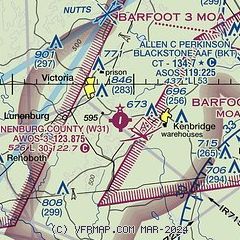
| Sectional chart |
|---|
|
| Airport distance calculator |
|---|
|
|
| Sunrise and sunset |
|---|
|
Times for 29-Jul-2026
| | Local
(UTC-4) | | Zulu
(UTC) |
|---|
| Morning civil twilight | | 05:48 | | 09:48 |
| Sunrise | | 06:17 | | 10:17 |
| Sunset | | 20:22 | | 00:22 |
| Evening civil twilight | | 20:51 | | 00:51 |
|
| Current date and time |
|---|
| Zulu (UTC) | 29-Jul-2026 07:12:25 |
|---|
| Local (UTC-4) | 29-Jul-2026 03:12:25 |
|---|
|
| METAR |
|---|
| KW31 | 290655Z AUTO 32003KT 10SM CLR 24/23 A2966 RMK AO1 T02370226
|
KBKT
13nm NE | 290555Z AUTO 33005KT 10SM FEW049 SCT055 24/23 A2963 RMK AO2 SLP032 T02440232 10274 20244 52008 $
|
KW81
14nm N | 290655Z AUTO 00000KT 10SM CLR 22/20 A2965 RMK AO1 T02170197
|
KAVC
18nm SE | 290655Z AUTO 00000KT 10SM CLR 23/22 A2970 RMK AO2 T02280222
|
KCXE
18nm SW | 290655Z AUTO 00000KT 10SM CLR 22/22 A2966 RMK AO1 T02190215
|
|
| NOTAMs |
|---|
NOTAMs are issued by the DoD/FAA and will open in a separate window not controlled by AirNav.
|
|

