FAA INFORMATION EFFECTIVE 25 DECEMBER 2025
Location
| FAA Identifier: | AVC |
| Lat/Long: | 36-41-17.8000N 078-03-16.1000W
36-41.296667N 078-03.268333W
36.6882778,-78.0544722
(estimated) |
| Elevation: | 441.4 ft. / 134.5 m (surveyed) |
| Variation: | 09W (2000) |
| From city: | 4 miles SE of SOUTH HILL, VA |
| Time zone: | UTC -5 (UTC -4 during Daylight Saving Time) |
| Zip code: | 23950 |
Airport Operations
| Airport use: | Open to the public |
| Activation date: | 09/1974 |
| Control tower: | no |
| ARTCC: | WASHINGTON CENTER |
| FSS: | LEESBURG FLIGHT SERVICE STATION |
| NOTAMs facility: | AVC (NOTAM-D service available) |
| Attendance: | 0800-1700
ARPT CLSD ON FED HOLS. |
| Pattern altitude: | 1841.4 ft. MSL |
| Wind indicator: | lighted |
| Segmented circle: | yes |
| Lights: | ACTIVATE REIL RY 01/19; MIRL RY 01/19 PRESET LOW INTST; FOR HIGHER INTST & TO ACTVT ODALS - CTAF. |
| Beacon: | white-green (lighted land airport)
Operates sunset to sunrise. |
Airport Communications
| CTAF/UNICOM: | 122.8 |
| WX AWOS-3: | 127.525 (434-729-2229) |
| WX AWOS-3 at LVL (14 nm E): | 119.625 (434-848-2017) |
| WX AWOS-3 at W31 (17 nm N): | 123.875 (434-676-1078) |
- APCH/DEP SVC PRVDD BY WASHINGTON ARTCC ON FREQS 118.75/377.1 (GREEN BAY RCAG).
Nearby radio navigation aids
| NDB name | | Hdg/Dist | | Freq | | Var | | ID |
|---|
| BLACKSTONE | | 190/26.4 | | 326 | | 09W | | BKT | -... -.- - |
| HUNTSBORO | | 059/35.8 | | 271 | | 09W | | HXO | .... -..- --- |
Airport Services
| Fuel available: | 100LL JET-A
100LL:24 HR FUEL AVBL BY CREDIT CARD. |
| Parking: | tiedowns |
| Airframe service: | MINOR |
| Powerplant service: | MINOR |
| Bottled oxygen: | NONE |
| Bulk oxygen: | NONE |
Runway Information
Runway 1/19
| Dimensions: | 5002 x 75 ft. / 1525 x 23 m |
| Surface: | asphalt, in good condition |
| Weight bearing capacity: | |
| Runway edge lights: | medium intensity |
| RUNWAY 1 | | RUNWAY 19 |
| Latitude: | 36-40.885488N | | 36-41.708980N |
| Longitude: | 078-03.246613W | | 078-03.289460W |
| Elevation: | 377.6 ft. | | 441.4 ft. |
| Traffic pattern: | left | | left |
| Runway heading: | 007 magnetic, 358 true | | 187 magnetic, 178 true |
| Markings: | nonprecision, in good condition | | nonprecision, in good condition |
| Visual slope indicator: | 2-light PAPI on left (3.00 degrees glide path) | | 2-light PAPI on left (3.00 degrees glide path) |
| Approach lights: | ODALS: omnidirectional approach lighting system | | |
| Runway end identifier lights: | yes | | yes |
| Touchdown point: | yes, no lights | | yes, no lights |
| Instrument approach: | LOC/DME | | |
| Obstructions: | 84 ft. tree, 3069 ft. from runway, 530 ft. right of centerline, 34:1 slope to clear | | 17 ft. trees, 308 ft. from runway, 258 ft. right of centerline, 6:1 slope to clear |
Airport Ownership and Management from official FAA records
| Ownership: | Publicly-owned |
| Owner: | MECKLENBURG-BRUNSWICK RGNL APT COMM
1495 REGIONAL AIRPORT RD
BRODNAX, VA 23920-3520
Phone 434-729-1002 |
| Manager: | JOHN ZUBROD
1495 REGIONAL AIRPORT RD
BRODNAX, VA 23920-3520
Phone 434-774-8023 |
Additional Remarks
| - | DEER & BIRDS ON & INVOF ARPT |
| - | CORPORATE HANGER TAXILANE RESTRICTED TO AIRCRAFT WITH WINGSPAN NO LARGER THAN 55 FT. |
| - | FOR CD CTC WASHINGTON ARTCC AT 703-771-3587. |
Instrument Procedures
NOTE: All procedures below are presented as PDF files. If you need a reader for these files, you should download the free Adobe Reader.NOT FOR NAVIGATION. Please procure official charts for flight.
FAA instrument procedures published for use from 25 December 2025 at 0901z to 22 January 2026 at 0900z.
IAPs - Instrument Approach Procedures |
|---|
| RNAV (GPS) RWY 01 | |
download (273KB) |
| RNAV (GPS) RWY 19 | |
download (222KB) |
| LOC RWY 01 | |
download (281KB) |
| NOTE: Special Alternate Minimums apply | |
download (78KB) |
| NOTE: Special Take-Off Minimums/Departure Procedures apply | |
download (140KB) |
Other nearby airports with instrument procedures:
KLVL - Brunswick County Airport (14 nm NE)
W31 - Lunenburg County Airport (17 nm N)
KCXE - Chase City Municipal Airport (22 nm W)
KBKT - Allan C Perkinson/Blackstone AAF Airport (24 nm N)
W63 - Lake Country Regional Airport (25 nm W)
|
|

Road maps at:
MapQuest
Bing
Google
| Aerial photo |
|---|
WARNING: Photo may not be current or correct

Do you have a better or more recent aerial photo of Mecklenburg-Brunswick Regional Airport that you would like to share? If so, please send us your photo.
|
| Sectional chart |
|---|
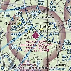
|
| Airport distance calculator |
|---|
|
|
| Sunrise and sunset |
|---|
|
Times for 11-Jan-2026
| | Local
(UTC-5) | | Zulu
(UTC) |
|---|
| Morning civil twilight | | 06:57 | | 11:57 |
| Sunrise | | 07:26 | | 12:26 |
| Sunset | | 17:15 | | 22:15 |
| Evening civil twilight | | 17:43 | | 22:43 |
|
| Current date and time |
|---|
| Zulu (UTC) | 12-Jan-2026 01:40:58 |
|---|
| Local (UTC-5) | 11-Jan-2026 20:40:58 |
|---|
|
| METAR |
|---|
| KAVC | 120115Z AUTO 28005KT 10SM CLR 02/M09 A3030 RMK AO2 T00231095
|
KLVL
14nm E | 120115Z AUTO 30003KT 10SM CLR 03/M11 A3025 RMK AO1 T00261109
|
KW31
17nm N | 120115Z AUTO 24003KT 10SM CLR 02/M09 A3023 RMK AO1 T00181095
|
|
| NOTAMs |
|---|
NOTAMs are issued by the DoD/FAA and will open in a separate window not controlled by AirNav.
|
|

