FAA INFORMATION EFFECTIVE 16 APRIL 2026
Location
| FAA Identifier: | CXE |
| Lat/Long: | 36-47-18.0080N 078-30-05.5930W
36-47.300133N 078-30.093217W
36.7883356,-78.5015536
(estimated) |
| Elevation: | 503 ft. / 153.3 m (surveyed) |
| Variation: | 09W (2005) |
| From city: | 2 miles W of CHASE CITY, VA |
| Time zone: | UTC -4 (UTC -5 during Standard Time) |
| Zip code: | 23924 |
Airport Operations
| Airport use: | Open to the public |
| Activation date: | 09/1952 |
| Control tower: | no |
| ARTCC: | WASHINGTON CENTER |
| FSS: | LEESBURG FLIGHT SERVICE STATION |
| NOTAMs facility: | DCA (NOTAM-D service available) |
| Attendance: | UNATTENDED |
| Pattern altitude: | 1303 ft. MSL |
| Wind indicator: | yes |
| Segmented circle: | no |
Airport Communications
| CTAF: | 122.9 |
| WX AWOS-3: | 121.225 (434-372-4506) |
| WX AWOS-3 at W63 (12 nm S): | 118.225 (434-374-2431) |
| WX AWOS-3 at W78 (17 nm W): | 119.425 (434-575-0332) |
| WX AWOS-3 at W31 (18 nm NE): | 123.875 (434-676-1078) |
- APCH/DEP SVC PRVDD BY WASHINGTON ARTCC ON FREQS 118.75/377.1 (GREEN BAY RCAG).
Nearby radio navigation aids
| VOR radial/distance | | VOR name | | Freq | | Var |
|---|
| SBVr080/25.6 | | SOUTH BOSTON VORTAC | | 110.40 | | 05W |
| NDB name | | Hdg/Dist | | Freq | | Var | | ID |
|---|
| HUNTSBORO | | 020/29.8 | | 271 | | 09W | | HXO | .... -..- --- |
| BLACKSTONE | | 236/29.9 | | 326 | | 09W | | BKT | -... -.- - |
Airport Services
| Parking: | tiedowns |
| Bottled oxygen: | NONE |
| Bulk oxygen: | NONE |
Runway Information
Runway 18/36
| Dimensions: | 3400 x 50 ft. / 1036 x 15 m |
| Surface: | asphalt, in poor condition
SEVERE RWY CRACKING. 1-2 INCHES IN PLACES AND ALG CNTRLN.
LONGITUDINAL AND TRANSVERSE CRACKING. SOME RAVELING IN CERTAIN AREAS. |
| Weight bearing capacity: | |
| Runway edge markings: | MARKINGS SEVERELY FADED
MARKINGS SEVERELY FADED AND RAVELING. |
| RUNWAY 18 | | RUNWAY 36 |
| Latitude: | 36-47.578267N | | 36-47.020417N |
| Longitude: | 078-30.125467W | | 078-30.060167W |
| Elevation: | 503.0 ft. | | 486.0 ft. |
| Traffic pattern: | left | | left |
| Runway heading: | 184 magnetic, 175 true | | 004 magnetic, 355 true |
| Markings: | nonprecision, in poor condition | | nonprecision, in poor condition |
| Touchdown point: | yes, no lights | | yes, no lights |
| Obstructions: | 23 ft. road, 200 ft. from runway, 108 ft. right of centerline
+6 FT GND 115 FT R OF RWY END; +20 FT ROAD 100 FT FM THR, 125 FT R. | | 31 ft. brush, 247 ft. from runway, 115 ft. right of centerline, 1:1 slope to clear
RISING GND 150 FT FM RWY END; 30 FT TREES 100 FT BOTH SIDES OF CNTRLN. |
Airport Ownership and Management from official FAA records
| Ownership: | Publicly-owned |
| Owner: | TOWN OF CHASE CITY
319 N MAIN ST
CHASE CITY, VA 23924
Phone 434-372-5136 |
| Manager: | CHARLES FORBES
319 N MAIN ST
CHASE CITY, VA 23924
Phone 434-372-5136
TOWN MANAGER. |
Additional Remarks
| - | DEER ON & INVOF ARPT. |
| - | FARM EQUIP OPERATING NEAR RWY. |
| - | ARPT CLSD SS-SR INDEFLY. |
| - | FOR CD CTC WASHINGTON ARTCC AT 703-771-3587. |
Instrument Procedures
NOTE: All procedures below are presented as PDF files. If you need a reader for these files, you should download the free Adobe Reader.NOT FOR NAVIGATION. Please procure official charts for flight.
FAA instrument procedures published for use from 16 April 2026 at 0901Z to 14 May 2026 at 0900Z.
IAPs - Instrument Approach Procedures |
|---|
| RNAV (GPS) RWY 18 | |
download (176KB) |
| RNAV (GPS) RWY 36 | |
download (187KB) |
| NOTE: Special Alternate Minimums apply | |
download (167KB) |
| NOTE: Special Take-Off Minimums/Departure Procedures apply | |
download (140KB) |
Other nearby airports with instrument procedures:
W63 - Lake Country Regional Airport (12 nm S)
W78 - William M Tuck Airport (17 nm W)
W31 - Lunenburg County Airport (18 nm NE)
KAVC - Mecklenburg-Brunswick Regional Airport (22 nm E)
KHNZ - Henderson/Oxford Airport (26 nm S)
|
|

Road maps at:
MapQuest
Bing
Google
| Aerial photo |
|---|
WARNING: Photo may not be current or correct
 Photo taken 16-Sep-2019
looking north.
Photo taken 16-Sep-2019
looking north.
Do you have a better or more recent aerial photo of Chase City Municipal Airport that you would like to share? If so, please send us your photo.
|
| Sectional chart |
|---|
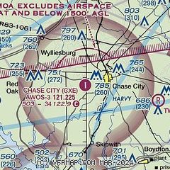
|
| Airport distance calculator |
|---|
|
|
| Sunrise and sunset |
|---|
|
Times for 08-May-2026
| | Local
(UTC-4) | | Zulu
(UTC) |
|---|
| Morning civil twilight | | 05:45 | | 09:45 |
| Sunrise | | 06:14 | | 10:14 |
| Sunset | | 20:07 | | 00:07 |
| Evening civil twilight | | 20:36 | | 00:36 |
|
| Current date and time |
|---|
| Zulu (UTC) | 08-May-2026 06:08:27 |
|---|
| Local (UTC-4) | 08-May-2026 02:08:27 |
|---|
|
| METAR |
|---|
| KCXE | 080555Z AUTO 00000KT 1SM OVC002 09/08 A2994 RMK AO1 T00850082 10112 20080
|
KW63
12nm S | 080555Z AUTO 00000KT 1/4SM OVC002 A2994 RMK AO1
|
KW78
17nm W | 080555Z AUTO 00000KT 1/4SM OVC002 08/07 A2995 RMK AO1 T00750068 10123 20061
|
KW31
18nm NE | 080555Z AUTO 25003KT 7SM CLR 08/08 A2993 RMK AO1 T00810081 10116 20069
|
|
| TAF |
|---|
KDAN
42nm W | 080520Z 0806/0906 00000KT 1/2SM FG VV001 FM081300 VRB04KT P6SM SKC
|
KLYH
46nm NW | 080426Z 0804/0824 00000KT 1/2SM FG VV001 FM080900 20004KT P6SM SKC
|
|
| NOTAMs |
|---|
NOTAMs are issued by the DoD/FAA and will open in a separate window not controlled by AirNav.
|
|

