FAA INFORMATION EFFECTIVE 09 JULY 2026
Location
| FAA Identifier: | W78 |
| Lat/Long: | 36-42-33.7407N 078-50-54.0149W
36-42.562345N 078-50.900248W
36.7093724,-78.8483375
(estimated) |
| Elevation: | 419.8 ft. / 128.0 m (surveyed) |
| Variation: | 08W (1995) |
| From city: | 3 miles E of SOUTH BOSTON, VA |
| Time zone: | UTC -4 (UTC -5 during Standard Time) |
| Zip code: | 24592 |
Airport Operations
| Airport use: | Open to the public |
| Activation date: | 09/1949 |
| Control tower: | no |
| ARTCC: | WASHINGTON CENTER |
| FSS: | LEESBURG FLIGHT SERVICE STATION |
| NOTAMs facility: | DCA (NOTAM-D service available) |
| Attendance: | UNATTENDED |
| Pattern altitude: | 1219.8 ft. MSL |
| Wind indicator: | lighted |
| Segmented circle: | no |
| Lights: | ACTVT MIRL RY 01/19 & REIL RYS 01 & 19 - CTAF. PAPI RYS 01 & 19 OPER CONT. |
| Beacon: | white-green (lighted land airport)
Operates sunset to sunrise. |
Airport Communications
| CTAF/UNICOM: | 122.8 |
| WX AWOS-3: | 119.425 (434-575-0332) |
| WX AWOS-3 at W63 (15 nm SE): | 118.225 (434-374-2431) |
| WX AWOS-3 at CXE (17 nm E): | 121.225 (434-372-4506) |
- COMMUNICATIONS PRVDD BY LEESBURG RADIO ON FREQS 122.1R/110.4T (SOUTH BOSTON RCO).
- APCH/DEP SVC PRVDD BY WASHINGTON ARTCC ON FREQS 124.05/352.0 (SOUTH BOSTON RCAG).
Nearby radio navigation aids
| VOR radial/distance | | VOR name | | Freq | | Var |
|---|
| SBVr081/8.3 | | SOUTH BOSTON VORTAC | | 110.40 | | 05W |
| LYHr155/37.6 | | LYNCHBURG VOR/DME | | 109.20 | | 05W |
| NDB name | | Hdg/Dist | | Freq | | Var | | ID |
|---|
| HUNTSBORO | | 345/26.9 | | 271 | | 09W | | HXO | .... -..- --- |
Airport Services
| Fuel available: | 100LL |
| Parking: | tiedowns |
| Airframe service: | MINOR |
| Powerplant service: | MINOR |
| Bottled oxygen: | NONE |
| Bulk oxygen: | NONE |
Runway Information
Runway 1/19
| Dimensions: | 4003 x 75 ft. / 1220 x 23 m |
| Surface: | asphalt, in good condition |
| Weight bearing capacity: | |
| Runway edge lights: | medium intensity |
| RUNWAY 1 | | RUNWAY 19 |
| Latitude: | 36-42.272418N | | 36-42.930965N |
| Longitude: | 078-50.857067W | | 078-50.904865W |
| Elevation: | 382.5 ft. | | 419.8 ft. |
| Traffic pattern: | left | | left |
| Runway heading: | 005 magnetic, 357 true | | 185 magnetic, 177 true |
| Markings: | nonprecision, in good condition | | nonprecision, in good condition |
| Visual slope indicator: | 2-light PAPI on left (3.00 degrees glide path) | | 2-light PAPI on left (3.00 degrees glide path) |
| Runway end identifier lights: | yes | | yes |
| Touchdown point: | yes, no lights | | yes, no lights |
| Obstructions: | 28 ft. trees, 481 ft. from runway, 265 ft. left of centerline, 10:1 slope to clear
5 FT BRUSH 150 FT LEFT AND RIGHT OF RWY CNTRLN. | | 42 ft. tree, 861 ft. from runway, 100 ft. right of centerline, 15:1 slope to clear |
Runway 6/24
| Dimensions: | 2065 x 200 ft. / 629 x 61 m |
| Surface: | turf, in good condition |
| Runway edge markings: | RY 24 OUTLINED WITH YELLOW CONES. |
| RUNWAY 6 | | RUNWAY 24 |
| Latitude: | 36-42.373102N | | 36-42.599038N |
| Longitude: | 078-51.095602W | | 078-50.779653W |
| Elevation: | 375.6 ft. | | 389.8 ft. |
| Traffic pattern: | left | | left |
| Runway heading: | 056 magnetic, 048 true | | 236 magnetic, 228 true |
| Touchdown point: | yes, no lights | | yes, no lights |
| Obstructions: | 69 ft. trees, 1134 ft. from runway, 143 ft. right of centerline, 13:1 slope to clear | | 70 ft. trees, 891 ft. from runway, 70 ft. right of centerline, 9:1 slope to clear |
Airport Ownership and Management from official FAA records
| Ownership: | Publicly-owned |
| Owner: | COUNTY OF HALIFAX
PO BOX 699
HALIFAX, VA 24558
Phone 434-476-3300 |
| Manager: | JASON JOHNSON
PO BOX 699
HALIFAX, VA 24558
Phone 434-476-3300 |
Additional Remarks
| - | WILDLIFE ON & INVOF RYS. |
| - | SELF-FUELING WITH A CREDIT CARD. |
| - | RWY 06/24 CLSD TO ACFT WITH AIRSPEED 50 KT OR MORE. |
| - | FOR CD CTC WASHINGTON ARTCC AT 703-771-3587. |
Instrument Procedures
NOTE: All procedures below are presented as PDF files. If you need a reader for these files, you should download the free Adobe Reader.NOT FOR NAVIGATION. Please procure official charts for flight.
FAA instrument procedures published for use from 09 July 2026 at 0901Z to 06 August 2026 at 0900Z.
IAPs - Instrument Approach Procedures |
|---|
| RNAV (GPS) RWY 01 | |
download (258KB) |
| VOR-A | |
download (211KB) |
| NOTE: Special Alternate Minimums apply | |
download (41KB) |
| NOTE: Special Take-Off Minimums/Departure Procedures apply | |
download (359KB) |
Other nearby airports with instrument procedures:
W63 - Lake Country Regional Airport (15 nm SE)
KCXE - Chase City Municipal Airport (17 nm E)
KDAN - Danville Regional Airport (25 nm W)
KHNZ - Henderson/Oxford Airport (26 nm SE)
KTDF - Raleigh Regional Airport at Person County (26 nm S)
|
|

Road maps at:
MapQuest
Bing
Google
| Aerial photo |
|---|
WARNING: Photo may not be current or correct
 Photo by Kenton Good
Taken in August 2017
looking south.
Photo by Kenton Good
Taken in August 2017
looking south.
Do you have a better or more recent aerial photo of William M Tuck Airport that you would like to share? If so, please send us your photo.
|
| Sectional chart |
|---|
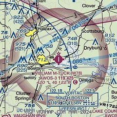
|
| Airport distance calculator |
|---|
|
|
| Sunrise and sunset |
|---|
|
Times for 03-Aug-2026
| | Local
(UTC-4) | | Zulu
(UTC) |
|---|
| Morning civil twilight | | 05:55 | | 09:55 |
| Sunrise | | 06:24 | | 10:24 |
| Sunset | | 20:19 | | 00:19 |
| Evening civil twilight | | 20:48 | | 00:48 |
|
| Current date and time |
|---|
| Zulu (UTC) | 03-Aug-2026 13:31:40 |
|---|
| Local (UTC-4) | 03-Aug-2026 09:31:40 |
|---|
|
| METAR |
|---|
| KW78 | 031315Z AUTO 20003KT 10SM BKN012 OVC017 24/22 A2986 RMK AO1 T02410217
|
KW63
15nm SE | 031315Z AUTO 21004KT 10SM OVC018 24/22 A2986 RMK AO1
|
KCXE
17nm E | 031315Z AUTO 21003KT 10SM SCT011 OVC017 24/23 A2986 RMK AO1 T02420232
|
|
| TAF |
|---|
KDAN
25nm W | 031120Z 0312/0412 22004KT P6SM BKN015 FM031900 24004KT P6SM VCTS BKN035 BKN070CB FM040100 03005KT P6SM BKN070
|
|
| NOTAMs |
|---|
NOTAMs are issued by the DoD/FAA and will open in a separate window not controlled by AirNav.
|
|

