FAA INFORMATION EFFECTIVE 14 MAY 2026
Location
| FAA Identifier: | HNZ |
| Lat/Long: | 36-21-40.1070N 078-31-47.3780W
36-21.668450N 078-31.789633W
36.3611408,-78.5298272
(estimated) |
| Elevation: | 526.3 ft. / 160.4 m (surveyed) |
| Variation: | 09W (2015) |
| From city: | 4 miles NE of OXFORD, NC |
| Time zone: | UTC -4 (UTC -5 during Standard Time) |
| Zip code: | 27565 |
Airport Operations
| Airport use: | Open to the public |
| Activation date: | 09/1971 |
| Control tower: | no |
| ARTCC: | WASHINGTON CENTER |
| FSS: | RALEIGH FLIGHT SERVICE STATION |
| NOTAMs facility: | HNZ (NOTAM-D service available) |
| Attendance: | MON-SAT 0800-1700, ALL SUN 1300-1700
UNATTENDED THANKSGIVING & CHRISTMAS DAYS. |
| Wind indicator: | lighted |
| Segmented circle: | yes |
| Lights: | ACTVT REIL RWY 06; MIRL RWY 06/24 - CTAF. PAPI RWY 06 & 24 OPR CONSLY. |
| Beacon: | white-green (lighted land airport)
Operates sunset to sunrise. |
Airport Communications
| CTAF/UNICOM: | 122.8 |
| WX AWOS-3: | 118.625 (919-693-9516) |
| RALEIGH APPROACH: | 132.35 |
| RALEIGH DEPARTURE: | 132.35 |
| WX AWOS-3 at W63 (14 nm N): | 118.225 (434-374-2431) |
Nearby radio navigation aids
| VOR radial/distance | | VOR name | | Freq | | Var |
|---|
| SBVr134/30.0 | | SOUTH BOSTON VORTAC | | 110.40 | | 05W |
| RDUr032/31.8 | | RALEIGH/DURHAM VORTAC | | 117.20 | | 09W |
| NDB name | | Hdg/Dist | | Freq | | Var | | ID |
|---|
| HUNTSBORO | | 059/5.6 | | 271 | | 09W | | HXO | .... -..- --- |
Airport Services
| Fuel available: | 100LL JET-A1+
100LL:FUEL 24 HR CREDIT CARD SVC AVBL. |
| Parking: | tiedowns |
| Airframe service: | MAJOR |
| Powerplant service: | MAJOR |
| Bottled oxygen: | NONE |
| Bulk oxygen: | NONE |
Runway Information
Runway 6/24
| Dimensions: | 5501 x 100 ft. / 1677 x 30 m |
| Surface: | asphalt/grooved, in good condition |
| Weight bearing capacity: | |
| Runway edge lights: | medium intensity |
| RUNWAY 6 | | RUNWAY 24 |
| Latitude: | 36-21.384428N | | 36-21.952448N |
| Longitude: | 078-32.226343W | | 078-31.352855W |
| Elevation: | 523.2 ft. | | 505.1 ft. |
| Traffic pattern: | left | | left |
| Runway heading: | 060 magnetic, 051 true | | 240 magnetic, 231 true |
| Markings: | nonprecision, in good condition | | nonprecision, in good condition |
| Visual slope indicator: | 4-light PAPI on left (3.25 degrees glide path) | | 4-light PAPI on right (3.00 degrees glide path) |
| Runway end identifier lights: | yes | | |
| Touchdown point: | yes, no lights | | yes, no lights |
| Instrument approach: | LOCALIZER | | |
| Obstructions: | 48 ft. trees, 1634 ft. from runway, 63 ft. left of centerline, 29:1 slope to clear | | 33 ft. pline, 1353 ft. from runway, 34:1 slope to clear |
Airport Ownership and Management from official FAA records
| Ownership: | Publicly-owned |
| Owner: | OXFORD-HENDERSON ARPT AUTH
6514 AIRPORT ROAD
OXFORD, NC 27565-6459
Phone 919-693-5769 |
| Manager: | AMANDA WELSH
6514 AIRPORT ROAD
OXFORD, NC 27565-6459
Phone 919-693-5769 |
Additional Remarks
| - | RWY 24 HAS 60 FT DROP OFF 325 FT FM THR & 90 FT LEFT & RIGHT FM CNTRLN. |
| - | RWY 6 HAS 28 FT UNMARKED POWERLINE 1000 FT FM THR ON CNTRLN. |
| - | NO LINE OF SIGHT BTN RWY ENDS. |
| - | FOR AFTER HOURS SERVICE CALL 919-693-5769. |
| - | TREES EAST OF THE ARPT OBSCURE THE ROTG BCN. |
| - | HOLD LINES ARE LESS THAN 150 FT FROM CNTRLN. |
| - | RWY 24 HAS 30 FT UNMKD POWERLINE 1000 FT FM THR ON CNTRLN. |
| - | FOR CD IF UNA VIA GCO CTC RALEIGH APCH AT 919-380-3144. |
| - | RWY 6 HAS 30 FT DROP-OFF 280 FT FROM THR & 40-60 FT DROP-OFF 75 FT BOTH SIDES OF CNTRLN. |
Instrument Procedures
NOTE: All procedures below are presented as PDF files. If you need a reader for these files, you should download the free Adobe Reader.NOT FOR NAVIGATION. Please procure official charts for flight.
FAA instrument procedures published for use from 14 May 2026 at 0901Z to 11 June 2026 at 0900Z.
IAPs - Instrument Approach Procedures |
|---|
| RNAV (GPS) RWY 06 | |
download (257KB) |
| RNAV (GPS) RWY 24 | |
download (262KB) |
| LOC RWY 06 | |
download (259KB) |
| NOTE: Special Alternate Minimums apply | |
download (142KB) |
| NOTE: Special Take-Off Minimums/Departure Procedures apply | |
download (356KB) |
Other nearby airports with instrument procedures:
W63 - Lake Country Regional Airport (14 nm N)
KLHZ - Triangle North Executive Airport (22 nm SE)
KTDF - Raleigh Regional Airport at Person County (22 nm W)
KCXE - Chase City Municipal Airport (26 nm N)
W78 - William M Tuck Airport (26 nm NW)
|
|

Road maps at:
MapQuest
Bing
Google
| Aerial photo |
|---|
WARNING: Photo may not be current or correct
 Photo by David Strevel, Raleigh NC
Taken in July 2015
looking west.
Photo by David Strevel, Raleigh NC
Taken in July 2015
looking west.
Do you have a better or more recent aerial photo of Henderson/Oxford Airport that you would like to share? If so, please send us your photo.
|
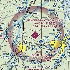
| Sectional chart |
|---|
|
| Airport distance calculator |
|---|
|
|
| Sunrise and sunset |
|---|
|
Times for 18-May-2026
| | Local
(UTC-4) | | Zulu
(UTC) |
|---|
| Morning civil twilight | | 05:37 | | 09:37 |
| Sunrise | | 06:06 | | 10:06 |
| Sunset | | 20:15 | | 00:15 |
| Evening civil twilight | | 20:44 | | 00:44 |
|
| Current date and time |
|---|
| Zulu (UTC) | 18-May-2026 07:13:34 |
|---|
| Local (UTC-4) | 18-May-2026 03:13:34 |
|---|
|
| METAR |
|---|
| KHNZ | 180415Z AUTO 19003KT 10SM CLR 21/15 A3019 RMK AO2 T02070151
|
KW63
14nm N | 180435Z AUTO 20003KT 10SM CLR A3017 RMK AO1
|
|
| TAF |
|---|
KRDU
32nm SW | 180520Z 1806/1906 21006KT P6SM SKC
|
|
| NOTAMs |
|---|
NOTAMs are issued by the DoD/FAA and will open in a separate window not controlled by AirNav.
|
|

