FAA INFORMATION EFFECTIVE 25 DECEMBER 2025
Location
| FAA Identifier: | W63 |
| Lat/Long: | 36-35-46.9200N 078-33-35.0260W
36-35.782000N 078-33.583767W
36.5963667,-78.5597294
(estimated) |
| Elevation: | 420.9 ft. / 128 m (estimated) |
| Variation: | 08W (1995) |
| From city: | 2 miles S of CLARKSVILLE, VA |
| Time zone: | UTC -5 (UTC -4 during Daylight Saving Time) |
| Zip code: | 23927 |
Airport Operations
| Airport use: | Open to the public |
| Activation date: | 03/1961 |
| Control tower: | no |
| ARTCC: | WASHINGTON CENTER |
| FSS: | LEESBURG FLIGHT SERVICE STATION |
| NOTAMs facility: | DCA (NOTAM-D service available) |
| Attendance: | 0800-1700 |
| Pattern altitude: | 1220.9 ft. MSL |
| Wind indicator: | yes |
| Segmented circle: | no |
| Lights: | SS-SR |
| Beacon: | white-green (lighted land airport)
Operates sunset to sunrise. |
Airport Communications
| CTAF: | 122.9 |
| WX AWOS-3: | 118.225 (434-374-2431) |
| WX AWOS-3 at CXE (12 nm N): | 121.225 (434-372-4506) |
| WX AWOS-3 at HNZ (14 nm S): | 118.625 (919-693-9516) |
| WX AWOS-3 at W78 (15 nm NW): | 119.425 (434-575-0332) |
- APCH/DEP SVC PRVDD BY WASHINGTON ARTCC ON FREQS 118.75/377.1 (GREEN BAY RCAG).
Nearby radio navigation aids
| VOR radial/distance | | VOR name | | Freq | | Var |
|---|
| SBVr107/22.4 | | SOUTH BOSTON VORTAC | | 110.40 | | 05W |
| NDB name | | Hdg/Dist | | Freq | | Var | | ID |
|---|
| HUNTSBORO | | 018/17.9 | | 271 | | 09W | | HXO | .... -..- --- |
Airport Services
| Fuel available: | 100LL |
| Parking: | tiedowns |
| Airframe service: | NONE |
| Powerplant service: | NONE |
| Bottled oxygen: | NONE |
| Bulk oxygen: | NONE |
Runway Information
Runway 4/22
| Dimensions: | 4007 x 50 ft. / 1221 x 15 m |
| Surface: | asphalt, in good condition |
| Weight bearing capacity: | |
| Runway edge lights: | medium intensity |
| RUNWAY 4 | | RUNWAY 22 |
| Latitude: | 36-35.489667N | | 36-36.074333N |
| Longitude: | 078-33.774000W | | 078-33.393500W |
| Elevation: | 373.7 ft. | | 411.8 ft. |
| Traffic pattern: | left | | left |
| Runway heading: | 036 magnetic, 028 true | | 216 magnetic, 208 true |
| Displaced threshold: | no | | 480 ft. |
| Markings: | nonprecision, in good condition | | basic, in good condition |
| Touchdown point: | yes, no lights | | yes, no lights |
| Obstructions: | 29 ft. tree, 416 ft. from runway, 279 ft. right of centerline, 7:1 slope to clear
CLOSE-IN OBSTN, 27 FT ABV RWY SFC, ROW OF TREES 179 FT RIGHT OF CNTRLN ON APCH. | | 18 ft. road, 200 ft. from runway, 1:1 slope to clear
ROAD CROSSING 170 FT FROM END OF RWY. BUILDING 27 FT, 90 FT FROM END OF RWY, 110 FT L. |
Airport Ownership and Management from official FAA records
| Ownership: | Publicly-owned |
| Owner: | LAKE COUNTRY REG AIRPORT COMMISSION
LAKE COUNTRY REGIONAL AIRPORT, POST OFFICE BOX 1047
CLARKSVILLE, VA 23927
Phone 434-374-8028 |
| Manager: | MICHAEL DENTON
LAKE COUNTRY REGIONAL AIRPORT, 11632 HWY 15
CLARKSVILLE, VA 23927
Phone 434-374-8028 |
Additional Remarks
| - | WILDLIFE INVOF ARPT. |
| - | SELF SVC FUEL AVBL. |
| - | FOR CD CTC WASHINGTON ARTCC AT 703-771-3587. |
Instrument Procedures
NOTE: All procedures below are presented as PDF files. If you need a reader for these files, you should download the free Adobe Reader.NOT FOR NAVIGATION. Please procure official charts for flight.
FAA instrument procedures published for use from 25 December 2025 at 0901z to 22 January 2026 at 0900z.
IAPs - Instrument Approach Procedures |
|---|
| RNAV (GPS) RWY 04 | |
download (213KB) |
| NOTE: Special Alternate Minimums apply | |
download (169KB) |
| NOTE: Special Take-Off Minimums/Departure Procedures apply | |
download (140KB) |
Other nearby airports with instrument procedures:
KCXE - Chase City Municipal Airport (12 nm N)
KHNZ - Henderson/Oxford Airport (14 nm S)
W78 - William M Tuck Airport (15 nm NW)
KAVC - Mecklenburg-Brunswick Regional Airport (25 nm E)
KTDF - Raleigh Regional Airport at Person County (28 nm SW)
|
|

Road maps at:
MapQuest
Bing
Google
| Aerial photo |
|---|
WARNING: Photo may not be current or correct
 Photo taken 16-Sep-2019
looking south.
Photo taken 16-Sep-2019
looking south.
Do you have a better or more recent aerial photo of Lake Country Regional Airport that you would like to share? If so, please send us your photo.
|
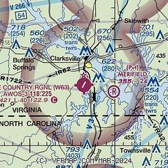
| Sectional chart |
|---|
|
| Airport distance calculator |
|---|
|
|
| Sunrise and sunset |
|---|
|
Times for 13-Jan-2026
| | Local
(UTC-5) | | Zulu
(UTC) |
|---|
| Morning civil twilight | | 06:59 | | 11:59 |
| Sunrise | | 07:27 | | 12:27 |
| Sunset | | 17:19 | | 22:19 |
| Evening civil twilight | | 17:47 | | 22:47 |
|
| Current date and time |
|---|
| Zulu (UTC) | 13-Jan-2026 06:23:16 |
|---|
| Local (UTC-5) | 13-Jan-2026 01:23:16 |
|---|
|
| METAR |
|---|
| KW63 | 130555Z AUTO 22005KT 10SM CLR 01/M06 A3021 RMK AO1
|
KCXE
12nm N | 130555Z AUTO 00000KT 10SM CLR 00/M07 A3021 RMK AO1 T00001066 10017 21015
|
KHNZ
14nm S | 130555Z AUTO 21006KT 10SM CLR M02/M08 A3021 RMK AO2 T10171078 10035 21025 400851055
|
KW78
15nm NW | 130555Z AUTO 22003KT 10SM CLR 00/M07 A3022 RMK AO1 T00041073 10039 21030
|
|
| TAF |
|---|
KDAN
37nm W | 130520Z 1306/1406 20006KT P6SM SKC FM131500 23008G15KT P6SM FEW250
|
KRDU
45nm S | 130522Z 1306/1406 22004KT P6SM SCT250 FM131800 21010G18KT P6SM SCT250
|
|
| NOTAMs |
|---|
NOTAMs are issued by the DoD/FAA and will open in a separate window not controlled by AirNav.
|
|

