FAA INFORMATION EFFECTIVE 16 APRIL 2026
Location
| FAA Identifier: | W35 |
| Lat/Long: | 39-41-33.4000N 078-09-57.9000W
39-41.556667N 078-09.965000W
39.6926111,-78.1660833
(estimated) |
| Elevation: | 412.5 ft. / 125.7 m (surveyed) |
| Variation: | 10W (2000) |
| From city: | 4 miles N of BERKELEY SPRINGS, WV |
| Time zone: | UTC -4 (UTC -5 during Standard Time) |
| Zip code: | 25411 |
Airport Operations
| Airport use: | Open to the public |
| Activation date: | 12/1947 |
| Control tower: | no |
| ARTCC: | WASHINGTON CENTER |
| FSS: | ELKINS FLIGHT SERVICE STATION [703-724-4288] |
| NOTAMs facility: | EKN (NOTAM-D service available) |
| Attendance: | IREG |
| Wind indicator: | yes |
| Segmented circle: | no |
| Lights: | SS-SR |
Airport Communications
| CTAF: | 122.9 |
| POTOMAC APPROACH: | 126.825 |
| POTOMAC DEPARTURE: | 126.825 |
| WX ASOS at MRB (19 nm SE): | 119.925 (304-264-0988) |
Nearby radio navigation aids
| VOR radial/distance | | VOR name | | Freq | | Var |
|---|
| HGRr276/(14.3) | | HAGERSTOWN VOR | | 109.80 | | 07W |
| MRBr328/23.6 | | MARTINSBURG VORTAC | | 112.10 | | 07W |
Airport Services
| Airframe service: | NONE |
| Powerplant service: | NONE |
| Bottled oxygen: | NONE |
| Bulk oxygen: | NONE |
Runway Information
Runway 11/29
| Dimensions: | 4979 x 70 ft. / 1518 x 21 m |
| Surface: | asphalt, in poor condition
PAVEMENT SPALLING, CRACKS, UNEVEN SURFACE. LOOSE AGGREGATE AND STONES. VEGETATION GROWING THROUGH PAVEMENT. |
| Runway edge lights: | medium intensity |
| Runway edge markings: | NO MKGS. |
| RUNWAY 11 | | RUNWAY 29 |
| Latitude: | 39-41.625638N | | 39-41.487682N |
| Longitude: | 078-10.487978W | | 078-09.441572W |
| Elevation: | 409.9 ft. | | 411.5 ft. |
| Traffic pattern: | left | | right |
| Runway heading: | 110 magnetic, 100 true | | 290 magnetic, 280 true |
| Runway end identifier lights: | no | | no |
| Touchdown point: | yes, no lights | | yes, no lights |
| Obstructions: | 60 ft. trees, 201 ft. from runway, 110 ft. right of centerline
60 FT TREES; UP TO 200 FT DSTC, 110 FT LEFT. | | 40 ft. trees, 201 ft. from runway, 110 ft. right of centerline
40 FT TREES; AT THLD, 10 FT RIGHT. |
Airport Ownership and Management from official FAA records
| Ownership: | Privately-owned |
| Owner: | RIVERSIDE AIRPARK, LLC
12107 BOYD RD
CLEAR SPRING, MD 21722-1605
Phone 301-842-3700 |
| Manager: | RIVERSIDE AIRPARK, LLC
12107 BOYD RD
CLEAR SPRING, MD 21722-1605
Phone 301-842-3700 |
Additional Remarks
| - | NO ACFT OVER 18500 LBS GWT. |
| - | FOR CD CTC POTOMAC APCH AT 866-709-4993. |
| - | DRAG RACING ON RWY. EXTSV RUBBER BUILD UP ON RWY 29 PAVEMENT END. |
| - | RWY 29 END, POSSIBILITY OF 12 FT GRANDSTAND ON EACH SIDE OF RWY, 13 FT. FM RWY EDGE. |
| - | 8 FT CROPS, 50-80 FT R/L RWY CL. |
| - | ARPT CLSD NIGHTS. |
| - | UNMANNED ACFT 1000/BLW 1 NMR OF ARPT. |
| - | RC MODEL ACFT OPER ON ARPT. |
| - | AIRPORT ENTRANCE GATE LOCKED. NO PUBLIC ACCESS TO AIRPORT. |
| - | BIRDS & WILDLIFE INVOF ARPT. |
| - | RWY 11 APCH END, 10 FT DROP OFF, 30 FT FROM PAVEMENT END. RWY 29 15 FT DROP OFF, 30 FT FM RWY END. |
Instrument Procedures
NOTE: All procedures below are presented as PDF files. If you need a reader for these files, you should download the free Adobe Reader.NOT FOR NAVIGATION. Please procure official charts for flight.
FAA instrument procedures published for use from 16 April 2026 at 0901Z to 14 May 2026 at 0900Z.
IAPs - Instrument Approach Procedures |
|---|
| RNAV (GPS) RWY 11 | |
download (187KB) |
| RNAV (GPS) RWY 29 | |
download (215KB) |
| NOTE: Special Take-Off Minimums/Departure Procedures apply | |
download (335KB) |
Other nearby airports with instrument procedures:
KMRB - Eastern WV Regional Airport/Shepherd Field (19 nm SE)
KHGR - Hagerstown Regional Airport-Richard A Henson Field (20 nm E)
KCBE - Greater Cumberland Regional Airport (28 nm W)
KHMZ - Bedford County Airport (29 nm NW)
N68 - Franklin County Regional Airport (29 nm NE)
|
|

Road maps at:
MapQuest
Bing
Google
| Aerial photo |
|---|
WARNING: Photo may not be current or correct
 Photo by Rose Kelly
Taken in the Fall of 2007
from a powered parachute
Photo by Rose Kelly
Taken in the Fall of 2007
from a powered parachute
Do you have a better or more recent aerial photo of Potomac Airpark that you would like to share? If so, please send us your photo.
|
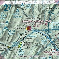
| Sectional chart |
|---|
|
| Airport distance calculator |
|---|
|
|
| Sunrise and sunset |
|---|
|
Times for 18-Apr-2026
| | Local
(UTC-4) | | Zulu
(UTC) |
|---|
| Morning civil twilight | | 06:04 | | 10:04 |
| Sunrise | | 06:32 | | 10:32 |
| Sunset | | 19:52 | | 23:52 |
| Evening civil twilight | | 20:20 | | 00:20 |
|
| Current date and time |
|---|
| Zulu (UTC) | 18-Apr-2026 11:32:34 |
|---|
| Local (UTC-4) | 18-Apr-2026 07:32:34 |
|---|
|
| METAR |
|---|
KMRB
19nm SE | 181053Z AUTO 00000KT 10SM CLR 11/09 A2997 RMK AO2 SLP147 T01060094
|
KHGR
20nm E | 181053Z 00000KT 10SM CLR 14/11 A2997 RMK AO2 SLP156 T01440111
|
KCBE
28nm W | 181115Z AUTO 00000KT 10SM CLR 10/09 A3003 RMK AO2 T01010089
|
KHMZ
29nm NW | 181115Z AUTO 00000KT 10SM CLR 08/07 A2999 RMK AO2 T00760072
|
KOKV
34nm S | 181115Z AUTO 00000KT 10SM CLR 12/09 A2998 RMK AO2
|
KAOO
37nm N | 181053Z AUTO 00000KT 10SM CLR 13/09 A2998 RMK AO2 SLP149 T01280089
|
|
| TAF |
|---|
KMRB
19nm SE | 180526Z 1806/1906 00000KT P6SM FEW050 FEW250 FM180900 10003KT P6SM FEW050 FEW250 FM181400 15007KT P6SM SCT100 FM181700 17010G18KT P6SM SCT200 FM182300 17011G19KT P6SM SCT050 BKN200 PROB30 1823/1824 4SM SHRA FM190400 20006KT P6SM -SHRA SCT027 BKN060
|
|
| NOTAMs |
|---|
NOTAMs are issued by the DoD/FAA and will open in a separate window not controlled by AirNav.
|
|

