FAA INFORMATION EFFECTIVE 14 MAY 2026
Location
| FAA Identifier: | HMZ |
| Lat/Long: | 40-05-10.0500N 078-30-48.5940W
40-05.167500N 078-30.809900W
40.0861250,-78.5134983
(estimated) |
| Elevation: | 1161.7 ft. / 354.1 m (surveyed) |
| Variation: | 09W (1995) |
| From city: | 4 miles N of BEDFORD, PA |
| Time zone: | UTC -4 (UTC -5 during Standard Time) |
| Zip code: | 15522 |
Airport Operations
| Airport use: | Open to the public |
| Activation date: | 03/1994 |
| Control tower: | no |
| ARTCC: | CLEVELAND CENTER |
| FSS: | ALTOONA FLIGHT SERVICE STATION |
| NOTAMs facility: | AOO (NOTAM-D service available) |
| Attendance: | MON-FRI 0800-1630, ALL SAT 0800-1630, ALL SUN 0800-1630
FOR SVC AFTER HRS CNT 814-494-0929 |
| Wind indicator: | lighted |
| Segmented circle: | yes |
| Lights: | ACTVT MIRL RWY 14/32; REIL RWY 14 & 32 - CTAF. PAPI RWY 14 & 32 OPR CONSLY. REIL ACTVT ONLY WITH 3, 5, OR 7 CLICKS. |
| Beacon: | white-green (lighted land airport)
Operates sunset to sunrise. |
| Landing fee: | yes, LANDING FEE FOR ALL ACFT EXCEPT LIGHT SINGLE ENGINE WITH FUEL PURCHASE. |
Airport Communications
| CTAF/UNICOM: | 122.7 |
| WX AWOS-3: | 123.675 (814-623-2936) |
| JOHNSTOWN APPROACH: | 121.2 |
| JOHNSTOWN DEPARTURE: | 121.2 |
| WX ASOS at AOO (15 nm NE): | 127.125 (814-793-9655) |
- APCH/DEP SVC PRVDD BY CLEVELAND ARTCC (ZOB) ON FREQS 124.4/327.1 (ALTOONA RCAG) WHEN JOHNSTOWN APCH CTL CLSD.
Nearby radio navigation aids
| VOR radial/distance | | VOR name | | Freq | | Var |
|---|
| JSTr139/20.2 | | JOHNSTOWN VOR/DME | | 113.00 | | 06W |
| HGRr315/(38.2) | | HAGERSTOWN VOR | | 109.80 | | 07W |
Airport Services
| Fuel available: | 100LL JET-A |
| Parking: | hangars and tiedowns |
| Airframe service: | MAJOR |
| Powerplant service: | MAJOR |
| Bulk oxygen: | HIGH |
Runway Information
Runway 14/32
| Dimensions: | 5006 x 75 ft. / 1526 x 23 m |
| Surface: | asphalt, in good condition |
| Weight bearing capacity: | | Single wheel: | 38.0 | | Double wheel: | 60.0 | | Double tandem: | 100.0 |
|
| Runway edge lights: | medium intensity |
| RUNWAY 14 | | RUNWAY 32 |
| Latitude: | 40-05.418972N | | 40-04.916015N |
| Longitude: | 078-31.235142W | | 078-30.384715W |
| Elevation: | 1156.2 ft. | | 1160.6 ft. |
| Traffic pattern: | right | | left |
| Runway heading: | 137 magnetic, 128 true | | 317 magnetic, 308 true |
| Markings: | nonprecision, in good condition | | nonprecision, in good condition |
| Visual slope indicator: | 2-light PAPI on right (3.00 degrees glide path) | | 2-light PAPI on left (4.00 degrees glide path) |
| Runway end identifier lights: | yes | | yes |
| Touchdown point: | yes, no lights | | yes, no lights |
| Obstructions: | none | | 17 ft. trees, 671 ft. from runway, 284 ft. left of centerline, 27:1 slope to clear |
Airport Ownership and Management from official FAA records
| Ownership: | Publicly-owned |
| Owner: | BEDFORD CO AIRPORT AUTHORITY
227 AIRPORT RD
BEDFORD, PA 15522
Phone 814-623-0704 |
| Manager: | JIM VEACH
227 AIRPORT RD
BEDFORD, PA 15522
Phone 814-623-0704 |
Additional Remarks
| - | HIGH TERRAIN (MTN RIDGES) SOUTHEAST OF ARPT LGTD WITH RED OBSTRUCTION LGTS. |
| - | FOR CD CTC JOHNSTOWN APCH AT 814-532-5960, WHEN APCH CLSD CTC CLEVELAND ARTCC AT 440-774-0213. |
Instrument Procedures
NOTE: All procedures below are presented as PDF files. If you need a reader for these files, you should download the free Adobe Reader.NOT FOR NAVIGATION. Please procure official charts for flight.
FAA instrument procedures published for use from 14 May 2026 at 0901Z to 11 June 2026 at 0900Z.
IAPs - Instrument Approach Procedures |
|---|
| RNAV (GPS) RWY 14 | |
download (226KB) |
| RNAV (GPS) RWY 32 | |
download (257KB) |
| NOTE: Special Alternate Minimums apply | |
download (145KB) |
| NOTE: Special Take-Off Minimums/Departure Procedures apply | |
download (149KB) |
Other nearby airports with instrument procedures:
KAOO - Altoona/Blair County Airport (15 nm NE)
KJST - John Murtha Johnstown/Cambria County Airport (20 nm NW)
2G9 - Somerset County Airport (23 nm W)
9G8 - Ebensburg Airport (26 nm NW)
W35 - Potomac Airpark (29 nm SE)
|
|

Road maps at:
MapQuest
Bing
Google
| Aerial photo |
|---|
WARNING: Photo may not be current or correct
 Photo courtesy of AirNav, LLC
Photo taken 24-Aug-2014
looking northeast.
Photo courtesy of AirNav, LLC
Photo taken 24-Aug-2014
looking northeast.
Do you have a better or more recent aerial photo of Bedford County Airport that you would like to share? If so, please send us your photo.
|
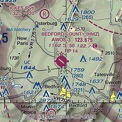
| Sectional chart |
|---|
|
| Airport distance calculator |
|---|
|
|
| Sunrise and sunset |
|---|
|
Times for 24-May-2026
| | Local
(UTC-4) | | Zulu
(UTC) |
|---|
| Morning civil twilight | | 05:21 | | 09:21 |
| Sunrise | | 05:52 | | 09:52 |
| Sunset | | 20:29 | | 00:29 |
| Evening civil twilight | | 21:01 | | 01:01 |
|
| Current date and time |
|---|
| Zulu (UTC) | 24-May-2026 18:43:52 |
|---|
| Local (UTC-4) | 24-May-2026 14:43:52 |
|---|
|
| METAR |
|---|
| KHMZ | 241815Z AUTO 13009KT 10SM OVC011 15/12 A3020 RMK AO2 T01460116
|
KAOO
16nm NE | 241753Z AUTO 16008KT 10SM OVC010 15/12 A3021 RMK AO2 SLP231 T01500122 10150 20089 56015
|
|
| TAF |
|---|
KAOO
16nm NE | 241733Z 2418/2518 13005KT 6SM BR OVC009 FM250100 16004KT 2SM -SHRA BR OVC004 FM250800 20003KT 4SM -SHRA BR OVC003 FM251300 29003KT 6SM BR OVC007 FM251600 35004KT 6SM BR OVC009
|
|
| NOTAMs |
|---|
NOTAMs are issued by the DoD/FAA and will open in a separate window not controlled by AirNav.
|
|


