FAA INFORMATION EFFECTIVE 11 JUNE 2026
Location
| FAA Identifier: | Y23 |
| Lat/Long: | 45-18-23.3552N 091-38-12.5629W
45-18.389253N 091-38.209382W
45.3064876,-91.6368230
(estimated) |
| Elevation: | 1056 ft. / 321.9 m (surveyed) |
| Variation: | 00E (2000) |
| From city: | 1 mile SE of CHETEK, WI |
| Time zone: | UTC -5 (UTC -6 during Standard Time) |
| Zip code: | 54728 |
Airport Operations
| Airport use: | Open to the public |
| Activation date: | 10/1945 |
| Control tower: | no |
| ARTCC: | MINNEAPOLIS CENTER |
| FSS: | GREEN BAY FLIGHT SERVICE STATION |
| NOTAMs facility: | GRB (NOTAM-D service available) |
| Attendance: | UNATNDD |
| Wind indicator: | lighted |
| Segmented circle: | yes |
| Lights: | MIRL RWY 17/35 PRESET ON LOW SS-SR; TO INCR INTST & ACTVT REIL RWY 17 & 35; PAPI RWY 17 & 35; MIRL RWY 17/35 - CTAF. |
| Beacon: | white-green (lighted land airport)
Operates sunset to sunrise. |
Airport Communications
| CTAF: | 122.9 |
| WX AWOS-3P: | 119.05 (715-924-1836) |
| WX AWOS-3 at RPD (9 nm NW): | 120.525 (715-458-4481) |
| WX AWOS-3PT at UBE (19 nm NW): | 119.175 (715-822-3452) |
- APCH/DEP SVC PRVDD BY MINNEAPOLIS ARTCC ON FREQS 125.3/335.6 (EAU CLAIRE RCAG).
Nearby radio navigation aids
| VOR radial/distance | | VOR name | | Freq | | Var |
|---|
| EAUr341/25.4 | | EAU CLAIRE VORTAC | | 113.65 | | 04E |
| NDB name | | Hdg/Dist | | Freq | | Var | | ID |
|---|
| WICKR | | 095/7.0 | | 221 | | 01E | | RP | .-. .--. |
Airport Services
| Fuel available: | 100LL
100LL:24 HR SELF SVC FUEL AVBL WITH CREDIT CARD. |
| Parking: | tiedowns |
| Airframe service: | MINOR |
| Powerplant service: | MINOR |
| Bottled oxygen: | NONE |
| Bulk oxygen: | NONE |
Runway Information
Runway 17/35
| Dimensions: | 3401 x 60 ft. / 1037 x 18 m |
| Surface: | asphalt, in fair condition |
| Runway edge lights: | medium intensity |
| RUNWAY 17 | | RUNWAY 35 |
| Latitude: | 45-18.615215N | | 45-18.057903N |
| Longitude: | 091-38.162717W | | 091-38.089827W |
| Elevation: | 1055.0 ft. | | 1056.0 ft. |
| Traffic pattern: | left | | right |
| Runway heading: | 175 | | 355 |
| Displaced threshold: | 600 ft. | | no |
| Markings: | nonprecision, in good condition | | nonprecision, in good condition |
| Visual slope indicator: | 2-light PAPI on left (4.00 degrees glide path) | | 2-light PAPI on left (3.00 degrees glide path) |
| Runway end identifier lights: | yes | | yes |
| Touchdown point: | yes, no lights | | yes, no lights |
| Obstructions: | 38 ft. tree, lighted, 540 ft. from runway, 165 ft. left of centerline, 8:1 slope to clear
HANGAR 200 FT LEFT. | | 13 ft. road, lighted, 370 ft. from runway, 13:1 slope to clear |
Runway 7/25
| Dimensions: | 1490 x 120 ft. / 454 x 37 m |
| Surface: | turf, in fair condition |
| Runway edge markings: | MKD WITH YELLOW CONES. |
| RUNWAY 7 | | RUNWAY 25 |
| Latitude: | 45-18.477560N | | 45-18.541500N |
| Longitude: | 091-38.566833W | | 091-38.231333W |
| Elevation: | 1047.8 ft. | | 1052.9 ft. |
| Traffic pattern: | right | | left |
| Runway heading: | 075 | | 255 |
| Displaced threshold: | 191 ft. | | 200 ft. |
| Markings: | none | | none |
| Runway end identifier lights: | no | | no |
| Touchdown point: | yes, no lights | | yes, no lights |
| Obstructions: | 75 ft. trees, 835 ft. from runway, 175 ft. right of centerline, 11:1 slope to clear
APCH RATIO 13:1 TO DSPLCD THR, 75 FT TREES 1026 FT FM DSPLCD THR, 175 FT R; APCH RATIO 13:1 TO DSPLCD THR, 90 FT TREES 1200 FT FM DSPLCD THR, 225 FT L. | | 90 ft. trees, 1000 ft. from runway, 225 ft. left of centerline, 11:1 slope to clear |
Airport Ownership and Management from official FAA records
| Ownership: | Publicly-owned |
| Owner: | CITY OF CHETEK
220 STOUT ST
CHETEK, WI 54728
Phone 715-924-4838 |
| Manager: | MATT HUTZLER
P O BOX 194
CHETEK, WI 54728
Phone 715-925-1036
EMAIL: AIRPORTMANAGER@CITYOFCHETEKWI.US |
Additional Remarks
| - | RY 17/35 MAY NOT BE PLOWED FOR 24 HRS AFT HVY SNOWFALL OR DRIFTING SNOW. |
| - | RY 07/25 NOT PLOWED FOR SNOW, OPEN TO SKI EQUIPED AIRCRAFT. |
| - | FOR CD CTC MINNEAPOLIS ARTCC AT 651-463-5588. |
Instrument Procedures
NOTE: All procedures below are presented as PDF files. If you need a reader for these files, you should download the free Adobe Reader.NOT FOR NAVIGATION. Please procure official charts for flight.
FAA instrument procedures published for use from 11 June 2026 at 0901Z to 09 July 2026 at 0900z.
IAPs - Instrument Approach Procedures |
|---|
| RNAV (GPS) RWY 17 | |
download (205KB) |
| RNAV (GPS) RWY 35 | |
download (295KB) |
| NOTE: Special Alternate Minimums apply | |
download (139KB) |
| NOTE: Special Take-Off Minimums/Departure Procedures apply | |
download (489KB) |
Other nearby airports with instrument procedures:
KRPD - Rice Lake Regional Airport - Carl's Field (9 nm NW)
KUBE - Cumberland Municipal Airport (19 nm NW)
3T3 - Boyceville Municipal Airport (23 nm SW)
KLUM - Menomonie Municipal Airport-Score Field (27 nm S)
KEAU - Chippewa Valley Regional Airport (27 nm S)
|
|

Road maps at:
MapQuest
Bing
Google
| Aerial photo |
|---|
WARNING: Photo may not be current or correct

Do you have a better or more recent aerial photo of Chetek Municipal/Southworth Airport that you would like to share? If so, please send us your photo.
|
| Sectional chart |
|---|
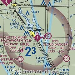
|
| Airport distance calculator |
|---|
|
|
| Sunrise and sunset |
|---|
|
Times for 16-Jun-2026
| | Local
(UTC-5) | | Zulu
(UTC) |
|---|
| Morning civil twilight | | 04:41 | | 09:41 |
| Sunrise | | 05:19 | | 10:19 |
| Sunset | | 20:56 | | 01:56 |
| Evening civil twilight | | 21:33 | | 02:33 |
|
| Current date and time |
|---|
| Zulu (UTC) | 16-Jun-2026 13:14:46 |
|---|
| Local (UTC-5) | 16-Jun-2026 08:14:46 |
|---|
|
| METAR |
|---|
| KY23 | 161255Z AUTO 00000KT 7SM RA OVC012 14/12 A2958 RMK AO2 P0001 T01440124
|
KRPD
10nm N | 161255Z AUTO 00000KT 10SM RA OVC016 13/11 A2959 RMK AO2 P0001 T01310110
|
KUBE
19nm NW | 161255Z AUTO 32003KT 10SM SCT009 BKN032 OVC075 14/12 A2958 RMK AO2
|
|
| TAF |
|---|
KEAU
27nm S | 161120Z 1612/1712 30007KT P6SM BKN040 FM161300 30008KT P6SM BKN025 TEMPO 1614/1618 6SM -SHRA FM161800 32012G21KT P6SM VCSH SCT025 BKN040 FM170100 VRB03KT P6SM BKN250
|
|
| NOTAMs |
|---|
NOTAMs are issued by the DoD/FAA and will open in a separate window not controlled by AirNav.
|
|

