FAA INFORMATION EFFECTIVE 14 MAY 2026
Location
| FAA Identifier: | Y58 |
| Lat/Long: | 44-14-58.7025N 094-42-37.5300W
44-14.978375N 094-42.625500W
44.2496396,-94.7104250
(estimated) |
| Elevation: | 1006 ft. / 307 m (estimated) |
| Variation: | 04E (1985) |
| From city: | 3 miles SE of SLEEPY EYE, MN |
| Time zone: | UTC -5 (UTC -6 during Standard Time) |
| Zip code: | 56085 |
Airport Operations
| Airport use: | Open to the public |
| Activation date: | 03/1947 |
| Control tower: | no |
| ARTCC: | MINNEAPOLIS CENTER |
| FSS: | PRINCETON FLIGHT SERVICE STATION |
| NOTAMs facility: | PNM (NOTAM-D service available) |
| Attendance: | UNATNDD |
| Wind indicator: | lighted |
| Segmented circle: | no |
| Lights: | ACTVT MIRL RWY 14/32 - CTAF. |
Airport Communications
| CTAF: | 122.9 |
| WX AWOS-3 at ULM (10 nm NE): | 118.325 (507-359-1656) |
| WX AWOS-3PT at JYG (17 nm SE): | 123.7 (507-375-7105) |
Nearby radio navigation aids
| VOR radial/distance | | VOR name | | Freq | | Var |
|---|
| RWFr119/22.2 | | REDWOOD FALLS VOR/DME | | 113.30 | | 07E |
Airport Services
| Parking: | hangars and tiedowns |
| Airframe service: | NONE |
| Powerplant service: | NONE |
| Bottled oxygen: | NONE |
| Bulk oxygen: | NONE |
Runway Information
Runway 14/32
| Dimensions: | 2575 x 300 ft. / 785 x 91 m |
| Surface: | turf, in good condition |
| Runway edge lights: | medium intensity |
| Runway edge markings: | YELLOW CONES. |
| RUNWAY 14 | | RUNWAY 32 |
| Latitude: | 44-15.157167N | | 44-14.824833N |
| Longitude: | 094-42.805167W | | 094-42.439833W |
| Elevation: | 1006.0 ft. | | 989.6 ft. |
| Traffic pattern: | left | | left |
| Runway end identifier lights: | no | | no |
| Touchdown point: | yes, no lights | | yes, no lights |
| Obstructions: | none | | 25 ft. trees, 223 ft. from runway, 142 ft. left of centerline, 8:1 slope to clear
+15 FT ROAD, 195 FT DIST, 0 FT B, 13:1; STOP SIGNS AT RWY EDGES. |
Runway 4/22
| Dimensions: | 2565 x 300 ft. / 782 x 91 m |
| Surface: | turf, in good condition |
| Runway edge markings: | YELLOW CONES. |
| Operational restrictions: | NOT PLOWED WINTER MONTHS. |
| RUNWAY 4 | | RUNWAY 22 |
| Latitude: | 44-14.819333N | | 44-15.112167N |
| Longitude: | 094-42.840000W | | 094-42.417000W |
| Elevation: | 991.8 ft. | | 994.8 ft. |
| Traffic pattern: | left | | left |
| Runway end identifier lights: | no | | no |
| Touchdown point: | yes, no lights | | yes, no lights |
| Obstructions: | 9 ft. crops, 99 ft. from runway, 114 ft. right of centerline, 11:1 slope to clear | | none |
Airport Ownership and Management from official FAA records
| Ownership: | Publicly-owned |
| Owner: | CITY OF SLEEPY EYE
200 MAIN ST E
SLEEPY EYE, MN 56085-1638
Phone 507-794-3731 |
| Manager: | LARRY LUND
26227 200TH ST
SLEEPY EYE, MN 56085-5118
Phone 507-794-7665
LTIEDEKEN@SLEEPYEYE-MN.COM. |
Additional Remarks
| - | SEWAGE DISPOSAL PONDS 1600 FT NORTH OF ARPT. |
| - | AGRICULTURE OPS ON & INVOF ARPT JUN-SEP. |
| - | FOR CD CTC MINNEAPOLIS ARTCC AT 651-463-5588. |
Instrument Procedures
There are no published instrument procedures at Y58.
Some nearby airports with instrument procedures:
KULM - New Ulm Municipal Airport (10 nm NE)
D42 - Springfield Municipal Airport (12 nm W)
KJYG - St James Municipal Airport (17 nm SE)
KRWF - Redwood Falls Municipal Airport (24 nm NW)
KMWM - Windom Municipal Airport (27 nm SW)
|
|

Road maps at:
MapQuest
Bing
Google
| Aerial photo |
|---|
WARNING: Photo may not be current or correct

Do you have a better or more recent aerial photo of Sleepy Eye Municipal Airport that you would like to share? If so, please send us your photo.
|
| Sectional chart |
|---|
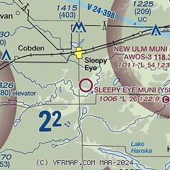
|
| Airport distance calculator |
|---|
|
|
| Sunrise and sunset |
|---|
|
Times for 10-Jun-2026
| | Local
(UTC-5) | | Zulu
(UTC) |
|---|
| Morning civil twilight | | 04:59 | | 09:59 |
| Sunrise | | 05:36 | | 10:36 |
| Sunset | | 21:01 | | 02:01 |
| Evening civil twilight | | 21:37 | | 02:37 |
|
| Current date and time |
|---|
| Zulu (UTC) | 10-Jun-2026 21:21:15 |
|---|
| Local (UTC-5) | 10-Jun-2026 16:21:15 |
|---|
|
| METAR |
|---|
KULM
10nm NE | 102055Z AUTO 26016G20KT 10SM CLR 32/19 A2950 RMK AO2
|
KJYG
17nm SE | 102055Z AUTO 25016G25KT 10SM CLR 33/16 A2949 RMK AO2
|
|
| TAF |
|---|
KRWF
24nm NW | 101903Z 1019/1118 24016G26KT P6SM VCTS SCT050CB FM102000 27015G23KT P6SM FEW200 FM110200 27010KT P6SM FEW250 FM110700 19004KT P6SM SCT100 FM111300 28008KT P6SM -SHRA BKN100
|
|
| NOTAMs |
|---|
NOTAMs are issued by the DoD/FAA and will open in a separate window not controlled by AirNav.
|
|

