FAA INFORMATION EFFECTIVE 14 MAY 2026
Location
| FAA Identifier: | IDA |
| Lat/Long: | 43-30-49.2240N 112-04-14.9530W
43-30.820400N 112-04.249217W
43.5136733,-112.0708203
(estimated) |
| Elevation: | 4743.7 ft. / 1445.9 m (surveyed) |
| Variation: | 12E (2020) |
| From city: | 2 miles NW of IDAHO FALLS, ID |
| Time zone: | UTC -6 (UTC -7 during Standard Time) |
| Zip code: | 83402 |
Airport Operations
| Airport use: | Open to the public |
| Activation date: | 04/1940 |
| Control tower: | yes |
| ARTCC: | SALT LAKE CITY CENTER |
| FSS: | BOISE FLIGHT SERVICE STATION |
| NOTAMs facility: | IDA (NOTAM-D service available) |
| Attendance: | 0530-2130
ON CALL 24 HRS PHONE 208-390-8746 OR 208-390-3624. |
| Pattern altitude: | TPA 1500 AGL (MULTI-ENG/TURBOJET ACFT), 1000 AGL (SGL ENG ACFT), 500 AGL (ROTORCRAFT). |
| Wind indicator: | lighted |
| Segmented circle: | yes |
| Lights: | WHEN ATCT CLSD, ACTVT MALSR RWY 21; REIL RWY 03; PAPI RWY 03; HIRL RWY 03/21 - CTAF. PAPI 17 & 35 U/S EXC WHEN ATCT AVBL. |
| Beacon: | white-green (lighted land airport)
Operates sunset to sunrise. |
| Fire and rescue: | ARFF index B |
| Airline operations: | 24 HR PPR FOR UNSKED ACR OPNS WITH MORE THAN 30 PAX SEATS CALL AMGR 208-612-8224. |
Airport Communications
| CTAF: | 118.5 |
| UNICOM: | 122.95 |
| ATIS: | 135.325 |
| WX ASOS: | PHONE 208-524-4553 |
| IDAHO FALLS GROUND: | 121.7 [0700-2000] |
| IDAHO FALLS TOWER: | 118.5 257.8 109.0T [0700-2000] |
| CLEARANCE DELIVERY: | 121.7 |
- APCH/DEP CTL SVC PRVDD BY SALT LAKE ARTCC (ZLC) ON FREQS 128.35/239.25 (ASHTON RCAG).
- FREQ 121.5 NOT AVBL.
- FSS 122.55
Nearby radio navigation aids
| VOR radial/distance | | VOR name | | Freq | | Var |
|---|
| IDA at field | | IDAHO FALLS VOR/DME | | 113.85 | | 15E |
| DBSr155/35.0 | | DUBOIS VORTAC | | 116.90 | | 15E |
Airport Services
| Fuel available: | 100LL JET-A1 |
| Parking: | hangars and tiedowns |
| Airframe service: | MAJOR |
| Powerplant service: | MAJOR |
| Bottled oxygen: | HIGH/LOW |
| Bulk oxygen: | HIGH/LOW |
Runway Information
Runway 3/21
| Dimensions: | 9002 x 150 ft. / 2744 x 46 m |
| Surface: | asphalt/grooved, in good condition |
| Weight bearing capacity: | | Single wheel: | 140.0 | | Double wheel: | 175.0 | | Double tandem: | 270.0 |
|
| Runway edge lights: | high intensity |
| RUNWAY 3 | | RUNWAY 21 |
| Latitude: | 43-30.150942N | | 43-31.318043N |
| Longitude: | 112-05.112817W | | 112-03.859282W |
| Elevation: | 4742.0 ft. | | 4731.3 ft. |
| Traffic pattern: | left | | left |
| Runway heading: | 026 magnetic, 038 true | | 206 magnetic, 218 true |
| Declared distances: | TORA:9002 TODA:9002 ASDA:9002 LDA:9002 | | TORA:9002 TODA:9002 ASDA:9002 LDA:9002 |
| Markings: | precision, in good condition | | precision, in good condition |
| Visual slope indicator: | 4-light PAPI on left (3.00 degrees glide path) | | 4-light PAPI on left (3.00 degrees glide path) |
| RVR equipment: | rollout | | touchdown |
| Approach lights: | | | MALSR: 1,400 foot medium intensity approach lighting system with runway alignment indicator lights |
| Runway end identifier lights: | yes | | |
| Touchdown point: | yes, no lights | | yes, no lights |
| Instrument approach: | | | ILS/DME |
Runway 17/35
| Dimensions: | 3964 x 75 ft. / 1208 x 23 m |
| Surface: | asphalt, in good condition |
| Weight bearing capacity: | | Single wheel: | 43.0 | | Double wheel: | 58.0 |
|
| Runway edge lights: | medium intensity |
| Operational restrictions: | CLSD NIGHTLY 2000-0700. |
| RUNWAY 17 | | RUNWAY 35 |
| Latitude: | 43-31.341405N | | 43-30.689380N |
| Longitude: | 112-03.696193W | | 112-03.726190W |
| Elevation: | 4731.1 ft. | | 4731.2 ft. |
| Traffic pattern: | left | | left |
| Runway heading: | 170 magnetic, 182 true | | 350 magnetic, 002 true |
| Markings: | basic, in good condition | | basic, in good condition |
| Visual slope indicator: | 2-light PAPI on left (3.00 degrees glide path) | | 4-light PAPI on left (3.50 degrees glide path) |
| Touchdown point: | yes, no lights | | yes, no lights |
| Obstructions: | none | | 23 ft. ant, 700 ft. from runway, 80 ft. left of centerline, 21:1 slope to clear |
Airport Ownership and Management from official FAA records
| Ownership: | Publicly-owned |
| Owner: | CITY OF IDAHO FALLS
PO BOX 50220
IDAHO FALLS, ID 83405
Phone 208-612-8224 |
| Manager: | IAN TURNER
2140 N SKYLINE
IDAHO FALLS, ID 83402
Phone (208) 612-8224
AIRPORT DIRECTOR |
Additional Remarks
| A39-03/21 | PCR VALUE: 700/F/B/X/T |
| A39-17/35 | PCR VALUE: 160/F/D/X/T |
| - | FQT VEHICLE TFC ON EAST RAMP ADJ TO TWY B. |
| - | FOR CD IF UNA TO CTC ON FSS FREQ, CTC SALT LAKE ARTCC AT 801-320-2568. |
| - | FLOCKS OF BIRDS & WATERFOWL ON & INVOF ARPT ALL YEAR. |
| - | EXTSV AGRICULTURAL OPNS INVOF OF ARPT. |
| - | ACFT OPS BE ALERT FOR POSSIBLE INCURSIONS; NO LINE OF SIGHT BTN RWYS. |
| - | SFC CONDITIONS UNMONITORED 2300-0530. |
| - | RWY 21 AND RWY 17 APCH ENDS IN CLOSE PROXIMITY. WRONG RWY DEP/ARR RISK. CHK RWY ALNMT. INTERSECTING FLT PATHS FOR RWYS 21 & 17, AND RWYS 03 & 35. |
| - | SELF SVC FUEL EAST OF TWY BRAVO AVBL 24 HRS. |
| - | ALL COMMERCIAL ACFT ADVISE PRIOR TO PUSHBACK. |
| - | IDA SVC GND COM OUTLET CMSND KEY FREQ 121.725: 2 TIMES FUEL DLVY; 4 TIMES SLC ARTCC; 6 TIMES BOI FSS; 8 TIMES 911 DISPATCH SVC WHEN TWR CLSD. |
Instrument Procedures
NOTE: All procedures below are presented as PDF files. If you need a reader for these files, you should download the free Adobe Reader.NOT FOR NAVIGATION. Please procure official charts for flight.
FAA instrument procedures published for use from 14 May 2026 at 0901Z to 11 June 2026 at 0900Z.
IAPs - Instrument Approach Procedures |
|---|
| ILS OR LOC RWY 21 | |
download (277KB) |
| RNAV (RNP) Z RWY 03 | |
download (247KB) |
| RNAV (RNP) Z RWY 21 | |
download (250KB) |
| RNAV (GPS) Y RWY 03 | |
download (229KB) |
| RNAV (GPS) Y RWY 21 | |
download (264KB) |
| LOC BC RWY 03 | |
download (258KB) |
| VOR RWY 03 | |
download (181KB) |
| VOR RWY 21 | |
download (195KB) |
| NOTE: Special Alternate Minimums apply | |
download (187KB) |
Departure Procedures |
|---|
| FAHLZ ONE (RNAV) | |
download (142KB) |
| IYEFF ONE (RNAV) | |
download (148KB) |
| NOTE: Special Take-Off Minimums/Departure Procedures apply | |
download (223KB) |
Other nearby airports with instrument procedures:
U02 - McCarley Field Airport (22 nm SW)
KRXE - Rexburg-Madison County Airport (22 nm NE)
KPIH - Pocatello Regional Airport (43 nm SW)
KDIJ - Driggs/Reed Memorial Airport (45 nm E)
KAOC - Arco-Butte County Airport (55 nm W)
|
|

Road maps at:
MapQuest
Bing
Google
| Aerial photo |
|---|
WARNING: Photo may not be current or correct
 Photo by Colleen Kendall
Photo taken 13-Aug-2013
looking southwest.
Photo by Colleen Kendall
Photo taken 13-Aug-2013
looking southwest.
Do you have a better or more recent aerial photo of Idaho Falls Regional Airport that you would like to share? If so, please send us your photo.
|
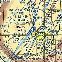
| Sectional chart |
|---|
|
CAUTION: Diagram may not be current
 Download PDF
of official airport diagram from the FAA
| Airport distance calculator |
|---|
|
|
| Sunrise and sunset |
|---|
|
Times for 23-May-2026
| | Local
(UTC-6) | | Zulu
(UTC) |
|---|
| Morning civil twilight | | 05:23 | | 11:23 |
| Sunrise | | 05:57 | | 11:57 |
| Sunset | | 20:53 | | 02:53 |
| Evening civil twilight | | 21:27 | | 03:27 |
|
| Current date and time |
|---|
| Zulu (UTC) | 24-May-2026 02:21:45 |
|---|
| Local (UTC-6) | 23-May-2026 20:21:45 |
|---|
|
| METAR |
|---|
| KIDA | 240153Z 25006KT 10SM FEW120 22/02 A2989 RMK AO2 SLP093 T02170017
|
|
| TAF |
|---|
| KIDA | 231721Z 2318/2418 22012G22KT P6SM FEW080 SCT150 FM240200 20007KT P6SM FEW070 BKN100 FM241000 VRB04KT P6SM SCT120
|
|
| NOTAMs |
|---|
NOTAMs are issued by the DoD/FAA and will open in a separate window not controlled by AirNav.
|
|


