FAA INFORMATION EFFECTIVE 17 APRIL 2025
Location
| FAA Identifier: | DUA |
| Lat/Long: | 33-56-22.9110N 096-23-42.2070W
33-56.381850N 096-23.703450W
33.9396975,-96.3950575
(estimated) |
| Elevation: | 699.1 ft. / 213.1 m (surveyed) |
| Variation: | 05E (2000) |
| From city: | 3 miles SW of DURANT, OK |
| Time zone: | UTC -5 (UTC -6 during Standard Time) |
| Zip code: | 74701 |
Airport Operations
| Airport use: | Open to the public |
| Activation date: | 09/1943 |
| Control tower: | no |
| ARTCC: | FORT WORTH CENTER |
| FSS: | MC ALESTER FLIGHT SERVICE STATION |
| NOTAMs facility: | DUA (NOTAM-D service available) |
| Attendance: | 0700-1900
AFT HR ON REQ. |
| Wind indicator: | lighted |
| Segmented circle: | yes |
| Lights: | ACTVT ODALS RWY 17; MIRL RWY 17/35; TWY LGTS - CTAF. PAPI RWY 17 & 35 ON CONSLY. |
| Beacon: | white-green (lighted land airport)
Operates sunset to sunrise. |
Airport Communications
| CTAF/UNICOM: | 123.05 |
| WX AWOS-3: | 124.175 (580-931-3790) |
| WX AWOS-3 at GYI (19 nm SW): | 118.775 (903-786-7790) |
- APCH/DEP CTL SVC PRVDD BY FORT WORTH ARTCC (ZFW) ON FREQS 124.75/323.0 (GAINESVILLE RCAG).
Nearby radio navigation aids
| VOR radial/distance | | VOR name | | Freq | | Var |
|---|
| BYPr336/25.4 | | BONHAM VORTAC | | 114.60 | | 06E |
| NDB name | | Hdg/Dist | | Freq | | Var | | ID |
|---|
| DENISON | | 061/15.2 | | 341 | | 03E | | DNI | -.. -. .. |
Airport Services
| Fuel available: | 100LL JET-A+
100LL:AFT HR FUEL - 580-579-5024. |
| Parking: | hangars and tiedowns |
| Airframe service: | MAJOR |
| Powerplant service: | MAJOR |
| Bottled oxygen: | HIGH |
| Bulk oxygen: | HIGH |
Runway Information
Runway 17/35
| Dimensions: | 6800 x 100 ft. / 2073 x 30 m |
| Surface: | asphalt, in good condition |
| Weight bearing capacity: | | Single wheel: | 66.0 | | Double wheel: | 82.0 | | Double tandem: | 157.0 |
|
| Runway edge lights: | medium intensity |
| RUNWAY 17 | | RUNWAY 35 |
| Latitude: | 33-56.942355N | | 33-55.821332N |
| Longitude: | 096-23.699425W | | 096-23.707487W |
| Elevation: | 699.1 ft. | | 693.7 ft. |
| Traffic pattern: | left | | left |
| Runway heading: | 175 magnetic, 180 true | | 355 magnetic, 000 true |
| Markings: | nonprecision, in good condition | | nonprecision, in good condition |
| Visual slope indicator: | 4-light PAPI on left (3.00 degrees glide path) | | 4-light PAPI on left (3.00 degrees glide path) |
| Approach lights: | ODALS: omnidirectional approach lighting system | | |
| Runway end identifier lights: | no | | no |
| Touchdown point: | yes, no lights | | yes, no lights |
| Obstructions: | 33 ft. trees, 1164 ft. from runway, 356 ft. right of centerline, 29:1 slope to clear | | 31 ft. trees, 1028 ft. from runway, 437 ft. left of centerline, 26:1 slope to clear |
Airport Ownership and Management from official FAA records
| Ownership: | Publicly-owned |
| Owner: | CITY OF DURANT
301 W EVERGREEN
DURANT, OK 74701
Phone (580) 920-0574 |
| Manager: | JOSH MATEKOVIC
10 WALDRON DR
DURANT, OK 74701
Phone 580-579-5024
AFT HR - 580-579-5024. |
Additional Remarks
| A39-17/35 | PCR VALUE: 226/R/B/X/T |
| - | 372 FT TWR 2.5 MI N. |
| - | STUDENT TRNG INVOF ARPT & OVR LAKE TEXOMA. |
| - | FOR CD CTC FORT WORTH ARTCC AT 817-858-7584. |
| - | AFT HR - 580-579-5024. |
Instrument Procedures
NOTE: All procedures below are presented as PDF files. If you need a reader for these files, you should download the free Adobe Reader.NOT FOR NAVIGATION. Please procure official charts for flight.
FAA instrument procedures published for use from 17 April 2025 at 0901Z to 15 May 2025 at 0900z.
IAPs - Instrument Approach Procedures |
|---|
| RNAV (GPS) RWY 17 | |
download (204KB) |
| RNAV (GPS) RWY 35 | |
download (229KB) |
| NOTE: Special Alternate Minimums apply | |
download (121KB) |
| NOTE: Special Take-Off Minimums/Departure Procedures apply | |
download (378KB) |
Other nearby airports with instrument procedures:
KGYI - North Texas Regional Airport/Perrin Field (19 nm SW)
KSWI - Sherman Municipal Airport (21 nm SW)
F00 - Jones Field Airport (22 nm SE)
1F4 - Madill Municipal Airport (24 nm NW)
KADM - Ardmore Municipal Airport (38 nm NW)
|
|

Road maps at:
MapQuest
Bing
Google
| Aerial photo |
|---|
WARNING: Photo may not be current or correct
 Taken in the Fall of 2008
Do you have a better or more recent aerial photo of Durant Regional Airport - Eaker Field that you would like to share? If so, please send us your photo.
|
| Sectional chart |
|---|
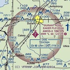
|
| Airport distance calculator |
|---|
|
|
| Sunrise and sunset |
|---|
|
Times for 10-May-2025
| | Local
(UTC-5) | | Zulu
(UTC) |
|---|
| Morning civil twilight | | 06:02 | | 11:02 |
| Sunrise | | 06:29 | | 11:29 |
| Sunset | | 20:15 | | 01:15 |
| Evening civil twilight | | 20:42 | | 01:42 |
|
| Current date and time |
|---|
| Zulu (UTC) | 10-May-2025 13:24:36 |
|---|
| Local (UTC-5) | 10-May-2025 08:24:36 |
|---|
|
| METAR |
|---|
| KDUA | 101255Z AUTO 01010KT 10SM CLR 16/15 A3014 RMK AO2
|
KGYI
19nm SW | 101250Z 35005KT 10SM CLR 16/14 A3013
|
|
| TAF |
|---|
| KDUA | 101120Z 1012/1112 01004KT P6SM FEW250 FM101500 02011G16KT P6SM BKN040 FM110100 36006KT P6SM BKN250
|
|
| NOTAMs |
|---|
NOTAMs are issued by the DoD/FAA and will open in a separate window not controlled by AirNav.
|
|


