FAA INFORMATION EFFECTIVE 25 DECEMBER 2025
Location
| FAA Identifier: | FRG |
| Lat/Long: | 40-43-45.3870N 073-24-48.3150W
40-43.756450N 073-24.805250W
40.7292742,-73.4134208
(estimated) |
| Elevation: | 81.6 ft. / 24.9 m (surveyed) |
| Variation: | 14W (2000) |
| From city: | 1 mile E of FARMINGDALE, NY |
| Time zone: | UTC -5 (UTC -4 during Daylight Saving Time) |
| Zip code: | 11735 |
Airport Operations
| Airport use: | Open to the public |
| Activation date: | 03/1940 |
| Control tower: | yes |
| ARTCC: | NEW YORK CENTER |
| FSS: | NEW YORK FLIGHT SERVICE STATION |
| NOTAMs facility: | FRG (NOTAM-D service available) |
| Attendance: | CONTINUOUS |
| Pattern altitude: | 1181.6 ft. MSL
TPA: 1100 FT AGL RECIPROCATING ENG, 1600 FT AGL TURBOPROP/JET. |
| Wind indicator: | lighted |
| Segmented circle: | yes |
| Lights: | WHEN ATCT CLSD ACTVT MALSF RWY 14; REIL RWY 01, 19, 32; PAPI RWY 01, 19, 14, 32; HIRL RWY 14/32; MIRL RWY 01/19; TWY LGTS - CTAF. |
| Beacon: | white-green (lighted land airport)
Operates sunset to sunrise. |
| Landing fee: | yes, LNDG FEE FOR ALL ACFT EXCP MIL/GOVT. |
| Fire and rescue: | ARFF index A |
| Airline operations: | INDEX B AVBL ON REQ CALL 631-752-7707. |
| International operations: | customs landing rights airport |
Airport Communications
| CTAF: | 118.8 |
| UNICOM: | 122.95 |
| ATIS: | 126.65 |
| WX ASOS: | PHONE 631-752-8129 |
| REPUBLIC GROUND: | 121.6 269.6 [0700-2300] |
| REPUBLIC TOWER: | 118.8 279.65 125.2 [0700-2300] |
| NEW YORK APPROACH: | 128.125 118.4 123.7 132.4 134.35 |
| NEW YORK DEPARTURE: | 125.7 123.7 134.35 |
| CLEARANCE DELIVERY: | 128.25 128.25 ;WHEN FRG TWR CLSD |
| CAMRN STAR: | 128.125 |
| IC: | 128.125 |
| KINGSTON STAR: | 128.125 |
| LENDY STAR: | 128.125 |
| PAWLN STAR: | 133.1 |
| PUCKY: | 128.125 |
| WX ASOS at ISP (15 nm E): | 120.725 (631-471-0131) |
| WX ASOS at JFK (17 nm W): | PHONE 718-656-0956 |
Nearby radio navigation aids
| VOR radial/distance | | VOR name | | Freq | | Var |
|---|
| DPKr245/6.2 | | DEER PARK VOR/DME | | 117.70 | | 12W |
| JFKr082/17.3 | | KENNEDY VOR/DME | | 115.90 | | 12W |
| LGAr111/20.9 | | LA GUARDIA VOR/DME | | 113.10 | | 12W |
| CRIr083/23.0 | | CANARSIE VOR/DME | | 112.30 | | 11W |
| BDRr219/29.0 | | BRIDGEPORT VOR/DME | | 108.80 | | 12W |
| TEBr115/30.3 | | TETERBORO VOR/DME | | 108.40 | | 11W |
| CCCr260/30.4 | | CALVERTON VOR/DME | | 114.55 | | 13W |
| CMKr179/33.9 | | CARMEL VOR/DME | | 116.60 | | 12W |
| NDB name | | Hdg/Dist | | Freq | | Var | | ID |
|---|
| FRIKK | | 146/4.2 | | 407 | | 14W | | FR | ..-. .-. |
| LOKKS | | 284/10.1 | | 366 | | 14W | | IS | .. ... |
Airport Services
| Fuel available: | 100LL JET-A |
| Parking: | hangars and tiedowns |
| Airframe service: | MAJOR |
| Powerplant service: | MAJOR |
| Bottled oxygen: | HIGH/LOW |
| Bulk oxygen: | HIGH/LOW |
Runway Information
Runway 14/32
| Dimensions: | 6833 x 150 ft. / 2083 x 46 m |
| Surface: | asphalt/grooved, in good condition |
| Weight bearing capacity: | | Single wheel: | 45.0 | | Double wheel: | 60.0 |
|
| Runway edge lights: | high intensity |
| RUNWAY 14 | | RUNWAY 32 |
| Latitude: | 40-44.077932N | | 40-43.321412N |
| Longitude: | 073-25.304157W | | 073-24.209248W |
| Elevation: | 77.9 ft. | | 61.4 ft. |
| Traffic pattern: | left | | right |
| Runway heading: | 146 magnetic, 132 true | | 326 magnetic, 312 true |
| Displaced threshold: | 675 ft. | | no |
| Declared distances: | TORA:6833 TODA:6833 ASDA:6833 LDA:6157 | | TORA:6833 TODA:6833 ASDA:6833 LDA:6833 |
| Markings: | precision, in good condition | | nonprecision, in good condition |
| Visual slope indicator: | 4-light PAPI on left (3.00 degrees glide path) | | 4-light PAPI on left (3.00 degrees glide path) |
| Approach lights: | MALSF: 1,400 foot medium intensity approach lighting system with sequenced flashers | | |
| Runway end identifier lights: | | | yes |
| Touchdown point: | yes, no lights | | yes, no lights |
| Instrument approach: | ILS | | |
| Obstructions: | 23 ft. pole, 400 ft. from runway, 390 ft. right of centerline, 8:1 slope to clear
8 FT FENCE 0-200 FT FM RWY END, 240 FT LEFT. | | 26 ft. road, 200 ft. from runway, 1:1 slope to clear
8 FT FENCE 180 FT FM RWY END 500 FT LEFT; 8 FT LGTD BLAST FENCE AT AER 460 FT RIGHT. |
Runway 1/19
| Dimensions: | 5517 x 150 ft. / 1682 x 46 m |
| Surface: | asphalt/grooved, in fair condition |
| Weight bearing capacity: | | Single wheel: | 45.0 | | Double wheel: | 60.0 |
|
| Runway edge lights: | medium intensity |
| RUNWAY 1 | | RUNWAY 19 |
| Latitude: | 40-43.372570N | | 40-44.280953N |
| Longitude: | 073-24.856877W | | 073-24.874027W |
| Elevation: | 63.7 ft. | | 81.4 ft. |
| Traffic pattern: | right | | left |
| Runway heading: | 013 magnetic, 359 true | | 193 magnetic, 179 true |
| Declared distances: | TORA:5517 TODA:5517 ASDA:5517 LDA:5517 | | TORA:5516 TODA:5516 ASDA:5516 LDA:5516 |
| Markings: | nonprecision, in good condition | | nonprecision, in good condition |
| Visual slope indicator: | 4-light PAPI on left (3.09 degrees glide path) | | 4-light PAPI on left (3.10 degrees glide path)
PAPI UNUSBL BYD 4 DEG LEFT OF CNTRLN. |
| Runway end identifier lights: | yes | | yes |
| Touchdown point: | yes, no lights | | yes, no lights |
| Obstructions: | 29 ft. pole, lighted, 775 ft. from runway, 210 ft. left of centerline, 19:1 slope to clear | | 41 ft. bldg, lighted, 250 ft. from runway, 250 ft. left of centerline, 1:1 slope to clear |
Helipad H1
| Dimensions: | 79 x 79 ft. / 24 x 24 m |
| Surface: | asphalt, in good condition |
| Operational restrictions: | LCTD ON TWY B AT THE INTXN OF TWY F. |
| Latitude: | 40-43.990300N | | |
| Longitude: | 073-24.942828W | | |
| Elevation: | 75.5 ft. | | |
| Traffic pattern: | left | | left |
| Markings: | NSTD, in poor condition | | |
Helipad H2
| Dimensions: | 44 x 44 ft. / 13 x 13 m |
| Surface: | asphalt, in good condition |
| Operational restrictions: | LCTD ON TWY B NORTH OF TWY B6. |
| Latitude: | 40-43.483310N | | |
| Longitude: | 073-24.923963W | | |
| Elevation: | 66.0 ft. | | |
| Traffic pattern: | left | | left |
| Markings: | NSTD, in poor condition | | |
Airport Ownership and Management from official FAA records
| Ownership: | Publicly-owned |
| Owner: | NEW YORK STATE DEPT TRANS
1220 WASHINGTON AVE
ALBANY, NY 12232
Phone 518-457-2821 |
| Manager: | JOHN LAUTH
7150 REPUBLIC ARPT. STE. 216
E FARMINGDALE, NY 11735
Phone 631-752-7707
EXTENSION 6108. |
Additional Remarks
| A39-01/19 | PCR VALUE: 565/F/C/X/T |
| A39-14/32 | PCR VALUE: 476/F/B/X/T |
| E60-32 | ENGINEERED MATERIALS ARRESTING SYSTEM (EMAS) 404 FT LENGTH BY 170 FT WIDTH LCTD AT DER 32. |
| E60-14 | ENGINEERED MATERIALS ARRESTING SYSTEM (EMAS) 384 FT LENGTH BY 170 FT WIDTH LCTD AT DER 14. |
| - | BIRDS INVOF ARPT. |
| - | VOLUNTARY NOISE ABATEMENT PROCS IN EFCT FOR FIXED WING & HEL. CTC AMGR 631-752-7707 EXT 6108. |
| - | LNDG FEE FOR ALL ACFT EXCP MIL & GOVT. |
| - | JET MAINT RUNUPS PMTD ONLY IN THE TWY A, D, F & G HLDG BAYS. |
| - | WOODED AREA S OF TWY A, E OF TWY G CLSD TO HELS. |
| - | NOTE: SEE LND & HOLD SHRT OPS SECTION. |
| - | ACFT PRKG FOR US CUST IS LCTD ON THE MAIN TRML RAMP. ALL INTL ARRS MUST CTC FBO FOR SVC WHEN CLRG CUST. TRML USE FEES APPLY. |
| - | ALL INTL ARRS MUST NOT ENTER THE MAIN TRML RAMP TIL FBO PSNL ARE PRESENT FOR MARSHALLING. CTC ARPT OPS ON 122.95 MHZ FOR INSTRUCTIONS. |
| - | FOR CD WHEN ATCT CLSD CTC NEW YORK APCH ON 128.25, IF UNA CALL 516-683-2962. |
| - | (DSPLCD THR APCH RATIO, RWY 19) APCH SLP 25:1 TO DTHR. |
| - | (DSPLCD THR APCH RATIO, RWY 14) APCH SLP 46:1 TO DTHR. |
Instrument Procedures
NOTE: All procedures below are presented as PDF files. If you need a reader for these files, you should download the free Adobe Reader.NOT FOR NAVIGATION. Please procure official charts for flight.
FAA instrument procedures published for use from 25 December 2025 at 0901z to 22 January 2026 at 0900z.
STARs - Standard Terminal Arrivals |
|---|
| KINGSTON ONE | |
download (157KB) |
| LENDY EIGHT | |
download (161KB) |
| PARCH FOUR (RNAV) | |
download (259KB) |
| PAWLN ONE (RNAV) | |
download (171KB) |
| PUCKY ONE (RNAV) | |
download (202KB) |
| SARDI ONE (RNAV) | |
2 pages:
[1] [2] (474KB) |
IAPs - Instrument Approach Procedures |
|---|
| ILS OR LOC RWY 14 | |
download (243KB) |
| RNAV (RNP) Z RWY 14 | |
download (212KB) |
| RNAV (GPS) RWY 01 | |
download (249KB) |
| RNAV (GPS) RWY 19 | |
download (240KB) |
| RNAV (GPS) RWY 32 | |
download (243KB) |
| RNAV (GPS) Y RWY 14 | |
download (277KB) |
| NOTE: Special Alternate Minimums apply | |
download (122KB) |
Departure Procedures |
|---|
| DEEZZ FIVE (RNAV) | |
download (209KB) |
| REPUBLIC ONE | |
download (211KB) |
| NOTE: Special Take-Off Minimums/Departure Procedures apply | |
download (245KB) |
Other nearby airports with instrument procedures:
KISP - Long Island Mac Arthur Airport (15 nm E)
KJFK - John F Kennedy International Airport (17 nm W)
KLGA - LaGuardia Airport (21 nm W)
KHPN - Westchester County Airport (24 nm NW)
6N5 - East 34th Street Heliport (25 nm W)
|
|

Road maps at:
MapQuest
Bing
Google
| Aerial photo |
|---|
WARNING: Photo may not be current or correct
 Photo by Rob Donner
Taken in 2020
looking northwest.
Photo by Rob Donner
Taken in 2020
looking northwest.
Do you have a better or more recent aerial photo of Republic Airport that you would like to share? If so, please send us your photo.
|
| Sectional chart |
|---|
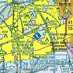
|
CAUTION: Diagram may not be current
 Download PDF
of official airport diagram from the FAA
| Airport distance calculator |
|---|
|
|
| Sunrise and sunset |
|---|
|
Times for 05-Jan-2026
| | Local
(UTC-5) | | Zulu
(UTC) |
|---|
| Morning civil twilight | | 06:48 | | 11:48 |
| Sunrise | | 07:19 | | 12:19 |
| Sunset | | 16:39 | | 21:39 |
| Evening civil twilight | | 17:10 | | 22:10 |
|
| Current date and time |
|---|
| Zulu (UTC) | 05-Jan-2026 19:58:13 |
|---|
| Local (UTC-5) | 05-Jan-2026 14:58:13 |
|---|
|
| METAR |
|---|
| KFRG | 051953Z 20013KT 10SM BKN120 02/M05 A3013 RMK AO2 SLP203 T00171050
|
KISP
15nm E | 051856Z 21008KT 10SM FEW045 BKN060 OVC110 01/M04 A3015 RMK SLPNO T00111044
|
KJFK
17nm W | 051951Z 19011KT 10SM FEW055 SCT120 BKN180 BKN250 01/M06 A3014 RMK AO2 SNE31 SLP207 P0000 T00111061 $
|
|
| TAF |
|---|
KISP
15nm E | 051740Z 0518/0618 19008KT P6SM OVC070 PROB30 0518/0522 4SM -SN BKN030 FM052200 22006KT P6SM BKN040 FM060700 VRB04KT P6SM SCT040 SCT200
|
KJFK
17nm W | 051740Z 0518/0624 19010KT P6SM OVC060 PROB30 0518/0521 4SM -SN BKN030 FM060000 22008KT P6SM BKN040 FM060700 VRB05KT P6SM FEW040 SCT200 FM061800 11005KT P6SM BKN150
|
|
| NOTAMs |
|---|
NOTAMs are issued by the DoD/FAA and will open in a separate window not controlled by AirNav.
|
|


