FAA INFORMATION EFFECTIVE 15 MAY 2025
Location
| FAA Identifier: | PVC |
| Lat/Long: | 42-04-20.2000N 070-13-14.6000W
42-04.336667N 070-13.243333W
42.0722778,-70.2207222
(estimated) |
| Elevation: | 7.8 ft. / 2.4 m (surveyed) |
| Variation: | 16W (1995) |
| From city: | 2 miles NW of PROVINCETOWN, MA |
| Time zone: | UTC -4 (UTC -5 during Standard Time) |
| Zip code: | 02657 |
Airport Operations
| Airport use: | Open to the public |
| Activation date: | 04/1940 |
| Control tower: | no |
| ARTCC: | BOSTON CENTER |
| FSS: | BRIDGEPORT FLIGHT SERVICE STATION |
| NOTAMs facility: | PVC (NOTAM-D service available) |
| Attendance: | MAY-OCT 0600-1800, NOV-APR MON-SAT 0600-1700, NOV-APR SUN 0600-1700 |
| Wind indicator: | yes |
| Segmented circle: | yes |
| Lights: | ACTVT MALSF RWY 07; REIL RWY 25; PAPI RWY 07 & 25; HIRL RWY 07/25 - 122.85. |
| Beacon: | white-green (lighted land airport)
Operates sunset to sunrise. |
| Landing fee: | yes, PRKG FEE. |
Airport Communications
| CTAF/UNICOM: | 122.8 |
| WX AWOS-3PT: | 119.275 (508-487-6435) |
| BOSTON APPROACH: | 118.2 |
| BOSTON DEPARTURE: | 118.2 |
| CLEARANCE DELIVERY: | 120.65 |
Nearby radio navigation aids
| VOR radial/distance | | VOR name | | Freq | | Var |
|---|
| LFVr308/8.8 | | MARCONI VOR/DME | | 114.70 | | 16W |
| BOSr133/38.2 | | BOSTON VOR/DME | | 112.70 | | 16W |
| NDB name | | Hdg/Dist | | Freq | | Var | | ID |
|---|
| PROVINCETOWN | | at field | | 389 | | 16W | | PVC | .--. ...- -.-. |
| NAUSET | | 351/25.1 | | 279 | | 16W | | CQX | -.-. --.- -..- |
Airport Services
| Fuel available: | 100LL JET-A+
100LL:FOR AVBLTY - AMGR. |
| Parking: | tiedowns |
| Airframe service: | NONE |
| Powerplant service: | NONE |
| Bottled oxygen: | NONE |
| Bulk oxygen: | NONE |
Runway Information
Runway 7/25
| Dimensions: | 3502 x 100 ft. / 1067 x 30 m |
| Surface: | asphalt, in good condition |
| Weight bearing capacity: | |
| Runway edge lights: | high intensity |
| RUNWAY 7 | | RUNWAY 25 |
| Latitude: | 42-04.189783N | | 42-04.484083N |
| Longitude: | 070-13.576812W | | 070-12.911400W |
| Elevation: | 7.6 ft. | | 7.8 ft. |
| Traffic pattern: | left | | right |
| Runway heading: | 075 magnetic, 059 true | | 255 magnetic, 239 true |
| Markings: | precision, in good condition | | precision, in good condition |
| Visual slope indicator: | 4-light PAPI on right (3.00 degrees glide path) | | 4-light PAPI on left (3.00 degrees glide path) |
| Approach lights: | MALSF: 1,400 foot medium intensity approach lighting system with sequenced flashers | | |
| Runway end identifier lights: | no | | yes |
| Touchdown point: | yes, no lights | | yes, no lights |
| Instrument approach: | ILS/DME | | |
| Obstructions: | none | | 12 ft. trees, 610 ft. from runway, 125 ft. left of centerline, 34:1 slope to clear |
Airport Ownership and Management from official FAA records
| Ownership: | Publicly-owned |
| Owner: | DEPT OF INTERIOR NATL PARK SERVICE
CAPE COD NATIONAL SEASHORE
SOUTH WELLFLEET, MA 02663
Phone 508-487-2100 |
| Manager: | WILLIAM JURASCHEK
PROVINCETOWN AIRPORT
PROVINCETOWN, MA 02657
Phone 508-487-0241 |
Additional Remarks
| A96 | ULTRALIGHT OPS NA MAY 1 - SEP 30. |
| - | WILDLIFE ON & INVOF ARPT. |
| - | CTN: HIGH SPD MIL & HEL TFC INVOF CAPE COD CGAS. |
| - | SAWRS. |
| - | FOR CD CTC BOSTON APCH AT 603-594-5554. |
Instrument Procedures
NOTE: All procedures below are presented as PDF files. If you need a reader for these files, you should download the free Adobe Reader.NOT FOR NAVIGATION. Please procure official charts for flight.
FAA instrument procedures published for use from 15 May 2025 at 0901Z to 13 June 2025 at 0900z.
IAPs - Instrument Approach Procedures |
|---|
| ILS OR LOC RWY 07 | |
download (303KB) |
| RNAV (GPS) RWY 07 | |
download (256KB) |
| RNAV (GPS) RWY 25 | |
download (203KB) |
| NDB RWY 25 | |
download (196KB) |
| NOTE: Special Alternate Minimums apply | |
download (43KB) |
| NOTE: Special Take-Off Minimums/Departure Procedures apply | |
download (178KB) |
Other nearby airports with instrument procedures:
KGHG - Marshfield Municipal Airport - George Harlow Field (20 nm W)
KHYA - Cape Cod Gateway Airport (24 nm S)
KPYM - Plymouth Municipal Airport (25 nm SW)
KCQX - Chatham Municipal Airport (25 nm SE)
KFMH - Cape Cod Coast Guard Air Station (28 nm SW)
|
|

Road maps at:
MapQuest
Bing
Google
| Aerial photo |
|---|
WARNING: Photo may not be current or correct
 Photo by Karl Swenson
Photo taken 08-Jun-2020
looking northeast.
Photo by Karl Swenson
Photo taken 08-Jun-2020
looking northeast.
Do you have a better or more recent aerial photo of Provincetown Municipal Airport that you would like to share? If so, please send us your photo.
|
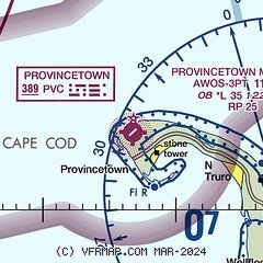
| Sectional chart |
|---|
|
| Airport distance calculator |
|---|
|
|
| Sunrise and sunset |
|---|
|
Times for 31-May-2025
| | Local
(UTC-4) | | Zulu
(UTC) |
|---|
| Morning civil twilight | | 04:35 | | 08:35 |
| Sunrise | | 05:09 | | 09:09 |
| Sunset | | 20:08 | | 00:08 |
| Evening civil twilight | | 20:42 | | 00:42 |
|
| Current date and time |
|---|
| Zulu (UTC) | 01-Jun-2025 02:11:13 |
|---|
| Local (UTC-4) | 31-May-2025 22:11:13 |
|---|
|
| METAR |
|---|
| KPVC | 010156Z AUTO 26014KT 10SM BKN015 BKN020 OVC029 14/13 A2930 RMK AO2 RAB14E39 SLP922 T01390133 PNO $
|
|
| TAF |
|---|
KHYA
24nm S | 311734Z 3118/0118 21025G34KT P6SM SCT005 FM312000 24027G40KT P6SM BKN040 FM010400 26012KT P6SM BKN050 FM011600 24015G26KT P6SM SCT250
|
KFMH
29nm SW | 311734Z 3118/0118 22025G35KT P6SM SCT015 BKN050 FM312000 24027G40KT P6SM BKN040 FM010400 26012KT P6SM BKN050 FM011600 24015G26KT P6SM SCT250
|
|
| NOTAMs |
|---|
NOTAMs are issued by the DoD/FAA and will open in a separate window not controlled by AirNav.
|
|


