FAA INFORMATION EFFECTIVE 17 APRIL 2025
Location
| FAA Identifier: | PPF |
| Lat/Long: | 37-19-50.9290N 095-30-22.2300W
37-19.848817N 095-30.370500W
37.3308136,-95.5061750
(estimated) |
| Elevation: | 900.5 ft. / 274.5 m (surveyed) |
| Variation: | 06E (1985) |
| From city: | 11 miles W of PARSONS, KS |
| Time zone: | UTC -5 (UTC -6 during Standard Time) |
| Zip code: | 67335 |
Airport Operations
| Airport use: | Open to the public |
| Activation date: | 02/1944 |
| Control tower: | no |
| ARTCC: | KANSAS CITY CENTER |
| FSS: | WICHITA FLIGHT SERVICE STATION |
| NOTAMs facility: | PPF (NOTAM-D service available) |
| Attendance: | MON-FRI 0800-1700 |
| Wind indicator: | lighted |
| Segmented circle: | no |
| Lights: | DUSK-2300. MIRL RY 17/35 OPER DUSK-2300; AFT 2300 ACTVT - CTAF. ACTVT VASI AND REIL RYS 17 & 35 - CTAF. |
| Beacon: | white-green (lighted land airport)
Operates sunset to sunrise. |
Airport Communications
| CTAF/UNICOM: | 123.0 |
| WX ASOS: | 118.175 (620-336-3834) |
| WX ASOS at CFV (15 nm S): | 121.275 (620-251-1959) |
| WX AWOS-3PT at IDP (17 nm SW): | 118.525 (620-331-5980) |
- APCH/DEP CTL SVC PRVDD BY KANSAS CITY ARTCC (ZKC) ON FREQS 128.6/282.325 (EDNA RCAG).
Nearby radio navigation aids
| VOR radial/distance | | VOR name | | Freq | | Var |
|---|
| BVOr031/38.6 | | BARTLESVILLE VOR/DME | | 117.90 | | 08E |
Airport Services
| Fuel available: | 100LL JET-A
100LL:24 HR SELF-SERVE 100LL FUEL. |
| Parking: | hangars and tiedowns |
| Airframe service: | NONE |
| Powerplant service: | NONE |
| Bottled oxygen: | NONE |
| Bulk oxygen: | NONE |
Runway Information
Runway 17/35
| Dimensions: | 5001 x 75 ft. / 1524 x 23 m |
| Surface: | concrete, in excellent condition |
| Weight bearing capacity: | | Single wheel: | 25.0 | | Double wheel: | 45.0 |
|
| Runway edge lights: | medium intensity |
| RUNWAY 17 | | RUNWAY 35 |
| Latitude: | 37-20.260783N | | 37-19.436835N |
| Longitude: | 095-30.373770W | | 095-30.367223W |
| Elevation: | 900.5 ft. | | 865.2 ft. |
| Traffic pattern: | left | | left |
| Runway heading: | 174 magnetic, 180 true | | 354 magnetic, 360 true |
| Markings: | nonprecision, in good condition | | nonprecision, in good condition |
| Visual slope indicator: | 4-box VASI on left (3.00 degrees glide path) | | 4-box VASI on left (3.00 degrees glide path) |
| Runway end identifier lights: | yes | | yes |
| Touchdown point: | yes, no lights | | yes, no lights |
| Obstructions: | 32 ft. trees, 1530 ft. from runway, 250 ft. left of centerline, 41:1 slope to clear | | 25 ft. trees, 720 ft. from runway, 220 ft. left of centerline, 20:1 slope to clear |
Airport Ownership and Management from official FAA records
| Ownership: | Publicly-owned |
| Owner: | CITY OF PARSONS
MUNICIPAL BUILDING
PARSONS, KS 67357
Phone 620-421-7000 |
| Manager: | JOAN VITT
163 24000 RD
CHERRYVALE, KS 67335
Phone 620-336-3440 |
Additional Remarks
| - | SOUTH TWY CLSD PERMLY. |
| - | WILDLIFE ON & INVOF RWYS. |
| - | WKENDS AND HOLS, CALL OUT, NO CHARGE. |
| - | FOR CD IF UNA TO CTC ON FSS FREQ, CTC KANSAS CITY ARTCC AT 913-254-8508. |
Instrument Procedures
NOTE: All procedures below are presented as PDF files. If you need a reader for these files, you should download the free Adobe Reader.NOT FOR NAVIGATION. Please procure official charts for flight.
FAA instrument procedures published for use from 17 April 2025 at 0901Z to 15 May 2025 at 0900z.
IAPs - Instrument Approach Procedures |
|---|
| RNAV (GPS) RWY 17 | |
download (220KB) |
| RNAV (GPS) RWY 35 | |
download (221KB) |
| NOTE: Special Alternate Minimums apply | |
download (146KB) |
| NOTE: Special Take-Off Minimums/Departure Procedures apply | |
download (147KB) |
Other nearby airports with instrument procedures:
2K7 - Neodesha Municipal Airport (9 nm NW)
KCFV - Coffeyville Municipal Airport (15 nm S)
KIDP - Independence Municipal Airport (17 nm SW)
KCNU - Chanute Martin Johnson Airport (20 nm N)
K88 - Allen County Airport (33 nm N)
|
|

Road maps at:
MapQuest
Bing
Google
| Aerial photo |
|---|
WARNING: Photo may not be current or correct
 Photo by Shannon McPartland
Photo taken 11-Jun-2020
Photo by Shannon McPartland
Photo taken 11-Jun-2020
Do you have a better or more recent aerial photo of Tri-City Airport that you would like to share? If so, please send us your photo.
|
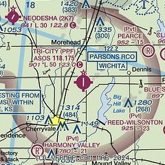
| Sectional chart |
|---|
|
| Airport distance calculator |
|---|
|
|
| Sunrise and sunset |
|---|
|
Times for 21-Apr-2025
| | Local
(UTC-5) | | Zulu
(UTC) |
|---|
| Morning civil twilight | | 06:13 | | 11:13 |
| Sunrise | | 06:40 | | 11:40 |
| Sunset | | 20:01 | | 01:01 |
| Evening civil twilight | | 20:29 | | 01:29 |
|
| Current date and time |
|---|
| Zulu (UTC) | 21-Apr-2025 22:53:34 |
|---|
| Local (UTC-5) | 21-Apr-2025 17:53:34 |
|---|
|
| METAR |
|---|
| KPPF | 212152Z AUTO 19008KT 10SM CLR 22/11 A3000 RMK AO2 SLP153 T02220111
|
KCFV
15nm S | 212152Z AUTO 18010KT 10SM CLR 23/08 A2999 RMK AO2 SLP154 T02280078
|
KIDP
17nm SW | 212235Z AUTO 17013KT 10SM CLR 22/11 A2999 RMK AO2
|
|
| TAF |
|---|
KCNU
20nm N | 211736Z 2118/2218 19009KT P6SM SKC FM221600 19014G21KT P6SM FEW250
|
|
| NOTAMs |
|---|
NOTAMs are issued by the DoD/FAA and will open in a separate window not controlled by AirNav.
|
|


